Palm Harbor in Pinellas County, Florida — The American South (South Atlantic)
Sacred Ground
Photographed by Quinton Spiaggi
1. Sacred Ground Marker
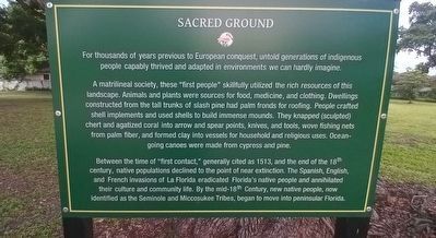
For thousands of years previous to European conquest, untold generations of indigenous people capably thrived and adapted in environments we can hardly imagine.
A matrilineal society, these "first people" skillfully utilized the rich resources of this landscape. Animals and plants were sources for food, medicine, and clothing. Dwellings constructed from the tall trunks of slash pine had palm fronds for roofing. People crafted shell implements and used shells to build immense mounds. They knapped (sculpted) chert and agatized coral into arrow and spear points, knives, and tools, wove fishing nets from palm fiber, and formed clay into vessels for household and religious uses. Ocean-going canoes were made from cypress and pine.
Between the time of "first contact," generally cited as 1513, and the end of the 18th century, native populations declined to the point of near extinction. The Spanish, English, and French invasions of La Florida eradicated Florida's native people and annihilated their culture and community life. By the mid-18th Century, new native people, now identified as the Seminole and Miccosukee Tribes,
this page online
Erected 2022 by Palm Harbor Historical Society.
Topics. This historical marker is listed in these topic lists: Anthropology & Archaeology • Colonial Era • Exploration • Indigenous Peoples and Communities. A significant historical year for this entry is 1513.
Location. 28° 2.955′ N, 82° 44.867′ W. Marker is in Palm Harbor, Florida, in Pinellas County. It can be reached from the intersection of Curlew Road (Florida Route 586) and Belcher Road, on the right when traveling west. Marker can be found near the wind phone at the Palm Harbor Museum. Touch for map. Marker is at or near this postal address: 2043 Curlew Road, Palm Harbor FL 34683, United States of America. Touch for directions.

Regionally, this marker is on Florida’s Gulf Coast and on Tampa Bay. It is also in the American South and on the Gulf Coast. Globally, it is in the North Atlantic Region, North America, a Gulf of Mexico state, the Western Hemisphere, the Western World, and the Anglosphere. Historically, it finds itself in what was once New Spain, the territory of the Mississippian Culture, one

Photographed by Quinton Spiaggi, 2022
2. Sacred Ground Marker
Other nearby markers. At least 8 other markers are within walking distance of this marker: Wind Phone (a few steps from this marker); Thos. W. Hartley's Cypress Ladder Factory (a few steps from this marker); Mr. Hartley's Mules/Dunedin Temple Mound (a few steps from this marker); Ethnobotany (a few steps from this marker); Grove House (within shouting distance of this marker); In Praise of Dogfennel (within shouting distance of this marker); The Whitehurst Well Relic of Pioneer Times (within shouting distance of this marker); Heritage Roses (within shouting distance of this marker). Touch for a list and map of all markers in Palm Harbor.
Also see . . . Palm Harbor Museum. (Submitted on July 26, 2024.)
Credits. This page was last revised on July 26, 2024. It was originally submitted on July 25, 2024, by Quinton Spiaggi of Palm Harbor, Florida. This page has been viewed 211 times since then and 33 times this year. Photos: 1, 2. submitted on July 25, 2024, by Quinton Spiaggi of Palm Harbor, Florida. • Bernard Fisher was the editor who published this page.
