Cartersville in Bartow County, Georgia — The American South (South Atlantic)
Remote Sensing at Etowah
| — | Etowah Indian Mounds State Historic Site | — |
Photographed by Brandon D Cross
1. Remote Sensing at Etowah Marker
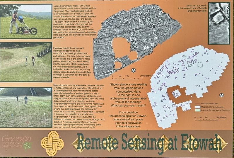
Electrical resistivity survey uses electrical resistance to map subsurface archaeological features and patterns. The area to be surveyed is first staked into a grid pattern. Metal probes (electrodes) are then inserted into the ground to obtain a reading of the local electrical resistance. As the technician walks the instrument along closely spaced parallel lines and takes readings, a computer logs the data at regular intervals.
Magnetometers and gradiometers measure the level of magnetization of any magnetic material like iron. Archaeologists use both instruments to detect magnetic anomalies of various types
this page online
(captions)
Shown above is one reading from the gradiometer's computerized data. To the right is one archaeological interpretation from all the readings. What can you see in each?
If you could be the archaeologist for Etowah, where would you place your next excavation in the village area?
What can you see in this enlarged view of fluxgate gradiomenter data?
Erected by Georgia Council on American Indian Concerns.
Topics. This historical marker is listed in these topic lists: Anthropology & Archaeology
Photographed by Brandon D Cross
2. Remote Sensing at Etowah Marker
Location. 34° 7.681′ N, 84° 48.437′ W. Marker is in Cartersville, Georgia, in Bartow County. It can be reached from Indian Mounds Road SE 0.2 miles south of Sequoyah Circle, on the left when traveling south. Located on the grounds of Etowah Indian Mounds State Historic Site. Touch for map. Marker is at or near this postal address: 813 Indian Mounds Road SE, Cartersville GA 30120, United States of America. Touch for directions.

Regionally, this marker is in the Mountains. It is also in the American South and specifically in the Deep South. Globally, it is in North America, the Western Hemisphere, the Western World, and the Anglosphere. Historically, it finds itself in what was once the original Cherokee Nation, the territory of the Mississippian Culture, one of the original Thirteen Colonies, one of the Confederate States of America, and the Antebellum South.
Other nearby markers. At least 8 other markers are within walking distance of this marker: Etowah Mounds (a few steps from this marker); Etowah’s Wattle and Daub House (a few steps from this marker); The Defensive Ditch/Borrow Pit (within shouting distance of this marker); A Return to Native Grasses (within shouting distance of this marker); A Chiefly Village on the Etowah (about 500 feet away, measured in a direct line); Etowah (Tumlin) Mounds (about 600 feet away); Mound A - Symbol of a Chiefdom (approx. 0.2 miles away); Etowah’s Past, Present, and Future (approx. 0.2 miles away). Touch for a list and map of all markers in Cartersville.
Also see . . .
1. City Beneath the Mounds. (Submitted on August 2, 2024, by Brandon D Cross of Flagler Beach, Florida.)
2. Etowah Indian Mounds State Historic Site. (Submitted on August 2, 2024, by Brandon D Cross of Flagler Beach, Florida.)
Credits. This page was last revised on August 3, 2024. It was originally submitted on August 2, 2024, by Brandon D Cross of Flagler Beach, Florida. This page has been viewed 200 times since then and 29 times this year. Photos: 1, 2. submitted on August 2, 2024, by Brandon D Cross of Flagler Beach, Florida. • Bernard Fisher was the editor who published this page.
