Manchester in Richmond, Virginia — The American South (Mid-Atlantic)
Transitions
| — | Richmond Slave Trail | — |
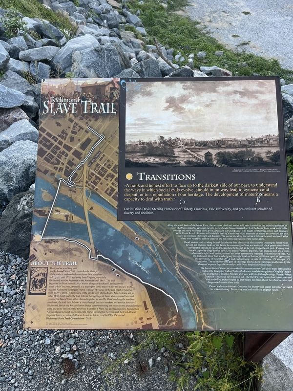
"A frank and honest effort to face up to the darkest side of our past, to understand the ways in which social evils evolve, should in no way lead to cynicism and despair, or to a repudiation of our heritage. The development of maturity means a capacity to deal with truth."
David Brion Davis, Sterling Professor of History Emeritus, Yale University, and pre-eminent scholar of slavery and abolition.
Along the south bank of the James River, the accounts cited and stories told have focused on the brutal experiences of enslaved Africans exported as human cargo to foreign lands. Accounts recited north of the James River speak to the noble courage and steely resilience of enslaved Africans in the United States who fought for their freedom in such episodes as the Creole Revolt. Features sill visible in the city's landscape recall memories of misery and coercion, but also serve as reminders of strength and devotion. The stories told along the trail as it follows the south and north sides of the river reveal the darkest shadows and the noblest aspirations of the human spirit.
Ahead, various markers along the trail describe
this page online
The Reconciliation Statue, an international commemoration of one of the many Transatlantic routes in the Triangular Trade of Enslaved Africans, stands in recognition of Virginia's role in the unimaginable plight of Africans who were sold into lifelong bondage. Nearby, Robert Lumpkin's infamous slave trading jail—the Devil's

Please, walk upon this trail. Continue this journey and accept the history revealed, for it is our history. May every step lead us all to a brighter future.
About the Trail
Designed as a walking path, the Richmond Slave Trail chronicles the history of the trade in enslaved Africans from their homeland to Virginia until 1778, and away from Virginia, especially Richmond, to other locations in the Americas until 1865. The trail begins at the Manchester Docks, which, alongside Rocketts Landing on the north side of the river, operated as a major port in the massive downriver slave trade, making Richmond the largest source of enslaved blacks on the east coast of America from 1830 to 1860. While many of the slaves were shipped on to New Orleans and to other Deep South ports, the trail follows the footsteps of those who remained here and crossed the James River, often chained together in a coffle. Once reaching the northern riverbank, the trail then follows a route through the slave markets and auction houses of Richmond, beside the Reconciliation Statue commemorating the international triangular slave trade and on to the site of the notorious Lumpkin’s Slave Jail and leading on to Richmond’s African Burial Ground, once called the Burial Ground for Negroes, and the First African Baptist Church, a center of African American life in pre-Civil War Richmond.
Erected 2011 by Richmond Slave Trail Commission.
Topics. This historical marker is listed in these topic lists: African Americans • Colonial Era • Industry & Commerce • Waterways & Vessels. A significant historical year for this entry is 1778.
Location. 37° 31.619′ N, 77° 26.116′ W. Marker is in Richmond, Virginia. It is in Manchester. It is on Hull Street (U.S. 360) north of Manchester Road, on the right. Touch for map. Marker is at or near this postal address: 1 Hull St, Richmond VA 23224, United States of America. Touch for directions.

Regionally, this marker is in Central Virginia. It is also in the American South and specifically in the Upper South. Globally, it is in North America, the Western Hemisphere, the Western World, and the Anglosphere. Historically, it finds itself in what was once the territory of the Mississippian Culture, one of the original Thirteen Colonies, one of the Confederate States of America, and the Antebellum South.
Other nearby markers. At least 8 other markers are within walking distance of this marker: Diversity Park (within shouting distance of this marker); Manchester Canal (within shouting distance of this marker); Mayo's Bridge (approx. 0.2 miles away); Richmond's Burgeoning Trade (approx. ¼ mile away); Manchester Lodge No. 14 (approx. ¼ mile away); John Mayo (approx. 0.3 miles away); Slavery Challenged (approx. 0.4 miles away); Pipeline Trail (approx. 0.4 miles away). Touch for a list and map of all markers in Richmond.
Another marker is no longer nearby. Transitions (has been replaced with this marker).
Related marker. Click here for another marker that is related to this marker. This marker has replaced the linked marker.
Credits. This page was last revised on September 8, 2024. It was originally submitted on September 8, 2024, by Devry Becker Jones of Washington, District of Columbia. This page has been viewed 198 times since then and 22 times this year. Photos: 1, 2. submitted on September 8, 2024, by Devry Becker Jones of Washington, District of Columbia.
