Bridgeport in Chicago in Cook County, Illinois — The American Midwest (Great Lakes)
Canal Origins Park

Photographed by Sean P. Flynn, September 25, 2024
1. Canal Origins Park Marker (panel 1)
[Panel 1:]
Welcome
Origins
Welcome to the place where water connections transformed Chicago from a tiny trading post into a national crossroads. The Illinois and Michigan Canal began here, and so does Chicago’s story.
Water highways
In the days before trains, cars and airplanes, water was the best way to move people and goods. The nation’s first “highways” were rivers and man-made canals. Canal boats traveling at five miles per hour were speedy compared to wagons and stagecoaches on rutted, muddy trails. Thanks to canals, people could transport the heavy goods — stone, lumber and coal — needed to fuel America’s westward expansion.
Geography is destiny
Illinois’ founders dreamed of connecting the East Coast (via the Erie Canal and Great Lakes) to the Gulf of Mexico (via the Mississippi River). Chicago was at the right spot. Cutting across a low continental divide known as the Chicago Portage, the I&M Canal united Lake Michigan with the Illinois River to provide the final link in a chain of waterways from New York to New Orleans.
[Panel 2:]
Beginnings: Prehistory – 1800
An ancient passageway
At the end
this page online
These fertile river valleys formed a passageway from the Great Lakes to the Mississippi River that people have traveled for thousands of years.
Native Americans
For more than 10,000 years, the Illinois, Potawatomi, Miami and other Native Americans lived, hunted and fished along the rivers of Illinois. Traveling by canoe, they used the waterways to establish vast trading networks extending as far as Florida.
The French
In 1673, Frenchmen Jolliet and Marquette were returning to Canada after exploring the Mississippi River. The Illinois Indians showed them a route to Lake Michigan via the Illinois, Des Plaines and Chicago Rivers. The river-to-lake shortcut made Jolliet dream of building a canal that would link the Great Lakes and Mississippi Watersheds.
[Caption beneath photo of mastodon:] At the end of the ice age about 14,000 years ago, mastodons and other now-extinct animals roamed Illinois.
[Caption of background photo:] 400 million

Photographed by Sean P. Flynn, September 25, 2024
2. Canal Origins Park Marker (panel 2)
[Caption beneath painting of of Native Americans:] Marquette and Jolliet met the Illinois Indians at their village along the Illinois River, near present day Starved Rock State Park.
[Caption next to painting of DuSable’s settlement:] In 1779, Jean DuSable established a fur trading post where the Chicago River met Lake Michigan.
[Panel 3:]
Canal Transformation: 1801 – 1848
An enduring vision [unreadable] Jolliet’s idea of a canal captured people’s imaginations for 150 years. It shaped Native American [unreadable], drew settlers and investors, and dictated the northern boundaries of the State of Illinois.
Canal town
A dismal swamp. That’s how Chicago, a town of 50 inhabitants, was described in 1830, the year the I&M Canal Commissioners mapped the city’s streets. Five years later, government treaties forced most Native Americans from Illinois, which was still the nation’s western frontier. In 1836, the monumental task of building the 96-mile I&M Canal began.
[Unreadable] is born
[Unreadable] 1848, after years of backbreaking labor, financial

Photographed by Sean P. Flynn, September 25, 2024
3. Canal Origins Park Marker (panel 3)
[Caption in bottom left:]
“Canal Land,” given to Illinois by the federal government, was sold to settlers and land speculators to help pay for canal construction.
[Caption next to photo of shovel:] [Unreadable] most of them [unreadable] dug the I&M Canal by hand.
[Caption for background photo:] By 1853, the canal transformed DuSable’s trading post into a thriving port city.
[Caption next to drawing of people shoveling:] Before the canal, farmers hauled grain by wagon to trade in Chicago.
[Caption next to drawing of boats on the canal:] Shipments of corn from Illinois to the east multiplied eight-fold the year after the canal opened.
[Panel 4:]
Canal Transformation: 1849 – 1899
A transportation revolution
In 1818, fur traders made the 100-mile trek from Chicago to LaSalle

Photographed by Sean P. Flynn, September 25, 2024
4. Canal Origins Park Marker (panel 4)
Trade flourished with the canal’s completion. It carried tons of stone, corn and coal from Illinois, lumber from Michigan, manufactured goods from the east, and sugar and fruit from the south.
The nation’s inland port
By 1853 the I&M Canal’s passenger trade was taken away by the railroads, but it remained competitive for shipping bulk cargo. In 1869, more freight vessels arrived at Chicago’s port than New York, New Orleans and San Francisco combined Business boomed and people from all over came to work in the lumberyards, stockyards and factories. The city’s population exploded to nearly 300,000 by 1870.
Reversing the river
A big city meant big problems. The Chicago River was an open sewer, which flowed into Lake Michigan, polluting the water supply. Typhoid, dysentery and other infectious diseases killed thousands. In 1871, a few months before the Great Chicago Fire, workers completed a huge project to deepen the I&M Canal and reverse the flow of the Chicago River, sending the city’s sewage

Photographed by Sean P. Flynn, September 25, 2024
5. Canal Origins Park Marker (panel 5)
[Caption beneath drawing of the canal:] This 1871 image of the I&M Canal “Bridgeport” Lock shows the city in the background.
[Caption next to painting of river reversal:] Huge crowds gathered here in 1871 to celebrate the reversal of the river.
[Caption for background photo:] Canal boats filled with lumber and stone met lake boats on the Chicago River in 1882.
[Caption for background photo on the right:] The pumping station wheel drew ater from the Chicago River at this site to supply the I&M Canal.
[Panel 4:]
Canal Legacy: 1900 – Today
A new era
The deepened I&M Canal provided only a short-term solution for protecting the city’s water supply. In 1900, the massive Sanitary & Ship Canal permanently reversed the flow of the Chicago River. The Sanitary & Ship was the first of a new generation of canals to follow the I&M Canal. Today, cargo is transported between Chicago’s busy harbors and the Mississippi River via the Illinois Waterway.
It all started with the I&M Canal
When waterways were our highways, the Illinois and Michigan Canal inspired explorers, settlers and Illinois’ founders to create a great

Photographed by Sean P. Flynn, September 25, 2024
6. Canal Origins Park Marker (panel 6)
[Caption next to photo on the left:] It took a workforce of 8,500 men to build the Sanitary & Ship Canal which paralleled the I&M between Chicago and Lockport.
[Caption for the background photo:] The Sanitary & Ship Canal was the world’s largest earth-moving project of the 19th century, and introduced technology later used to build the Panama Canal.
[Caption next to photo of the Stevenson Expressway:] The Stevenson (I-55), bulit over the first seven miles of the abandoned I&M Canal, was first known as the I&M Canal Expressway.
[Caption next to photo of the canal:] In Chicago, the I&M Canal became obsolete with the completion of the Sanitary & Ship Canal. It official closed for shipping when the Illinois Waterway opened in 1933.
[Panel 5:]
Canal Origins Park
A place of discovery
For many years this neighborhood, [unreadable], was known by neighborhood youth as “the Amazon.” Few knew that, as the site where the Illinois

Photographed by Sean P. Flynn, September 25, 2024
7. Canal Origins Park entrance
The historical markers are on the rear side of this short wall, which runs parallel to Ashland Avenue.
Partnerships make a park.
Since the late 1970s, the Canal Corridor Association has collaborated with community residents, educators, youth, public artists and the Chicago Park District, city, state and federal officials to reclaim and preserve this site. Today, Canal Origins Park is a place to learn about Chicago’s heritage as a canal town, enjoy a river edge oasis and reconnect with nature.
Gateway to a national treasure
Canal Origins Park is the eastern gateway to the I&M Canal National Heritage Corridor, a region rich with parks, trails, historic towns and scenic landscapes united by the I&M Canal. Visit www.canalcor.org or call 815.888.1100 to plan your visit.
Erected 2004 by Canal Corridor Association.
Topics and series. This historical marker is listed in these topic lists: Indigenous Peoples and Communities • Parks & Recreational Areas • Settlements & Settlers • Waterways & Vessels. In addition, it is included in the Illinois & Michigan Canal series list. A significant historical year for this entry is 1600.
Location. 41° 50.564′ N, 87° 39.937′ W.

Photographed by Sean P. Flynn, September 25, 2024
8. Canal Origins Park
This walkway features artwork panels; older articles about the park show that there used to be history-related panels here as well, but those are missing.

Regionally, this marker is on Chicago’s South Side. It is also in the American Midwest. Globally, it is in North America, on the Great Lakes, in the Western Hemisphere, in the Western World, and in the Anglosphere. Historically, it finds itself in what was once the Viceroyalty of New France, the territory of the Mississippian Culture, and the Northwest Territory.
Other nearby markers. At least 8 other markers are within walking distance of this location: Florian S. Jacolik Park (approx. ¼ mile away); James Marquette (approx. half a mile away); Julian Carrillo (approx. 0.7 miles away); Alvaro Obregon (approx. 0.7 miles away); Venustiano Carranza (approx. 0.7 miles away); Francisco I Madero

Photographed by Sean P. Flynn, September 25, 2024
9. Canal Origins Park
The Chicago River is in the rear, with some of the southern parts of the Chicago skyline in the far background.
Another marker is no longer nearby. Marquette and Jolliet Memorial (was approx. half a mile away but has been permanently removed).
More about this marker. The six panels are badly eroded by age and from the effects of graffiti and are very hard to read in certain spots. In particular the second and fifth of the six panels were significantly unreadable due to years of wear and tear. Older photos of a few of the panels were found online, allowing for more of the text to be transcribed here. The panels also include a Spanish inscription; it was not included here due to the difficulty in reading much of the text.
In addition to the five panels still posted at the entrance, the straight walkway from the entrance to Bubbly Creek (which forms the park's eastern edge) apparently used to have its own markers in addition to several pieces of art depicting the canal. While some of the artwork is still there as of September 2024, none of those historical markers were spotted.
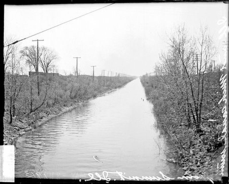
Chicago Daily News Collection, Chicago History Museum, May 1913
10. I&M Canal near Summit, Illinois (1913)
The caption from the Chicago History Museum says the photo was taken near Summit, Illinois, so likely about 8½ miles southwest of Canal Origins Park.
Regarding Canal Origins Park. Three-acre Canal Origins Park abuts the South Branch of the Chicago River to the north, and along its eastern edge a tributary of the Chicago River's South Branch known as Bubbly Creek. The creek got its name in the early 1900s from the gases that bubbled from the waste dumped by meatpacking businesses near the Union Stock Yards, which stood at the creek's source near Pershing Road (39th Street).
The Stock Yards closed in 1972, and the creek's fetid conditions are a distant memory. In 1999, the city acquired the land from the State of Illinois to create this park, and today it is a popular fishing spot with a splendid view of Chicago's downtown skyline. The Illinois & Michigan Canal corridor was declared a National Heritage Corridor in 1984, and this particular site was declared a Chicago Landmark by the city in 1996. (A square Chicago Landmark plaque was not spotted during a September 2024 visit, but there may be one in part of the park that was not visited.)
Also see . . . I&M Canal Heritage Area site. (Submitted on September 26, 2024, by Sean P. Flynn of Oak Park, Illinois.)
Credits. This page was last revised on February 24, 2025. It was originally submitted on September 26, 2024, by Sean P. Flynn of Oak Park, Illinois. This page has been viewed 302 times since then and 41 times this year. Photos: 1, 2, 3, 4, 5, 6, 7, 8, 9. submitted on September 26, 2024, by Sean P. Flynn of Oak Park, Illinois. 10. submitted on February 24, 2025, by Sean P. Flynn of Oak Park, Illinois.
