Summit in Cook County, Illinois — The American Midwest (Great Lakes)
Father Marquette Landed Here
1675

Photographed by Sean P. Flynn, October 16, 2024
1. Father Marquette Landed Here Marker
Erected 1895 by Chicago & Alton Railroad.
Topics. This historical marker is listed in these topic lists: Exploration • Railroads & Streetcars • Science & Medicine • Waterways & Vessels. A significant historical date for this entry is March 31, 1675.
Location. 41° 47.174′ N, 87° 48.669′ W. Marker is in Summit, Illinois, in Cook County. It is on South Archer Road (Illinois Route 171) 0.1 miles south of 57th Street, on the right when traveling south. The marker is on the eastern edge of Summit Park, close to the Summit Police Department building. Touch for map. Marker is at or near this postal address: 5700 South Archer Road, Summit Argo IL 60501, United States of America. Touch for directions.

Regionally, this marker is in Greater Chicago. It is also in the American Midwest. Globally, it is in North America, on the Great Lakes, in the Western Hemisphere, in the Western World, and
this page online
Other nearby markers. At least 8 other markers are within walking distance of this marker: Glaciers and Prairie (about 600 feet away, measured in a direct line); Veterans Memorial (about 600 feet away); The Freedom Run (about 600 feet away); 9/11 Memorial (approx. 0.3 miles away); a different marker also named The Freedom Run (approx. 0.4 miles away); 3” Anti-Tank Gun M5 (approx. half a mile away); Argo-Summit American Legion Post 735 (approx. 0.6 miles away); Mamie Till-Mobley (approx. 0.7 miles away). Touch for a list and map of all markers in Summit.
More about this marker. This marker is believed to be the first memorial in Illinois dedicated in honor of Father Jacques Marquette. It is a 19th century precursor and more modest companion to the much larger sculpture dedicated to Marquette and his travel companion Louis Jolliet about two miles northeast of here off Harlem Avenue at the Chicago Portage National Historic Site.
This memorial originally stood

Photographed by Sean P. Flynn, October 16, 2024
2. Father Marquette Landed Here Marker
The plaque on this set of boulders is believed to be the third, after the original two were stolen by vandals. The text of the current plaque was drafted by Robert Sommerville of the Chicago & Alton Railroad, likely in the 1920s. Sommerville's text is somewhat different because he had not been able to find a record of the original text, according to a history of Marquette memorials published by the Illinois Catholic Historical Society in the April 1931 edition of its Mid-America publication (link 2 below). According to Mid-America, the original plaque had this text: "On March 31, 1675, Father Marquette was flooded

Photographed by Sean P. Flynn, October 16, 2024
3. Father Marquette Landed Here Marker and Summit Park
Regarding Father Marquette Landed Here. Père Jacques Marquette, the Jesuit priest and explorer, made two visits to this area. The first, in 1673, came near the end of his famed voyage with fur trader Louis Jolliet, when they were the first white settlers to connect between the Great Lakes basin and Mississippi River. After reaching the Mississippi through Wisconsin after beginning their journey near modern-day De Pere, Wisconsin, Marquette and Joliet traveled all the way to the Arkansas River before turning around and heading back. They returned home via the Illinois River, taking it to the Des Plaines River at a spot not far from here. From here they portaged—carried their canoes across land—to the south branch of the Chicago River, about 10 miles east,
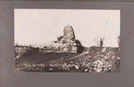
Courtesy of Chicago History Museum (ICHi-039314_017)
4. Marquette Memorial
The early photograph of this Marquette Memorial in Summit is part of a collection documenting the construction of the Chicago Drainage Canal. The manmade waterway, now called the Chicago Sanitary and Ship Canal, enabled the reversal of the Chicago River, which now flows toward the Mississippi River rather than draining into Lake Michigan.
Father Marquette returned about a year and a half later during another trip to establish a mission among a Native American tribe called the Kaskaskia. After being slowed by poor weather on his trip down from Green Bay, Marquette and his entourage wintered in 1674-75 in a makeshift cabin in Chicago, near where the modern Damen Avenue crosses the Chicago River, about 9 miles from here. (Another memorial to Marquette can be found at that site.)
The spring thaw flooded Marquette's encampment, and forced Marquette and his group to take refuge in the trees on the evening of March 30, 1675. The next day, March 31, Marquette and his entourage recommenced their journey, following the same portage route he and Jolliet had used in 1673. Here, near modern-day Summit, they found high ground at a spot called Point of Oaks. After taking several days waiting for better conditions, Marquette
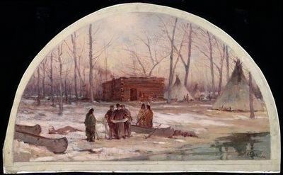
Courtesy of Chicago History Museum (ICHi-062501), 1900
5. "The Winter Quarters of Father Marquette, 1674"
A 1900 painting by Lawrence C. Earle depicts Marquette's 1674-75 winter camp, which was located roughly where the modern Damen Avenue meets the Chicago River. Once spring arrived, Marquette and his group would continue their journey and in March 1675 they stopped near where the modern village of Summit is located today.
Also see . . .
1. That Other Marquette Monument. From the Illinois Route 66 Association
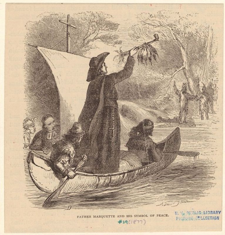
Excerpt: "Later in 1895, the C&A Railroad published a tourist booklet about notable sites along the newly dug Chicago Drainage Canal that riders on the Summit line could see from the train. One of the sites mentioned was the recently constructed Marquette memorial, a photo of which was featured on the booklet’s cover. Page 7 of the booklet notes that 'This monument consists of granite boulders of various kinds brought from the Lake Superior region by the glacial stream and deposited in this valley. The monument is, therefore, of great(Submitted on October 16, 2024, by Sean P. Flynn of Oak Park, Illinois.)geological as well as historical interest.' Another photo shows two large boulders; an accompanying explanation notes that 'the smaller boulder is of granite, weighing 7 or 8 tons, smoothed and scored by glacial action (also somewhat affected by water), and now forms the capstone of the Alton’s Marquette Monument at Summit' (Chicago & Alton Railroad, 1895)."Courtesy of the New York Public Library, Wallach Division Picture Collection, 18776. "Father Marquette and his symbol of peace"
2. Marquette Memorials. Page 291 of the April 1931 edition of the Mid-America journal, a publication by the Illinois Catholic Historical Society, offers an extensive history of Marquette memorials in the Midwest, including this memorial in Summit, Illinois. (Submitted on February 3, 2025, by Sean P. Flynn of Oak Park, Illinois.)
3. Encyclopedia of Chicago: Summit, IL. From the Chicago Historical Society
Excerpt: "Aptly named, Summit sits on the gentle rise separating the Chicago River from the Des Plaines. Various Indian tribes traveled for centuries through a mass of trails and portages that crossed the swampy interfluve. A hint of the original landscape can be found in the Chicago Portage National Historic Site, on Harlem Avenue in Lyons, just north of Summit.(Submitted on October 17, 2024, by Sean P. Flynn of Oak Park, Illinois.)
"Father Jacques Marquette and Louis Jolliet first used that portage during their return from the Mississippi in 1673. In the early 1830s Russell Heacock built an inn and farmed in the area. Summit is located along the Illinois & Michigan Canal, and in 1845 canal commissioners sold area land to defray construction costs."
4. Chicago & Alton Railroad. A history of the Chicago & Alton Railroad, from the Blackhawk Railway Historical Society
Excerpt: "Today, Canadian National owns the tracks between 21st Street in Chicago and Jackson Street in Joliet, and Union Pacific owns the tracks between Jackson Street and East St. Louis. Metra operates seven Heritage Corridor commuter trains each weekday between Chicago and Joliet and Amtrak operates ten intercity passenger trains every day between Chicago and St. Louis. Union Pacific owns and operates the CenterPoint Intermodal Facility on the south side of Joliet."(Submitted on October 17, 2024, by Sean P. Flynn of Oak Park, Illinois.)
Credits. This page was last revised on March 11, 2025. It was originally submitted on October 16, 2024, by Sean P. Flynn of Oak Park, Illinois. This page has been viewed 842 times since then and 146 times this year. Photos: 1, 2, 3. submitted on October 16, 2024, by Sean P. Flynn of Oak Park, Illinois. 4. submitted on October 21, 2024, by Sean P. Flynn of Oak Park, Illinois. 5, 6. submitted on October 17, 2024, by Sean P. Flynn of Oak Park, Illinois.
