
Leaf Mountain Township near Urbank in Otter Tail County, Minnesota — The American Midwest (Upper Plains)
Inspiration Peak
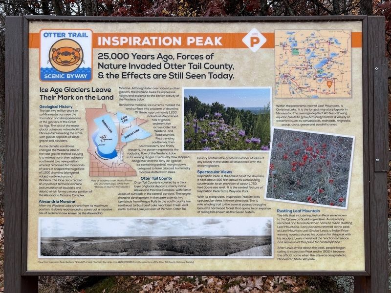
25,000 Years Ago, Forces of Nature Invaded Otter Tail County, & the Effects are Still Seen Today.
| — | Otter Trail Scenic Byway Site | — |
October 24, 2024
1. Inspiration Peak Marker
Ice Age Glaciers Leave Their Mark on the Land
Geological History
The last two million years or so Minnesota has seen the formation and disappearance of the glaciers of the Great Ice Age. The last of the major glacial advances retreated from Minnesota blanketing the state with glacial deposits of sand, gravel and boulders.
As the climatic conditions changed the Wadena lobe of the vast glacier melted, causing it to retreat north then advance southward to a new position where it remained for thousands of years. It shaped the huge field of 1,200 drumlins (elongated ridges) centered around Wadena. The lobe also created an important terminal moraine (accumulation of boulders and debris) which forms a major portion of the Alexandria Moraine Complex.
Alexandria Moraine
After the Wadena Lobe shrank from its maximum position, it slowly readvanced to construct a massive pile of sediment now known as the Alexandria Moraine. Although later overridden by other glaciers, the moraine owes its impressive height and expanse to the earlier activity of the Wadena Lobe.
Behind the moraine, ice currents molded the land surface
this page online
Otter Tail County
Otter Tail County is covered by a thick layer of glacial deposits, mainly in the Alexandria Moraine Complex, with flatter areas of outwash in the central portions. The largest moraine development in the state extends in a semicircle from Fergus Falls to the south county line, northeast to East Leaf Lake near Deer Creek, and north to Pine Lake just east of Perham. Otter Tail County contains the greatest number of lakes of any county in the state, all associated with the ancient glaciers.
Spectacular Views
Inspiration Peak, is the tallest hill of the drumlins. It rises about 400 feet above its surrounding countryside, to an elevation of about 1,750

October 24, 2024
2. Inspiration Peak Marker
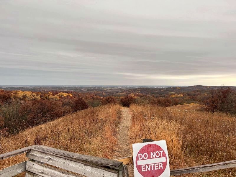
With its steep sides, Inspiration Peak affords spectacular views in three directions. The ¼ mile winding trail to the summit passes through a beautiful hardwood forest that opens to an expanse of rolling hills known as the Seven Sisters.
Within the panoramic view of Leaf Mountains, is Christina Lake. It is the largest migratory layover in Minnesota. The average depth of 4.5 feet allowing aquatic plants to grow providing food for a variety of waterfowl such as canvasbacks, redheads, ringnecks, scaup, coots, geese and sandhill cranes.
Rustling Leaf Mountain
The hills that include Inspiration Peak were known to the Ojibwe as Gaskibugwudjiwe. A missionary recorded and translated their name to mean Rustling Leaf Mountains. Early pioneers referred to the peak as Leaf Mountain until Sinclair Lewis, a Nobel Prize-winning novelist shared his passion for the peak with his readers. Lewis cherished the "enchanted peace and seclusion of this place for contemplation."
After Lewis wrote about the peak, people began calling it Inspiration Peak and in
October 24, 2024
3. View south from Inspiration Peak
Captions:
Map of Wadena Lobe, Hewitt Phase (30,000 years ago). [Map from "Billions of Years in Minnesota"]
View from Inspiration Peak, Sections 22 and 27 of Leaf Mountain Township, circa 1925 [#26989 from the collections of the Otter Tail County Historical Society]
Erected by Otter Tail Lakes Country Association.
Topics. This historical marker is listed in these topic lists: Arts, Letters, Music • Indigenous Peoples and Communities • Parks & Recreational Areas • Waterways & Vessels. A significant historical year for this entry is 1932.
Location. 46° 8.261′ N, 95° 34.67′ W. Marker is near Urbank, Minnesota, in Otter Tail County. It is in Leaf Mountain Township. It is on 120th Street 0.3 miles east of 435th Avenue. Located in Inspiration Peak State Wayside Park. Touch for map. Marker is at or near this postal address: 43749 120th St, Brandon MN 56315, United States of America. Touch for directions.

Regionally, this marker is in the American Midwest and in the Corn Belt. Globally, it is in North America, the Western Hemisphere, the Western World, and the Anglosphere. Historically, it finds itself in what was once Rupert’s Land, the territory of the Mississippian Culture, and the Louisiana Purchase.
Other nearby markers. At least 8 other markers are within 13 miles of this marker, measured as the crow flies: A different marker also named Inspiration Peak (a few steps from this marker); a different marker also named Inspiration Peak (approx. ¼ mile away); Vining (approx. 8.8 miles away); Clitherall (approx. 9.2 miles away); Old Clitherall (approx. 9.9 miles away); Brandon Auditorium (approx. 12 miles away); Leading a Community Transformation (approx. 12.3 miles away); Battle Lake (approx. 12.4 miles away).
Also see . . . Otter Trail Scenic Byway. Explore Minnesota website entry (Submitted on November 19, 2025, by Larry Gertner of New York, New York.)
Credits. This page was last revised on November 19, 2025. It was originally submitted on November 9, 2024. This page has been viewed 254 times since then and 45 times this year. Photos: 1, 2, 3. submitted on November 9, 2024.
