Port Perry in Durham Region, Ontario — Central Canada (North America)
Lake Scugog

Photographed by Cosmos Mariner, June 2, 2024
1. Lake Scugog Marker
Lake Scugog is often referred to as a 'man-made lake' due to the fact it was created in 1829 after a dam was built across the Scugog River at Lindsay, causing the water to rise in the Lake Scugog basin between six and eight feet.
The name "Scugog" comes from an Ojibwe word meaning "marshy waters". Prior to the flooding, the area was primarily wetland with a narrow river winding its way through thick wild rice and cranberries stands harvested by the native Mississaugas.
Lake Scugog is part of the Kawartha Lakes water system. It flows north to the Scugog River which feeds Sturgeon Lake and the rest of the Trent-Severn Waterway. From Lake Scugog you can go anywhere in the world by water.
The lake is 23.55 kilometres long, 5.8 kilometres at its widest, with a total shoreline of 172 kilometres. Its watershed covers 533.7 square kilometres, has a surface area of 63.5 square kilometres with an average depth of 1.4 metres and a maximum depth of 7.6 metres. Depth, area and volume are artificially maintained to this day through the Lindsay Dam.
Lake Scugog is a warm water lake home to an array of fish, including an abundance of largemouth
this page online
Erected by Township of Scugog.
Topics. This historical marker is listed in these topic lists: Agriculture • Animals • Indigenous Peoples and Communities • Waterways & Vessels. A significant historical year for this entry is 1829.
Location. 44° 6.32′ N, 78° 56.463′ W. Marker is in Port Perry, Ontario, in Durham Region. It can be reached from Water Street just north of Mary Street, on the right when traveling north. The marker is located along the walkway on the east side of Palmer Park, overlooking Lake Scugog. Touch for map. Marker is at or near this postal address: 175 Water Street, Port Perry ON L9L 1C4, Canada. Touch for directions.

Regionally, this marker is in Greater Toronto, specifically on the Golden Horseshoe, in the York, Durham and Headwaters Area, and in the Toronto Metropolitan Area. It is also in Central Canada. Globally, it is in North America, on the Great Lakes, in

2. Marker detail: Port Perry Wharf Dockhouse
Dockhouse at the end of the Port Perry wharf was used as a change room for swimmers during the early 1900s.
Other nearby markers. At least 8 other markers are within walking distance of this marker: Steamboats on Lake Scugog (within shouting distance of this marker); The Port Whitby and Port Perry Railway (within shouting distance of this marker); The Rotary Club of Port Perry (within shouting distance of this marker); Harvey Lillard (about 90 meters away, measured in a direct line); The Port Perry Grain Elevator (about 90 meters away); Daniel David Palmer (about 90 meters away); a different marker also named Daniel David Palmer (about 90 meters away); The Currie Grain Elevator (about 120 meters away). Touch for a list and map of all markers in Port Perry.
Also see . . .
1. The History of Lake Scugog.
Excerpt: In the 1830’s, permission was granted to build a mill at Lindsay. This required a “head” of water, so the Scugog River was dammed bringing the lake up ten feet. This first dam was destroyed(Submitted on November 21, 2024, by Cosmos Mariner of Cape Canaveral, Florida.)and the new dam, built further along the river, only brought the lake up four feet.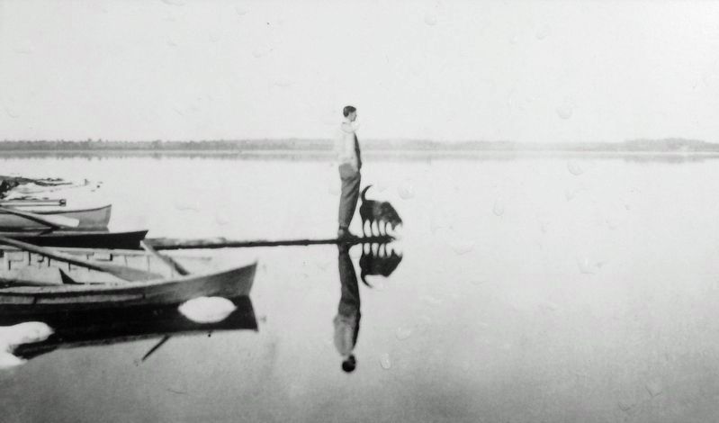 3. Marker detail: Tom ThomsonPhotograph of artist Tom Thomson (Group of Seven) overlooking Lake Scugog. Scugog was an inspiration for many of his paintings.
Many areas of forest, plowed fields, indigenous settlements, and even newly built settlers’ cabins, were inundated by the new water level. Then years of decomposition and swamp gas within the Scugog basin proved a great area for breeding disease-carrying mosquitoes. A native malaria made many ill with what they called “ague” at the time. The native malaria was less vigorous than tropical malaria and did not result in as many deaths, but it spread widely in newly populated, wet areas such as that found in the labour camps for the construction of the Rideau Canal and around the newly flooded Lake Scugog.
2. Lake Scugog History (Wikipedia).
Excerpt: Originally, it was essentially two lakes connected via a broad channel flowing through a marshy area along the north end. The lake was flooded approximately ten feet when William Purdy and his sons dammed the Scugog River at Lindsay (Upstream from the current dam and locks) in 1834 to power his grist mill. The stagnant(Submitted on November 21, 2024, by Cosmos Mariner of Cape Canaveral, Florida.)waters of the lake caused a wave of deadly fevers in the surrounding farms, and the new lake limits quickly became very unpopular with the local residents. On one day in the summer of 1838, settlers from the countryside surrounding the lake rose up and using axes, flintlocks and pitchforks, tore the dam apart, lowering the lake once more. Mr. Purdy was forced to lower the elevation to something approximating its natural maximum spring high-water level, a reduction in the height of the previous dam by about three feet. The Board of Works constructed the dam and a lock for navigation into Lake Scugog, which was completed in 1844 and included a log flume. 4. Marker detail: Catch of Fish, Lake Scugog, circa 1910

Photographed by Cosmos Mariner, June 2, 2024
5. Lake Scugog Marker
Looking east from Palmer Park across Lake Scugog.
Credits. This page was last revised on November 21, 2024. It was originally submitted on November 20, 2024, by Cosmos Mariner of Cape Canaveral, Florida. This page has been viewed 768 times since then and 229 times this year. Photos: 1, 2, 3. submitted on November 20, 2024, by Cosmos Mariner of Cape Canaveral, Florida. 4, 5. submitted on November 21, 2024, by Cosmos Mariner of Cape Canaveral, Florida.
