Hartfield in Middlesex County, Virginia — The American South (Mid-Atlantic)
Stingray Point
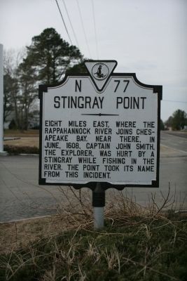
Photographed by Tom Fuchs, January 16, 2009
1. Stingray Point Marker
Erected 1947 by Virginia Conservation Commission. (Marker Number N-77.)
Topics and series. This historical marker is listed in these topic lists: Animals • Colonial Era • Exploration • Waterways & Vessels. In addition, it is included in the Virginia Department of Historic Resources (DHR) series list. A significant historical month for this entry is June 1608.
Location. 37° 33.064′ N, 76° 26.742′ W. Marker is in Hartfield, Virginia, in Middlesex County. It is at the intersection of General Fuller Highway (Virginia Route 33) and Twiggs Ferry Road ( Route 3), on the right when traveling east on General Fuller Highway. Touch for map. Marker is in this post office area: Hartfield VA 23071, United States of America. Touch for directions.

Regionally, this marker is on Virginia’s Middle Peninsula. It is also in the American South, specifically in the Upper South, in the Tidewater, in the Chesapeake Bay Region, and on the Eastern Seaboard. Globally, it is in the North Atlantic Region, North America, the Western Hemisphere, the Western World, and the Anglosphere. Historically, it finds itself in what was once the territory of the Mississippian Culture, one of the original Thirteen Colonies, one of the Confederate States of America, and the Antebellum South.
Other nearby markers. At least 8 other markers are within 6 miles of this marker, measured as the crow flies: Lower Methodist Church (approx. ¾ mile away); Naval Actions on Wilton Creek and the Rappahannock River (approx. 2.1 miles away); Dr. Copter — Flying Medicine to Tangier (approx. 3½ miles away); Gloucester County / Mathews County
this page online
Another marker is no longer nearby. Lower Methodist Church (was approx. ¾ mile away but has been replaced with another marker now near it).
Credits. This page was last revised on December 25, 2019. It was originally submitted on January 17, 2010, by Tom Fuchs of Greenbelt, Maryland. This page has been viewed 1,081 times since then and 30 times this year. Photo 1. submitted on January 17, 2010, by Tom Fuchs of Greenbelt, Maryland.
Editor’s want-list for this marker. A picture of Stingray Point. • Can you help?
