Counce in Hardin County, Tennessee — The American South (East South Central)
Mississippian Indians
Shiloh Indian Mounds National Historic Park
| — | National Park Service, U.S. Department of the Interior | — |
Photographed by Sandra Hughes, September 1, 2009
1. Mississippian Indians Marker
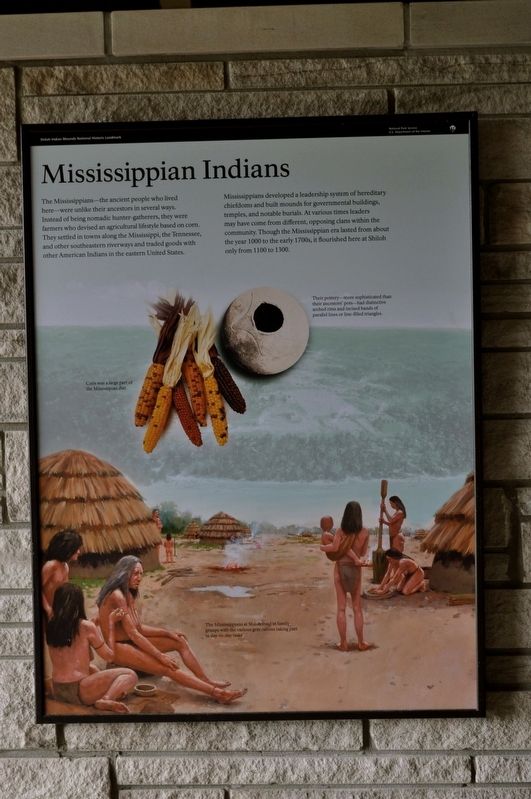
The Mississippian-the ancient people who lived here-were unlike their ancestors in several ways. Instead of being nomadic hunter-gatherers, they were farmers who devised an agricultural lifestyle based on corn. They settled in towns along the Mississippi, the Tennessee, and other southeastern river-ways and traded goods with other American Indians in the eastern United States.
Mississippians developed a leadership system of hereditary chiefdoms and built mounds for governmental buildings, temples, and notable burials. At various times leaders may have come from different, opposing clans within the community. Though the Mississippian era lasted from about the year 1000 to the early 1700s, it flourished here at Shiloh only from 1100 to 1300.
Their pottery - more sophisticated than their ancestors' pots - had distinctive arched rims and incised bands of parallel lines or line-filled triangles.
Erected by National Park Service, U.S. Department of the Interior.
Topics. This historical marker is listed in these topic lists: Anthropology & Archaeology • Indigenous Peoples and Communities • Man-Made Features. A significant historical year for this entry is 1000 CE.
Location. 35° 8.482′ N, 88° 19.61′ W. Marker is in Counce, Tennessee, in Hardin County. It is on Riverside Drive east of Hamburg Savannah Road, on the left when traveling east. Marker is located at the Orientation Shelter Shiloh Indian Mounds National Historic Landmark Interpretive Trail. Touch for map. Marker is at or near this postal address: 275 Browns Landing Rd, Shiloh TN 38376, United States of America. Touch for directions.

Regionally, this marker is in West Tennessee. It is also in the American South and specifically in the Upper South. Globally, it is in North America, the Western Hemisphere, the Western World, and the
this page online
Other nearby markers. At least 8 other markers are within walking distance of this marker: Chickasaw Homeland (here, next to this marker); Sifting the Evidence (a few steps from this marker); Camp of 17th Kentucky Infantry (within shouting distance of this marker); Shiloh Indian Mounds (within shouting distance of this marker); A Temporary Wall (within shouting distance of this marker); Kentucky Regiments at Battle of Shiloh (within shouting distance of this marker); Crossing the Palisade (about 300 feet away, measured in a direct line); Signs of Dwellings (about 500 feet away).
Credits. This page was last revised on August 13, 2025. It was originally submitted on August 14, 2017, by Sandra Hughes Tidwell of Killen, Alabama, USA. This page has been viewed 429 times since then and 42 times this year. Last updated on April 15, 2025, by David Austin of Scotts Hill, Tennessee. Photo 1. submitted on August 14, 2017, by Sandra Hughes Tidwell of Killen, Alabama, USA. • Devry Becker Jones was the editor who published this page.
