Marshfield in Webster County, Missouri — The American Midwest (Upper Plains)
Trail of Tears
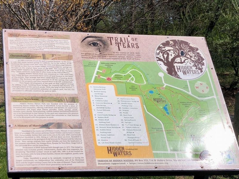
Photographed by Duane and Tracy Marsteller, April 7, 2025
1. Trail of Tears Marker
About Hidden Waters Nature Park
Hidden Waters Nature Park, located on Historic Route 66 in Marshfield, Missouri, is home to the Callaway Cabin circa 1853. The cabin offers a glimpse of Ozarks family life in the 1800's where Parham and Nancy Callaway raised their 13 children in the 16 by 18 foot building.
The park is located in the heart of Marshfield. It features beautiful waking trails, ponds, waterfalls, bridges, gardens and fourteen springs that form the headwaters of the Niangua River.
Chronological History
In 1880 a tornado struck the park's current location. As the story is told. that storm caused springs to suddenly rise to the surface. In all likelihood the strong winds blew away the vines and debris that covered the springs so they were no longer hidden. Fourteen separate springs are included on the original three acres of the park. This constant flow of spring water supplies the headwaters of
this page online
Hidden Waters Nature Park was conceived in 1998 when Dan and Zoann Beckner purchased three acres of land located in the heart of Marshfield. That acreage had been subdivided for a housing development. The Beckners saw great potential in all the springs that were located on the property and they wanted them to be left undisturbed.
They began development of the park on that original acreage by adding a trail, building three bridges for crossing the streams and enlarging three of the natural ponds. With the help of Jack Watters, a city alderman who realized the potential of a nature park, the city was persuaded to officially establish the park in 2003.
Mission Statement
Hidden Waters Nature Park was founded with the purpose of preserving Nature within the City of Marshfield. It has become a place of relaxation and tranquility, offering individuals and families an opportunity to experience and enjoy what Nature provides. Trails, springs, ponds, streams, trees, shrubs, floral planting, wildlife habitat and historical features are to be maintained so that visitors to the park may experience the pleasure of stepping away from the everyday hustle that surrounds us. Park features are to be developed with this purpose in mind.
A History of Marshfield
Mashfield is the county seat of Webster County, Missouri. It was named in honor of prominent 19th century politician Daniel Webster and his home in Marshfield, Massachusetts. Settlers first came to the area in the early 1850s and formally established Marshfield in 1856. Sitting at 1,490 feet above sea level, Marshfield is uniquely positioned on the geological divide between the Missouri and the Arkansas Rivers. Many springs originate from nearby hillsides and form the headwaters of four separate watersheds: the Niangua River, Pomme De Terre River, Osage Fork of the Gasconade River and the James River.
Predecessors of BNSF Railroad built through town in 1872. This helped to stimulate early economic growth. Unfortunately, shortly after that expansion, the devastating "Marshfield Cyclone" struck on April 18th, 1880. It all but leveled the town. Survivors, with the help of their families, friends and neighbors, quickly came together to rebuild.
Today, Marshfield is proud to be nationally recognized as having the longest continuously run Independence Day celebration west of the Mississippi River and the longest running County Fair in the state of Missouri. These traditions continue to build legacies of which future generations can be proud.
Erected by Friends of Hidden Waters.
Topics and series. This historical marker is listed in these topic lists: Disasters • Indigenous Peoples and Communities • Parks & Recreational Areas • Waterways & Vessels. In addition, it is included in the Trail of Tears series list. A significant historical date for this entry is April 18, 1880.
Location. 37° 20.482′ N, 92° 54.917′ W. Marker is in Marshfield, Missouri, in Webster County. It can be reached from West Hubble Drive 0.1 miles north of Boulson Terrace, on the right when traveling north. Touch for map. Marker is at or near this postal address: 716 W Hubble Dr, Marshfield MO 65706, United States of America. Touch for directions.

Regionally, this marker is in Southwest Missouri and in Greater Springfield. It is also in the American Ozarks, in the Lewis & Clark Corridor, and in the Corn Belt. Globally, it is in North America, the Western Hemisphere, the Western World, and the Anglosphere. Historically, it finds itself in what was once the territory of the Mississippian Culture, the Louisiana Purchase, and the Antebellum South.
Other nearby markers. At least 8 other markers are within walking distance of this marker: In Remembrance of Those Who Helped Shape Our Community (approx. half a mile away); Howitzer, Medium, Towed (approx. half a mile away); Edwin Hubble (approx. half a mile away); Webster County War Memorial (approx. half a mile away); Edwin Powell Hubble (approx. half a mile away); Marshfield Hand Dug Well (approx. half a mile away); Webster County (approx. half a mile away); Veterans Memorial (approx. half a mile away). Touch for a list and map of all markers in Marshfield.
Credits. This page was last revised on October 24, 2025. It was originally submitted on April 28, 2025, by Duane and Tracy Marsteller of Murfreesboro, Tennessee. This page has been viewed 204 times since then and 44 times this year. Photo 1. submitted on April 28, 2025, by Duane and Tracy Marsteller of Murfreesboro, Tennessee.
Editor’s want-list for this marker. Wide-view photo of maker and surrounding area in context. • Can you help?
