Hayesville in Clay County, North Carolina — The American South (South Atlantic)
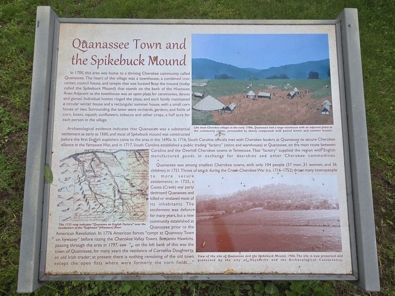
Quanassee Town and the Spikebuck Mound
Photographed by Mark Parker, May 10, 2025
1. Quanassee Town and the Spikebuck Mound Marker
In 1700, this area was home to a thriving Cherokee community called Quanassee. The heart of the village was a townhouse, a combined civic center, council house, and temple that was located atop the mound (today called the Spikebuck Mound) that stands on the bank of the Hiwassee River. Adjacent to the townhouse was an open plaza for ceremonies, dances and games. Individual homes ringed the plaza, and each family maintained a circular winter house and a rectangular summer house, with a small corn house or two. Surrounding the town were orchards, gardens, and fields of corn, beans, squash, sunflowers, tobacco and other crops, a half acre for each person in the village.
Archaeological evidence indicates that Quanassee was a substantial settlement as early as 1500, and most of Spikebuck mound was constructed before the first English explorers came to the area in the 1690s. In 1716, South Carolina officials met with Cherokee leaders at Quanassee to secure Cherokee alliance in the Yamassee War, and in 1717, South Carolina established a public trading "factory" (store and warehouse) at Quanassee, on the main route between
this page online
Quanassee was among smallest Cherokee towns, with only 104 people (37 men, 31 women, and 36 children) in 1721. Threat of attack during the Creek-Cherokee War (ca. 1716-1752) drove many townspeople into more secure settlements; in 1725, a Coosa (Creek) war party destroyed Quanassee, and killed or enslaved most of its inhabitants. The settlement was defunct for many years, but a new community established at Quanassee prior to the American Revolution. In 1776 American forces "campt at Quannasy Town on hywasey" before razing the Cherokee Valley Towns. Benjamin Hawkins, passing through the area in 1797, saw "on the left bank of this was the town of Quannasee, for many years the residence of Cornelius Daughterty, an old Irish trader; at present there is nothing remaining of the old town except the open flats where were formerly the corn fields...."
(Captions)
This 1725 map indicates "Quenesee an English Factory" near the headwaters of the "Euphasee" (Hiwasses) River.
Like most Cherokee villages in the early 1700s, Quenassee had a large townhouse with an adjacent plaza as the community center, surrounded by family compounds with paired winter and summerhouses.
View of the site of Quanassee and the Spikebuck Mound, 1966. The site is now preserved and protected by the city of Hayesville and the Archaeological Conservancy.
Topics.

Photographed by Mark Parker, May 10, 2025
2. Wide view of Quanassee Town and the Spikebuck Mound and other markers
Location. 35° 2.859′ N, 83° 48.516′ W. Marker is in Hayesville, North Carolina, in Clay County. It is on Ball Park Drive 0.4 miles east of Anderson Street when traveling east. From the parking lot, take the paved path 1/10 mile past the bridge. The marker is at the end of the path. Touch for map. Marker is at or near this postal address: 384 Ball Pk Dr, Hayesville NC 28904, United States of America. Touch for directions.

Regionally, this marker is in North Carolina’s Mountains. It is also in the American South, specifically in the Upper South, in Appalachia, and specifically in Southern Appalachia. Globally, it is in North America, the Western Hemisphere, the Western World, and the Anglosphere. Historically, it finds itself in what was once the original Cherokee Nation, the territory of the Mississippian Culture, one of the original Thirteen Colonies, one of the Confederate States of America, and

Photographed by Mark Parker, May 10, 2025
3. To reach the marker, find the path near field #6
Other nearby markers. At least 8 other markers are within walking distance of this marker: Cherokee Towns Circa 1700-1740 (here, next to this marker); The Spikebuck Mound and the Origins of Quanassee (here, next to this marker); A Tribute to Traditional Music (approx. half a mile away); A Tribute To Our Quilting Heritage (approx. half a mile away); Historic Clay County Courthouse (approx. half a mile away); Fort Hembree (approx. 0.6 miles away); In Memory Our War Dead (approx. 0.6 miles away); George W. Truett (approx. 0.6 miles away). Touch for a list and map of all markers in Hayesville.
Another marker is no longer nearby. Quanassee Town and the Spikebuck Mound (has been replaced with this marker).
Related marker. Click here for another marker that is related to this marker.

Photographed by Mark Parker, May 10, 2025
4. Continue along the path and cross the bridge. Markers are just past the bridge

Photographed by Mark Parker, May 10, 2025
5. Closeup of the 1725 map on the Quanassee Town and the Spikebuck Mound Marker
Credits. This page was last revised on May 13, 2025. It was originally submitted on May 12, 2025, by Mark Parker of Hickory, North Carolina. This page has been viewed 246 times since then and 48 times this year. Photos: 1, 2, 3, 4, 5. submitted on May 12, 2025, by Mark Parker of Hickory, North Carolina. • Devry Becker Jones was the editor who published this page.
