
Steedman in Callaway County, Missouri — The American Midwest (Upper Plains)
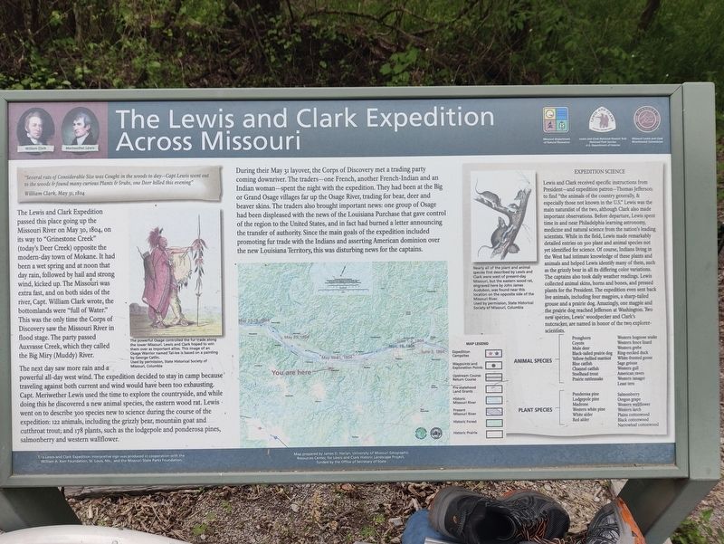
The Lewis and Clark Expedition Across Missouri
Photographed by John Ridley, April 28, 2023
1. The Lewis and Clark Expedition Across Missouri Marker
"Several rats of Considerable Size was Cought in the woods to day—Capt Lewis went out to the woods & found many curious Plants & Srubs, one Deer killed this evening"
William Clark, May 31, 1804
The Lewis and Clark Expedition passed this place going up the Missouri River on May 30, 1804, on its way to "Grinestone Creek" (today's Deer Creek) opposite the modern-day town of Mokane. It had been a wet spring and at noon that day rain, follwed by hail and strong wind, kicked up. The Missouri was extra fast, and on both sides of the river, Capt. William Clark wrote, the bottomlands were "full of Water." This was the only time the Corps of Discovery saw the Missouri River in flood stage. The party passed Auxvasse Creek, which they called the Big Miry (Muddy) River.
The next day saw more rain and a powerful all-day west wind. The expedition decided to stay in camp because traveling against both current and wind would have been too exhausting. Capt. Meriwether Lewis used the time to explore the countryside, and while doing this he discovered a new animal species, the eastern wood rat. Lewis went on to describe 300 species
this page online
During their May 31 layover, the Corps of Discovery met a trading party coming downriver. The traders–one French, another French-Indian and an Indian woman–spent the night with the expedition. They had been at the Big or Grand Osage villages far up the Osage River, trading for bear, deer and beaver skins. The traders also brought important news: one group of Osage had been displeased with the news of the Louisiana Purchase that gave control of the region to the United States, and in fact had burned a letter announcing the transfer of authority. Since the main goals of the expedition included promoting fur trade with the Indians and asserting American dominion over the new Louisiana Territory, this was disturbing new for the captains.
Expedition Science
Lewis and Clark received specific instructions from President–and expedition patron–Thomas Jefferson: to find "the animals of the country generally, & especially those not known in the the U.S." Lewis was the main naturalist of the two, although Clark also made important observations. Before departure, Lewis spent time in and near Philadelphia learning astronomy, medicine and natural science from the nation's leading scientists. While in the field, Lewis made remarkably detailed entries on 300 plant and animal species not yet identified for science. Of course, Indians living in the West had intimate knowledge of these plants and animals and helped Lewis identify many of them, such as the grizzly bear in all its differing color variations. The captains also took daily weather readings. Lewis collected animal skins, horns and bones, and pressed plants for the President. The expedition even sent back live animals, including four magpies, a sharp-tailed grouse and a prairie dog. Amazingly, one magpie and the prairie dog reached Jefferson at Washington. Two new species, Lewis' woodpecker and Clark's Nutcracker, ar named in honor of the two explorer-scientists.
Erected by Missouri Department of Natural Resources; National Park Service, U.S. Department of the Interior; Missouri Lewis and Clark Bicentennial Commission.
Topics. This historical marker is listed in these topic lists: Environment • Exploration • Indigenous Peoples and Communities • Science & Medicine. A significant historical date for this entry is May 30, 1804.
Location. 38° 42.484′ N, 91° 47.934′ W. Marker is in Steedman, Missouri, in Callaway County. It can be reached from Katy Trail west of County Road 457, on the right when traveling west. Touch for map. Marker is in this post office area: Steedman MO 65077, United States of America. Touch for directions.

Regionally, this marker is in Little Dixie and in the Missouri River Corridor. It is also in the American Midwest, in the Lewis & Clark Corridor, and in the Corn Belt. Globally, it is in North America, the Western Hemisphere, the Western World, and the Anglosphere. Historically, it finds itself in what was once the territory of the Mississippian Culture, the Louisiana Purchase, and the Antebellum South.
Other nearby markers. At least 8 other markers are within 5 miles of this marker, measured as the crow flies: Old Jail - 1930 (approx. 2.7 miles away); Portland to Mokane (approx. 4.4 miles away); Portland to McKittrick (approx. 4.4 miles away); Mysteries of Standing Rock (approx. 4½ miles away); History of Mokane (approx. 4½ miles away); Mokane to Portland (approx. 4½ miles away); Mokane to Tebbetts (approx. 4½ miles away); Katy Railroad (approx. 4½ miles away).
Credits. This page was last revised on May 18, 2025. It was originally submitted on May 16, 2025, by John Ridley of Chelsea, Michigan. This page has been viewed 158 times since then and 26 times this year. Photo 1. submitted on May 16, 2025, by John Ridley of Chelsea, Michigan. • Devry Becker Jones was the editor who published this page.
