
Queenston in Niagara-on-the-Lake in Niagara Region, Ontario — Central Canada (North America)
Landscape Of Nations - Six Nations & Native Allies Commemorative Memorial
Paysage Des Nations - Le Commémoratif Mémorial Des Six Nations Et Les Alliés Autochtones

Photographed by Kevin Westell, July 3, 2025
1. Landscape Of Nations - Marker (English)
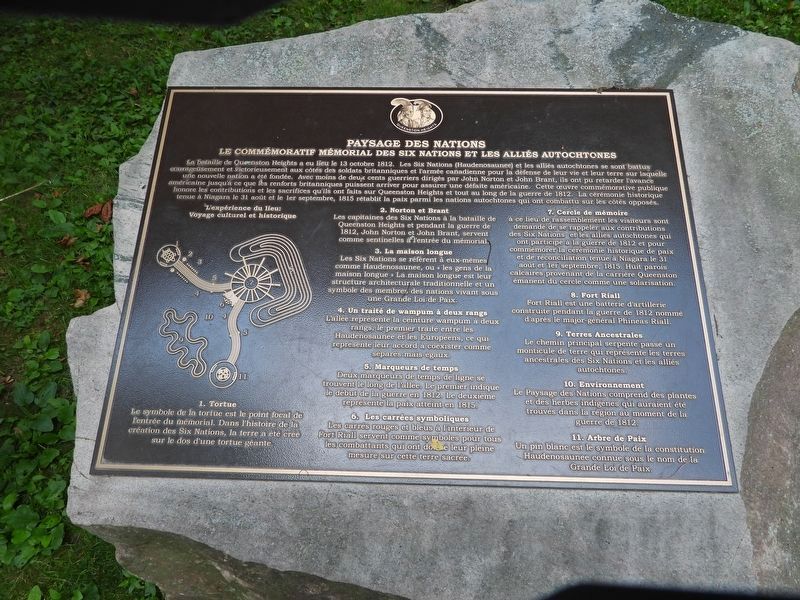
A handy map of the memorial is on the left side of the marker.
 [ Plaque 1 of 3 ]
On October 13, 1812, at the Battle of Queenston Heights, Six Nations (Haudenosaunee) and Native Allies fought bravely and victoriously alongside British forces and Canadian militia in defence of life and land upon which a new nation was founded. With less than two hundred warriors led by John North and John Brant, they beat back the American advance until British reinforcements could arrive to ensure American surrender. This commemorative public artwork honours the contributions and sacrifices they made on Queenston Heights and throughout the War of 1812 - and - recognizes the historic ceremony of peace and reconciliation held in Niagara on August 31 and September 1, 1815 that restored peace between the Native nations who fought on opposite sides.
The Experience of Place: Cultural and Historical Journey
[ There is a map of the memorial, with eleven numbered spots. ]
1. Turtle: The turtle symbol is the focal point of entry to the memorial. In the Six Nations creation story the earth was created on the back of a giant turtle.
2. Norton and Brant: Six Nations
this page online
3. Longhouse: The Six Nations refer to themselves as Haudenosaunee, or "People of the Longhouse." The longhouse is their traditional architectural structure and a symbol of the member nations living under one Great Law of Peace.
4. Two Row Wampum Path: The walkway represents the Two Row Wampum Belt, the first treaty between the Haudenosaunee and Europeans, representing their agreement to coexist as separate but equal.
5. Time Markers: Two time-line markers are found along the walkway. The first indicates the start of the war in 1812. The second marks when peace was achieved in 1815.
6. Symbolic Squares: The red and blue squares inside Fort Riall serve as symbols for all combatants who fought and gave their last full measure upon this hallowed ground.
7. Memory Circle: At this gathering place visitors are asked to remember the contributions of Six Nations and Native Allies who participated in the War of 1812 and to commemorate the historic ceremony
Photographed by Kevin Westell, July 3, 2025
2. Landscape Of Nations - Marker (French)
8. Fort Riall: Fort Riall is an artillery battery built during the War of 1812 named after Major General Phineas Riall.
9. Ancestral Lands: The main path meanders past an earthen berm that represent ancestral lands of Six Nations and Native Allies.
10. Environment: Landscape of Nations features indigenous plants of grasses that would have been found in the region at the time of the War of 1812.
11. Tree of Peace: An eastern white pine stands as a symbol of the Haudenosaunee constitution known as the Great Law of Peace.
[ Plaque 2 of 3 ]
La bataille de Queenston Heights a eu lieu le 13 octobre 1812. Les Six Nations (Haudenosaunee) et les alliés autochtones se sont battus courageusement et victorieusement aux côtés des soldats britanniques et l'armée canadianne pour la défense de leur vie et leur terre sur laquelle une nouvelle nation a été fondée. Avec moins de deux cents guerriers dirigés par John Norton et John Brant,
Photographed by Kevin Westell, July 3, 2025
3. Landscape Of Nations - Marker (donors)
L'expérience du lieu: Voyage culturel et historique
[ Il y a un plan du mémorial, avec onze points numérotés. ]
1. Tortue: Le symbole de la tortue est le point focal de l'entrée du mémorial. Dans l'histoire de la création des Six Nations, le terre a été créé sur le dos d'une tortue géante.
2. Norton et Brant: Les capitaines des Six Nations à la bataille de Queenston Heights et pendant la guerre de 1812, John Norton et John Brant, servent comme sentinelles à l'entrée du mémorial.
3. La Maison longue: Les Six Nations se réfèrent à eux-mêmes comme Haudenosaunee, ou "les gens de la maison longue" La maison longue est leur structure architecturale traditionnelle

Photographed by Kevin Westell, July 3, 2025
4. Landscape Of Nations - Marker in context
The photo faces south-east. The marker - 3 plaques on 3 stones - is near the two statues of Indigenous warriors, and near "the longhouse" - the hoops over the walkway leading into the memorial.
4. Un traité de wampum à deux rangs: L'allée représente la ceinture wampum à deux rangs, le premier traité entre les Haudenosaunee et les Européens, ce qui représente leur accord à coexister comme séparés mais égaux.
5. Marqueures de temps: Deux marqueurs de temps de ligne se trouvent le long de l'allée. Le premier indique le début de la guerre en 1812. Le deuxième représent la paix atteint en 1815.
6. Les carrées symboliques: Les carrés rouges et bleus à l'intérieur de Fort Riall servent comme symboles pour tous les combattants qui ont donné leur pleine mesure sur cette terre sacrée.
7. Cercle de mémoire: à ce lieu de rassemblement les visiteurs sont demandé de se rappeler aux contributions des Six Nations et les alliés autochtones qui ont participé à la guerre de 1812 et pour commémorer la cérémonie historique de paix et de réconciliation tenue à Niagara le 31 août et 1er septembre, 1815. Huit parois calcaires provenant de la carrière Queenston émanent du cercle comme une solarisation.
8. Fort Riall: Fort
Photographed by Kevin Westell, July 3, 2025
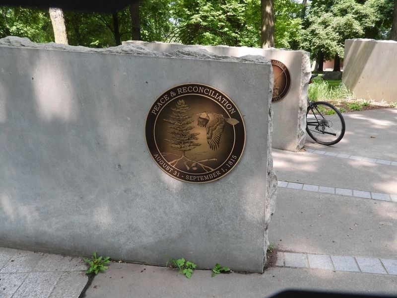
5. A stone slab and Image on the Circle Of Memories (Point 7 on the memorial)
9. Terres Ancestrales: Le chemin principal serpente passé un monticule de terre qui représente les terres ancestrales des Six Nations et les alliés autochtones.
10. Environnement: Le Paysage des Nations comprend des plantes et des herbes indigènes qui auraient été trouvés dans la région au moment de la guerre de 1812.
11. Arbre de Paix: Un pin blanc est le symbole de la constitution Haudenosaunee connue sous le nom de la Grande Loi de Paix.
[ Plaque 3 of 3 ]
Landscape Of Nations
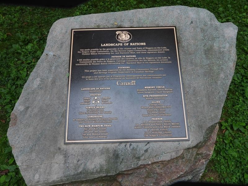
was made possible by the generosity and the citizens and Town of Niagara-on-the-Lake, the Niagara Parks Commission, the Six Nations Legacy Consortium, commissioned artists
Fleisher Ridout Partnership Inc. and Raymond Skye, and these signature donors:
Paysage Des Nations
a été rendue possible grâce à la générosité des citoyens, la ville de Niagara-on-the-Lake, la Commission des Parcs du Niagara, l'héritage Consortium des Six Nations, les artistes commandés de Fleisher Ridout Partnership
Photographed by Kevin Westell, July 3, 2025
6. Collage of the Images on the Circle Of Memories (Point 7 on the memorial)
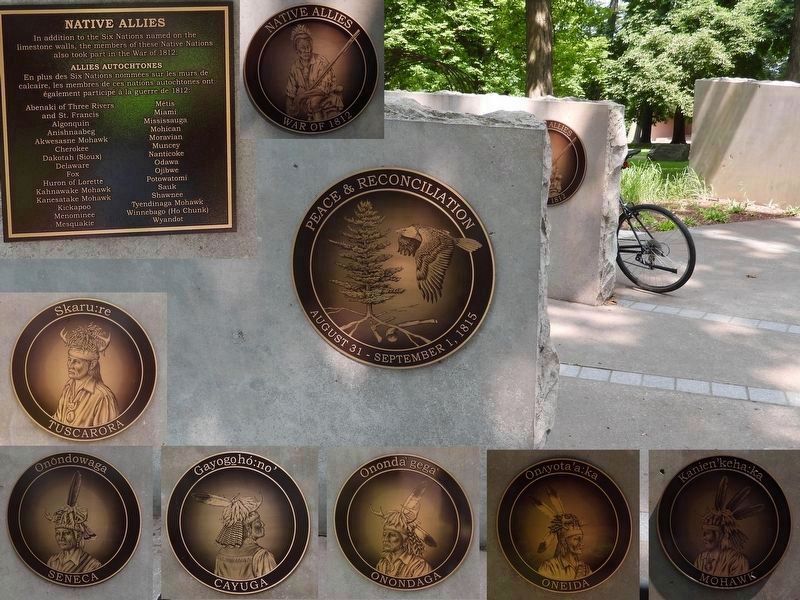
On the rock slabs in The Circle Of Memories, there are pictures depicting the 6 member nations of the Iroquois League, and also a list of the other Native Allies in the War of 1812.
Founding
This project has been supported by the Building Communities Through Arts and Heritage Program, Department of Canadian Heritage.
Ce projet a été appuyé par le Programme Développement des communautés par le biais des arts et du patrimoine du ministère de Patrimoine canadien.
Canada
Landscape of Nations
Anonymous
Statues
Ontario Trillium Foundation /
Fondation Trillium de l'Ontario
Turtle Island
J. Richard and Diane Armstrong and Family
Longhouse
In memory of Suzanne Rochon Burnett and Gordon Winston Burnett
Two Row Wampum Trail
Hal and Kim Gould
Jay and Jan Gould
Tim and Bonnie Gould
John and Liz Hawley
Memory Circle
Elizabeth Surtees, David Murray, Adam Sargeant, Claire Sargeant
Site Preservation
Walker Industries
Allies
Vintage Inns
Bruce and Vladka Mitchell
Fallsview Casino
TD Bank Group
Ontario Power Generation
Friends
A.L. Branscombe Family
Drs. Richard and Nancy Smith Merritt
Robert Timothy and Lisa Marie Johnson
E. Werner Family
Court Holdings Limited
The Niagara Foundation
Erected 2016.
Topics. This historical marker and memorial is listed in these topic lists: Colonial Era • Indigenous Peoples and Communities • Peace • War of 1812. A significant historical year for this entry is 1812.
Location. 43° 9.577′ N, 79° 3.212′ W. Marker is in Niagara-on-the-Lake, Ontario, in Niagara Region. It is in Queenston. It can be reached from Niagara River Parkway. This marker and the memorial is within Queenston Heights Park, 100 metres south of Brock's Monument. The marker is on the north-west edge of the sprawling monument, near the two statues of Indigenous warriors, and near the corridor of metal hoops (reminiscent of a garden trellis). Touch for map. Marker is at or near this postal address: 14184 Niagara River Parkway, Niagara-on-the-Lake ON L0S 1L0, Canada. Touch for directions.

Regionally, this marker and memorial is on Ontario’s Golden Horseshoe and in Niagara Canada. It is also in Central Canada. Globally, it is in North America, on the Great Lakes, in the Western Hemisphere, in the Western World, and in the Anglosphere. Historically, it finds itself in what was once a British colony, the Viceroyalty of New France, the Haudenosaunee (Iroquois) Confederacy, and Rupert’s Land.
Other nearby markers. At least 8 other markers are within walking distance of this marker: Teyoninhokarawen (John Norton) (1770-1827) (here, next to this marker); The Battle of Queenston Heights (within shouting distance of this marker); Brock's Monument - Queenston Heights Battlefield (within shouting distance of this marker); Fort Drummond / Le Fort Drummond (within shouting distance of this marker); Brock's Monument (within shouting distance of this marker); Sir Isaac Brock (about 90 meters away, measured in a direct line); Sir Roger Hale Sheaffe (about 90 meters away); The Battle of Queenston Heights / la Bataille de Queenston (about 90 meters away). Touch for a list and map of all markers in Niagara-on-the-Lake.
Credits. This page was last revised on July 9, 2025. It was originally submitted on July 4, 2025, by Kevin Westell of St. Catharines, Ontario. This page has been viewed 196 times since then and 85 times this year. Photos: 1, 2, 3, 4. submitted on July 4, 2025, by Kevin Westell of St. Catharines, Ontario. 5, 6. submitted on July 5, 2025, by Kevin Westell of St. Catharines, Ontario. • Andrew Ruppenstein was the editor who published this page.
