Louisburg in County Mayo, Connacht, Ireland — Irish West ((Éire) North Atlantic Ocean)
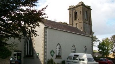
Famine Museum and Granuaile Centre, Louisburgh
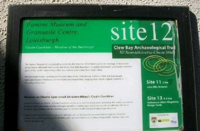
Clew Bay Archeaological Trail site 12
— Slí Seandálaíochta Chuan Módh —
Inscription.
Cluain Cearbhán - Meadow of the Buttercups
The Famine Museum in Louisburgh recounts local memories of the famine, presents coverage of the famine in the media, nationally and locally, and shows how links have been established between Louisburgh and other parts of the world, culminating in the local famine walk along Doo Lough Valley.
The Granuaile Centre recounts the life and times of the 16th century O'Malley Chief and Sea Captain, Granuail (Grace O'Malley or Gráinne Uaile) who headed the shipping fleet which reigned supreme in Clew Bay at that time.
Músaem an Ghorta agus lonad Ghráinne Mhaoil, Cluain Cearbhán
Déanann Músaem an Ghorta i gCluain Cearbhán cur síos ar na cuimhní áitiúla atá ar an nGorta Mór, cuirtear an trácht a bhí ar an nGorta sna meáin, go náisiúnta agus go háitiúil, i láthair agus taipeántar mar a bunaíodh naisc idir Cluain Cearbhán agus codanna eile den domhan, agus tá siúlóid ar feadh Ghleann Dhúloch mar chríoch air.
Tugann lonad Ghráinne Uaile cuntas ar an saol mar a bhí sa 16ú haois le linn ré an Taoisigh agus an Chaptaen Loinge Gráinne Uaile (nó Gráinne Ní Mháille) a bhí i gceann feadhna ar chabhlach long a raibh ceannas ceann acu i gCuan Mó ag an am.
Erected by Mayo County Council, South West Mayo, and Comhoail Oileáin na hÉireann.
Topics. This historical marker is listed in these topic lists: Civil Rights • Disasters • Environment • Waterways & Vessels.
Location. 53° 45.839′ N, 9° 48.58′ W. Marker is in Louisburg, Connacht, in County Mayo. Marker is on Church Road, 0.1 kilometers west of Long Street / Bridge Street (Road R335), on the left when traveling west. Touch for map. Touch for directions.
Other nearby markers. At least 8 other markers are within 11 kilometers of this marker, measured as the crow flies. Lime Kiln, Moneen, (approx. 1.8 kilometers away); Srahwee or Altóir Megalithic Wedge Tomb (approx. 6.5 kilometers away); Bunlahinch Clapperbridge (approx. 7.3 kilometers away); Killeen Graveyard and Cross Slab (approx. 7.4 kilometers away); 1849 Famine Walk (approx. 11 kilometers away); Murrisk Abbey / National Famine Monument / Statue of St Patrick (approx. 11.3 kilometers away); National Famine Memorial (approx. 11.3 kilometers away); Murrisk Friary / Mainistir Mhuraisce (approx. 11.4 kilometers away).
Also see . . . Clew Bay Archaeological Trail. (Submitted on February 28, 2010, by William Fischer, Jr. of Scranton, Pennsylvania.)
Credits. This page was last revised on June 16, 2016. It was originally submitted on February 28, 2010, by William Fischer, Jr. of Scranton, Pennsylvania. This page has been viewed 2,094 times since then and 34 times this year. Photos: 1, 2. submitted on February 28, 2010, by William Fischer, Jr. of Scranton, Pennsylvania.

