Fonthill in Niagara-on-the-Lake in Niagara Region, Ontario — Central Canada (North America)
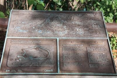
The Treacherous River Cliff
Battle of Queenston Heights Walking Tour
⎯⎯⎯
La falaise traîtresse
Sentier auto-guidé de la bataille de Queenston
Photographed by Dale K. Benington, July 27, 2011
1. The Treacherous River Cliff Marker
View of the plaque on the top of the historical monument.

An unguarded trail up this steep cliff was the only route which the Americans had to the heights of Queenston. The trail was to your right but does not exist any longer.
Trapped on the river shore by unrelenting gunfire, the Americans contemplated a desperate action: the ascent of this cliff. The British, positioned on a ledge (between here and the village of Queenston) did not detect the movement and the attackers took the heights by surprise.
However, later in the battle this cliff became a cruel barrier between the Americans and safety on the other shore.
Les soldats américains sont coincés contre le bas de la falaise par un feu nourri. Ils se dêcident à une action désespérée: l'escalade de cette muraille. Les Britanniques, qui avaient pris position sur une corniche (entre ici et le village de Queenston), ne voient pas la manoeuvre. Les Américains envahissent les hauteurs par surprise.
Mais à la fin
this page online
Erected by Parks Canada. (Marker Number 2.)
Topics. This historical marker is listed in these topic lists: Colonial Era • Indigenous Peoples and Communities • War of 1812. A significant historical date for this entry is October 13, 1812.
Location. 43° 9.637′ N, 79° 2.918′ W. Marker is in Niagara-on-the-Lake, Ontario, in Niagara Region. It is in Fonthill. It is on Niagara River Parkway, on the right when traveling north. The marker is just east of Queenston Heights Park, 15 metres east of the road, on a walking path that leads down the escarpment. Touch for map. Marker is at or near this postal address: 14276 Niagara River Pkwy, Niagara-on-the-Lake ON L0S 1J0, Canada. Touch for directions.

Regionally, this marker is on the Golden Horseshoe and in Niagara Canada. It is also in Central Canada. Globally, it is in North America, on the Great Lakes, in the Western Hemisphere, in the Western World, and in the Anglosphere. Historically, it finds itself in what was once a British colony, the Viceroyalty of New France, the Haudenosaunee

Photographed by Dale K. Benington, July 27, 2011
2. The Treacherous River Cliff Marker
Other nearby markers. At least 8 other markers are within walking distance of this marker: Roy Terrace (about 90 meters away, measured in a direct line); The Niagara Escarpment (about 150 meters away); Chloe Cooley (about 180 meters away); Laura Ingersoll Secord (about 210 meters away); Site of Redan Battery (about 210 meters away); Attack / L'attaque (about 210 meters away); The Capture of the Redan and the Death of Brock (about 210 meters away); Brock's Monument (approx. 0.3 kilometers away). Touch for a list and map of all markers in Niagara-on-the-Lake.
Related markers. Click here for a list of markers that are related to this marker. To better understand the relationship, study each marker in the order shown.
Photographed by Dale K. Benington, July 27, 2011
3. The Treacherous River Cliff Marker
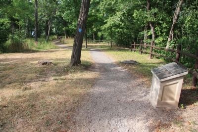
View of the historical marker looking north along the Battle of Queenston Heights walking tour pathway.
Credits. This page was last revised on November 10, 2025. It was originally submitted on January 14, 2012, by Dale K. Benington of Toledo, Ohio. This page has been viewed 1,034 times since then and 27 times this year. Last updated on August 19, 2025, by Kevin Westell of St. Catharines, Ontario. Photos: 1, 2, 3. submitted on January 15, 2012, by Dale K. Benington of Toledo, Ohio. • Devry Becker Jones was the editor who published this page.
