
Grimsby in Niagara Region, Ontario — Central Canada (North America)
Forty Mile Creek
Photographed by Tim Boyd, September 28, 2023
1. Forty Mile Creek Marker
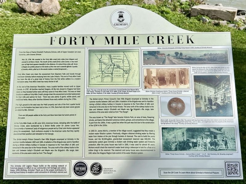
From the Diary of Dame Elizabeth Posthuma Simcoe, wife of Upper Canada's 1st Lieut. Governor, John Graves Simcoe:
May 18, 1794. We coasted to the Forty Mile creek forty miles from Niagara and passed in at three o’clock. The mouth of this creek forms a fine scene; a very bold spur of high land appears beautiful in the distance. It is about three miles off. Some cottages are prettily placed on the banks of the river and a sawmill provides a quality of boards, which, piled up in the woods makes a varied foreground…
Forty Mile Creek runs down the escarpment from Beamers Falls and travels through downtown Grimsby before emptying here into Lake Ontario. This end of Forty Mile Creek has been the site of a great deal of history from the first white settlers to a modern recreation area; Forty Mile Creek has many stories to tell.
At the end of the American Revolution, many Loyalist families moved north to Upper Canada. In 1787, 46 families reached Niagara. All the lots closest to Niagara had been taken so they traveled further west und they came to Forty Mile Creek. This was an ideal location to settle as Forty Mile
this page online
The high ground to the west was the Pettit property and site of the first Loyalist burial ground, but its location has been lost to time. In 1794, there had only been seven graves as stated by Mrs. Simcoe:
There are 100 people settled at the Forty and there have been but seven graves in five yearsAt the Forty Mile Creek, on 8th June 1813, American forces, retreating after the battle of Stoney Creek, were bombarded by a British flotilla under Sir James Lucas Yeo. Concurrently a “numerous" party of Indigenous people led by Chief John Norton appeared along the escarpment. Such confusion erupted in the American ranks that they rapidly abandoned their position and retreated to Fort George.
The British Army's Prince Consort’s Own Rifle Brigade encamped at Grimsby in the summer months between 1862 and 1864. A battalion of the Brigade was sent to Hamilton during a British military buildup in Canada in
Photographed by Tim Boyd, September 28, 2023
2. Forty Mile Creek Marker
The British Army's Prince Consort’s Own Rifle Brigade encamped at Grimsby in the summer months between 1862 and 1864. A battalion of the Brigade was sent to Hamilton during a British military buildup in Canada in response to the Trent Affair of 1861 and remained in the area due to the Fenian threats. The area north of the railway tracks to the lake and between today's Elizabeth and Maple was the Brigade's rifle range, later residents of the area were noted as from "The Range".
The area known as "The Range“ later became Victoria Park, an area of trees, flowering shrubs, and lawns that attracted numerous visitors, groups, and conventions to the village. A park from the 1890s, it was a great loss when the park was lost due to the construction of the QEW in the 1930s.
In 1905 Dr. James Morris, a member of the village council, suggested that they create a modern water filtration system. Previously, villagers obtained drinking water by filtering water from intakes at the pier through buckets of charcoal. The cost to build the pump house, and the 90,000-gallon, gravity-feed escarpment reservoir was $40,000. The waterworks system gave Grimsby a modern safe drinking water system and fireworks protection. After the pump house was built in 1905, it was used for almost 80 years. Workers would check the reservoirs water level using a telescope to look for a float on a rubber dingy in the reservoir. The reservoir and pump house were decommissioned in 1981 when the Niagara Region took control of the water filtration system.
This Grimsby 100 Legacy Plaque builds on the existing network of historical plaques to reflect on our community's rich heritage and culture. Happy 100th Birthday, Grimsby! Thank you to the project contributors for sharing local history to enable a sold connection to Grimsby’s storied past.
Erected 2022 by Grimsby Historical Society.
Topics. This historical marker is listed in these topic lists: Colonial Era • Settlements & Settlers • War of 1812 • Waterways & Vessels. A significant historical year for this entry is 1784.
Location. 43° 12.267′ N, 79° 33.181′ W. Marker is in Grimsby, Ontario, in Niagara Region. It can be reached from Elizabeth Street 0.1 kilometers north of Lakeside Drive, on the left when traveling east. The marker is in the Grimsby 1812 Bicentennial Peace Garden, near the former Pumphouse at the end of Elizabeth Street, less than 100 metres from the intersection of Lakeside Drive. It is accesible from the parking lot. Touch for map. Marker is at or near this postal address: 447 Elizabeth St, Grimsby ON L3M 3K8, Canada. Touch for directions.

Regionally, this marker is on Ontario’s Golden Horseshoe and in Niagara Canada. It is also in Central Canada. Globally, it is in North America, on the Great Lakes, in the Western Hemisphere, in the Western World, and in the Anglosphere. Historically, it finds itself in what was once a British colony, the Viceroyalty of New France, the Haudenosaunee (Iroquois) Confederacy, and Rupert’s Land.
Other nearby markers. At least 8 other markers are within walking distance of this marker: Grimsby 1812 Bicentennial Flagpole (here, next to this marker); Engagement at the Forty: June 8, 1813 (a few steps from this marker); Grimsby 1812 Bicentennial Gazebo (a few steps from this marker); Fisheries in Grimsby (within shouting distance of this marker); Engagement at the Forty Mile Creek / L'Engagement de Forty Mile Creek (within shouting distance of this marker); Carnegie Library 1912 (approx. 1.2 kilometers away); Delmer William Lord (approx. 1.4 kilometers away); Canadian Bank of Commerce - Established 1922 (approx. 1.4 kilometers away). Touch for a list and map of all markers in Grimsby.
Credits. This page was last revised on September 30, 2025. It was originally submitted on October 1, 2023, by Tim Boyd of Hamilton, Ontario. This page has been viewed 2,275 times since then and 147 times this year. Last updated on September 8, 2025, by Kevin Westell of St. Catharines, Ontario. Photos: 1, 2. submitted on October 1, 2023, by Tim Boyd of Hamilton, Ontario. • Devry Becker Jones was the editor who published this page.
