Denali National Park and Preserve in Denali Borough, Alaska — Northwest (North America)
The Language of the Land
Denali National Park and Preserve
| — | National Park Service, U.S. Department of the Interior | — |
Photographed by Thomas Smith
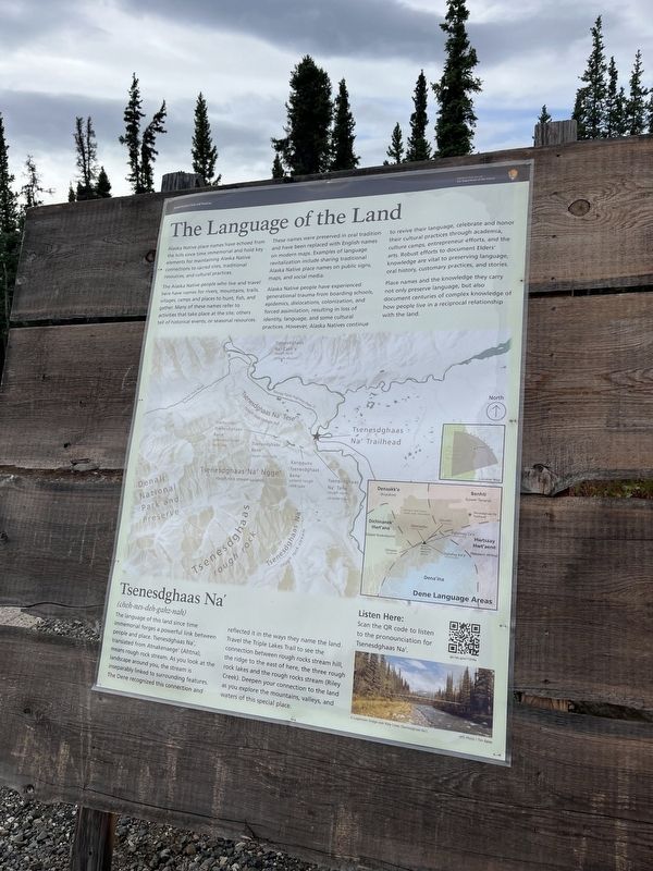
1. The Language of the Land Marker
Alaska Native place names have echoed from the hills since time immemorial and hold key elements for maintaining Alaska native connection to sacred sites, traditional resources, and cultural practices.
The Alaska Native people who live and travel here have name for rivers, mountain, trails, villages, camps and places to hunt, fish, and gather. many of these names refer to activities that take place at the site; others tell of historical events, or seasonal resources.
These names were preserved in oral tradition and have been replaced with English names on modern maps. Example of language revitalization include sharing traditional Alaska Native place names on public signs, maps, and social media.
Alaska Native people have experienced generational trauma from boarding schools, epidemics, dislocations, colonization, and force assimilation, resulting in loss of identity, language, and some culture practices. However, Alaska natives continue to revive their language, celebrate and honor their cultural practices through academia, culture camps, entrepreneur efforts, and the arts. robust efforts to document Elders'
this page online
Place names and the knowledge they carry not only preserve language, but also document centuries of complex knowledge of how people live in a reciprocal relationship with the land.
[Sidebar:]
Tsenesdghaas Na'(cheh-nes-deh-gahz-nah)
The language of this land since time immemorial forges a powerful link between people and place. Tsenesdghaas Na' translated from Atnakenaege' (Ahtna) means rough rock steam. As you look at the landscape around you, the stream is inseparably linked to surrounding features. The Dene recognized this connection and reflected it in the ways they name the land. Travel the Tripple lake trail to see the connection between rough rocks stream hill, the ridge to the east of here , the three rough rock lakes and tge rough rock steam (Riley Creek). Deepen your connection to the land as you explore the mountains, valley and waters of this special place.
Erected by National Park Service, U.S. Department of the Interior.
Topics. This historical marker is listed in these topic lists: Anthropology & Archaeology • Communications • Environment • Indigenous Peoples and Communities.
Location. 63° 39.442′ N, 148° 50.207′ W. Marker is in Denali National Park and Preserve, Alaska, in Denali Borough. It is on Parks Highway one mile Old Parks Hwy, on the right when traveling north. Touch for map. Marker is at or near this postal address: 231 Parks Highway, Healy AK 99743, United States of America. Touch for directions.

Regionally, this marker is in the Alaska Railroad Corridor, in the Athabascan Region, and in Interior Alaska. It is also on the American Pacific Coast. Globally, it is in North America, on the Pacific Rim, in the Western Hemisphere, in the Western World, and in the Anglosphere. Historically, it finds itself in what was once the Russian Empire.
Other nearby markers. At least 8 other markers are within 6 miles of this marker, measured as the crow flies: Tunnels Lost to Time (approx. 5.6 miles away); The Ties That Bind (approx. 5.6 miles away); Bridging the Gaps (approx. 5.6 miles away); At Ease (approx. 5.6 miles away); The Station Through Time (approx. 5.6 miles away); Meet the Neighbors (approx. 5.6 miles away); The Time-Honored Trail (approx. 5.6 miles away); The Park Hotel (approx. 5.7 miles away). Touch for a list and map of all markers in Denali National Park and Preserve.
Credits. This page was last revised on October 10, 2025. It was originally submitted on September 14, 2025, by Thomas Smith of Waterloo, Ill. This page has been viewed 72 times since then and 25 times this year. Photo 1. submitted on September 14, 2025, by Thomas Smith of Waterloo, Ill. • Devry Becker Jones was the editor who published this page.
