East Dover Hundred in Kent County, Delaware — The American Northeast (Mid-Atlantic)
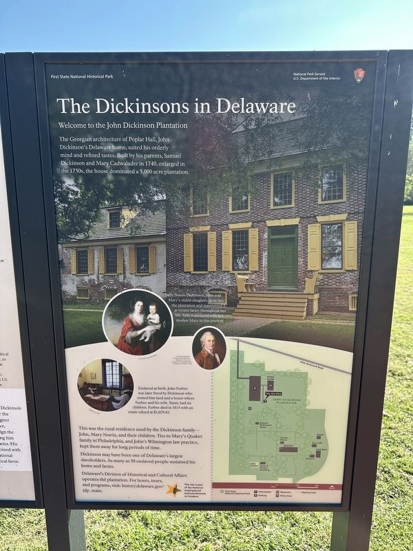
The Dickinsons in Delaware
Welcome to the John Dickinson Plantation
| — | First State National Historical Park, National Park Service, U.S. Department of the Interior | — |
Photographed by Pete Skillman, September 23, 2025
1. The Dickinsons in Delaware Marker
The Georgian Architecture of Poplar Hall, John Dickinson's Delaware home, suited his orderly mind and refined tastes. Built by his parents, Samuel Dickinson and Mary Cadwalader in 1740, enlarged in the 1750s, the house dominated a 5,000 acre plantation.
This was the rural residence used by the Dickinson family -- John, Mary Norris, and their children. Ties to Mary's Quaker family in Philadelphia, and John's Wilmington law practice, kept them away for long periods of time.
Dickinson may have been one of Delaware's largest slaveholders. As many as 58 enslaved people sustained his home and farms.
Delaware's Division of Historical and Cultural Affairs operates the plantation. For hours, tours, and programs, visit: history.delaware.gov/jdp_main.
(Captions):
Sally Norris Dickinson, John and Mary's oldest daughter, inherited the plantation and maintained it as tenant farms throughout her life. Sally is pictured with her mother Mary in this portrait. By Charles Willson Peale
John Dickinson by Charles Willson Peale, from life, 1782-1783, Courtesy of Independence National Historical Park.
Enslaved at birth,
this page online
This site is part of the National Underground Railroad Network to Freedom.
Erected 2024 by National Park Service, U.S. Department of the Interior.
Topics and series. This historical marker is listed in these topic lists: Abolition & Underground RR • Agriculture • Colonial Era • Settlements & Settlers. In addition, it is included in the Network to Freedom series list. A significant historical year for this entry is 1740.
Location. 39° 6.157′ N, 75° 26.949′ W. Marker is near Dover, Delaware, in Kent County. It is in East Dover Hundred. It can be reached from Kitts Hummock Road. Touch for map. Marker is at or near this postal address: 318 Kitts Hummock Rd, Dover DE 19901, United States of America. Touch for directions.

Regionally, this marker is in the American Mid-Atlantic, on the Delmarva Peninsula, and on the Eastern Seaboard. Globally, it is in the North Atlantic Region, North America, the Western Hemisphere, the Western World,

Photographed by Pete Skillman, September 23, 2025
2. The Dickinsons in Delaware Marker - wide view
Other nearby markers. At least 8 other markers are within one mile of this marker, measured as the crow flies: Toward a Future Union (here, next to this marker); The St. Jones River: Why the Mansion Faces South (about 700 feet away, measured in a direct line); Home of John Dickinson (about 700 feet away); St. Jones Neck (approx. 0.4 miles away); C-45G (approx. 1.1 miles away); C-60 (approx. 1.1 miles away); U-3A (approx. 1.1 miles away); LGM-30 (approx. 1.1 miles away). Touch for a list and map of all markers in Dover.
Also see . . . John Dickinson Plantation - Delaware Historical and Cultural Affairs. This is the website mentioned in the text of the marker, however, the URL given in the text no longer works.
The John Dickinson Plantation was home to a variety of people. We share the stories of the tenant farmers, indentured servants, free and enslaved Black men, women, and children who lived, labored, and died on the plantation. John Dickinson was a framer and signer(Submitted on September 23, 2025, by Pete Skillman of Wilmington, Delaware.)of the U.S. Constitution and was known as the “Penman of the Revolution.” He was an American founding father, who wrote of freedom and liberty for all while holding human beings in bondage.Photographed by Pete Skillman, September 23, 20253. The Dickinsons in Delaware Marker - 3D accessible map of the property

Credits. This page was last revised on May 15, 2026. It was originally submitted on September 23, 2025, by Pete Skillman of Wilmington, Delaware. This page has been viewed 100 times since then and 43 times this year. Photos: 1, 2, 3. submitted on September 23, 2025, by Pete Skillman of Wilmington, Delaware.
