Township of Trescott near Lubec in Washington County, Maine — The American Northeast (New England)
Pike Lands Cove
Photographed by Steve Stoessel, October 2, 2025
1. Pike Lands Cove Marker
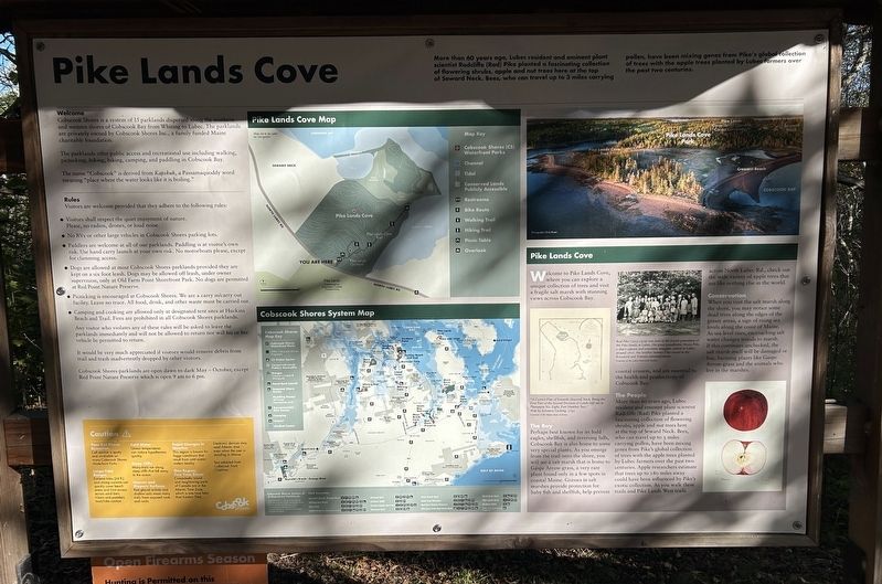
More than 60 years ago, Lubec resident and eminent plant Radcliffe (Rad) Pike planted a fascinating collection ring shrubs, apple and nut trees here at the top Steward Neck. Bees, who can travel up to 3 miles carrying pollen, have been mixing genes from Pike's global collection of trees with the apple trees planted by Lubec farmers over the past two centuries.
Welcome
Cobscook Shores is a system of 15 parklands dispersed along the southern and western shores of Cobscook Bay from Whiting to Lubec. The parklands are privately owned by Cobscook Shores Inc., a family funded Maine charitable foundation.
The parklands offer public access and recreational use including walking, picnicking, hiking, biking, camping, and paddling in Cobscook Bay.
The name "Cobscook" is derived from Kapskuk, a Passamaquoddy word meaning "place where the water looks like it is boiling."
Pike Lands Cove
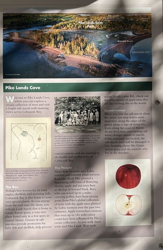
Welcome to Pike Lands Cove, where you can explore a unique collection of trees and visit a fragile salt marsh with stunning views across Cobscook Bay.
"A Correct Plan of Sowards /Seward) Neck, Being the First Part of the Second Division of Lands laid out in Plantation No. Eight, Part Number Two." Map by Solomon Cushing, 1795
The Bay
Perhaps
this page online
Rad Pike (2903-1979) was part of the fourth generation of the Pike family in Lubec. His great grandfather Moses Pike. a ship's captain and sometime smuggler, settled in Luber around 7816. His brother Summer Pike served in the Roosevelt and Truman administrations.
The People
More than 60 years ago, Lubec resident and eminent plant scientist Radcliffe (Rad) Pike planted a fascinating collection of flowering shrubs, apple and nut trees here at the top of Seward Neck. Bees, who can travel up to 3 miles carrying pollen, have been mixing genes from Pike's global collection of trees with the apple trees planted by Lubec farmers over the past two centuries. Apple researchers estimate that
Photographed by Steve Stoessel, October 2, 2025
2. Pike Lands Cove Marker
Conservation
When you visit the salt marsh along the shore, you may notice some dead trees along the edges of the grassy areas, a sign of rising sea levels along the coast of Maine. As sea level rises, encroaching salt water changes woods to marsh. If this continues unchecked, the salt marsh itself will be damaged or lost, harming plants like Gaspe Arrow-grass and the animals who live in the marshes.
[ Rules, Cautions, and Maps were not transcribed ]
Erected by Cobscook Shores.
Topics. This historical marker is listed in these topic lists: Agriculture • Environment • Horticulture & Forestry • Parks & Recreational Areas. A significant historical year for this entry is 1795.
Location. 44° 53.988′ N, 67° 3.074′ W. Marker is near Lubec, Maine, in Washington County. It is in Township of Trescott. It can be reached from North Lubec Road 5.1 miles north of Maine Route 189, on
Photographed by Steve Stoessel, October 2, 2025
3. Pike Lands Cove Marker

Regionally, this marker is in Downeast Maine. It is also in the American Northeast, in New England, and on the Eastern Seaboard. Globally, it is in the North Atlantic Region, North America, the Great North Woods, the Western Hemisphere, the Western World, and the Anglosphere. Historically, it finds itself in what was once the Viceroyalty of New France and also Acadia.
Other nearby markers. At least 8 other markers are within 3 miles of this marker, measured as the crow flies: U.S.S. Richmond (approx. 1.9 miles away); USS Wabash / USS Franklin (approx. 1.9 miles away); Civil War Ships Burned at Cony Beach (approx. 1.9 miles away); Civil War Ships on Cony Beach (approx. 1.9 miles away); U.S.S. Minnesota / U.S.S. Vermont (approx. 1.9 miles away); Aquaculture’s Place in a Working Harbor (approx. 1.9 miles away); The Tumultuous History of Cony Park (approx. 2 miles away); Arthur Smallidge Campground (approx. 2.3 miles away).
Credits. This page was last revised on October 10, 2025. It was originally submitted on October 9, 2025, by Steve Stoessel of Niskayuna, New York. This page has been viewed 51 times since then and 16 times this year. Photos: 1. submitted on October 9, 2025, by Steve Stoessel of Niskayuna, New York. 2, 3. submitted on October 10, 2025, by Steve Stoessel of Niskayuna, New York.
