Holly in Prowers County, Colorado — The American Mountains (Southwest)
Arkansas River
Photographed by Cosmos Mariner, July 25, 2023
1. Arkansas River Marker
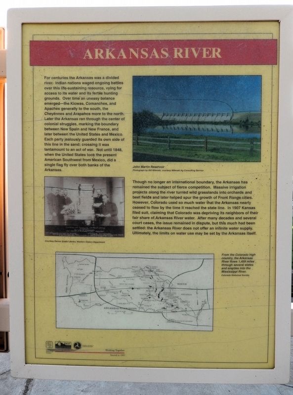
For centuries the Arkansas was a divided river. Indian nations waged ongoing battles over this life-sustaining resource, vying for access to its water and its fertile hunting grounds. Over time an uneasy balance emerged — the Kiowas, Comanches„ and Apaches generally to the south, the Cheyennes and Arapahos more to the north. Later the Arkansas ran through the center of colonial struggles, marking the boundary between New Spain and New France, and later between the United States and Mexico. Each party jealously guarded its own side of this line in the sand; crossing it was tantamount to an act of war. Not until 1848, when the United States took the present American Southwest from Mexico, did a single flag fly over both banks of the Arkansas.
Though no longer an international boundary, the Arkansas has remained the subject of fierce competition. Massive irrigation projects along the river turned wild grasslands into orchards and beet fields and later helped spur the growth of Front Range cities. However, Colorado used so much water that the Arkansas nearly ceased to flow by the time it reached the state line. In 1907 Kansas
this page online
From the Colorado high country, the Arkansas River flows 1,459 miles through several states and empties into the Mississippi River.
[photo captions]
• John Martin Reservoir
• Arkansas River Basin Map
Erected 1997 by Colorado Historical Society, Colorado Department of Transportation, and Federal Highway Administration.
Topics and series. This historical marker is listed in these topic lists: Colonial Era • Indigenous Peoples and Communities • War, Mexican-American • Waterways & Vessels. In addition, it is included in the History Colorado series list. A significant historical year for this entry is 1848.
Location. 38° 2.966′ N, 102° 3.085′ W. Marker is in Holly, Colorado, in Prowers County. It can be reached from Santa Fe Trail Scenic Byway (U.S. 50/400 at milepost 467.4), half a

Photographed by Cosmos Mariner, July 25, 2023
2. Arkansas River Marker
This marker is the rightmost of two panels on the north side of this Colorado interpretive kiosk. The Colorado Department of Transportation Holly Rest Stop parking lot is in the background.

Regionally, this marker is in the Eastern Plains. It is also in the American Mountain West, on the Great Plains, on the Southern Plains, on the High Plains, and on the Santa Fe Trail Corridor. Globally, it is in North America, the Western Hemisphere, the Western World, and the Anglosphere. Historically, it finds itself in what was once New Spain, the Comanchería, the Dust Bowl, and the Republic of Texas.
Other nearby markers. At least 4 other markers are within 3 miles of this marker, measured as the crow flies: Trail City (here, next to this marker); Santa Fe Trail Scenic and Historic Byway — Colorado (here, next to this marker); Explore Santa Fe Trail History (a few steps from this marker); Santa Fe Trail (approx. 2½ miles away in Kansas).
Also see . . . Arkansas River (Wikipedia).
Excerpt: The Arkansas River generally flows to the east and southeast as it traverses the U.S. states of Colorado, Kansas, Oklahoma, and Arkansas. The river's source basin lies in Colorado, specifically the Arkansas River Valley. The headwaters derive from the snowpack in the Sawatch and Mosquito mountain ranges. It flows east into Kansas and finally through Oklahoma and Arkansas, where it meets the Mississippi River. At 1,469 miles it is the sixth-longest river in the United States, the second-longest tributary in the Mississippi–Missouri system, and the 47th longest river in the world. Its origin is in the Rocky Mountains in Lake County, Colorado, near Leadville.(Submitted on December 5, 2025, by Cosmos Mariner of Cape Canaveral, Florida.)Many nations of Native Americans lived near, or along, the Arkansas River for thousands of years. The first Europeans to see the river were members of the Spanish Coronado expedition on June 29, 1541. Also in the 1540s, Hernando de Soto discovered the junction of the Arkansas with the Mississippi. In 1819, the Adams–Onís Treaty set the Arkansas as part of the frontier between the United States and Spanish Mexico. This continued until the United States annexed Texas after the Mexican–American War, in 1846.
Credits. This page was last revised on December 5, 2025. It was originally submitted on December 3, 2025, by Cosmos Mariner of Cape Canaveral, Florida. This page has been viewed 97 times since then and 54 times this year. Photos: 1, 2. submitted on December 5, 2025, by Cosmos Mariner of Cape Canaveral, Florida.
