Near Dolores in Montezuma County, Colorado — The American Mountains (Southwest)
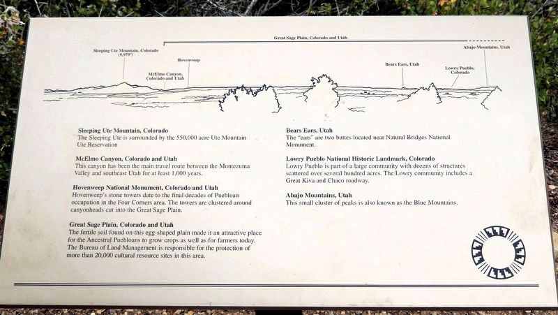
Great Sage Plain, Colorado and Utah
Photographed by Cosmos Mariner, July 17, 2025
1. Great Sage Plain, Colorado and Utah Marker
Sleeping Ute Mountain, Colorado
The Sleeping Ute is surrounded by the 550,000 acre Ute Mountain Ute Reservation.
McElmo Canyon, Colorado and Utah
This canyon has been the main travel route between the Montezuma Valley and southeast Utah for at least 1,000 years.
Hovenweep National Monument, Colorado and Utah
Hovenweep's stone towers date to the final decades of Puebloan occupation in the Four Corners area. The towers are clustered around canyonheads cut into the Great Sage Plain.
Great Sage Plain, Colorado and Utah
The fertile soil found on this egg-shaped plain made it an attractive place for the Ancestral Puebloans to grow crops as well as for farmers today. The Bureau of Land Management is responsible for the protection of more than 20,000 cultural resource sites in this area.
Bears Ears, Utah
The “ears” are two buttes located near Natural Bridges National Monument.
Lowry Pueblo National Historic Landmark, Colorado
Lowry Pueblo is part of a large community with dozens of structures scattered over several hundred acres. The Lowry community includes a Great Kiva and Chaco roadway.
Abajo Mountains, Utah
This small cluster of peaks
this page online
Erected by The Colorado Historical Society, the Bureau of Land Management, the Family of Nellie Mulnix Joy and the Frankston Family.
Topics. This historical marker is listed in these topic lists: Agriculture • Anthropology & Archaeology • Indigenous Peoples and Communities.
Location. 37° 28.738′ N, 108° 32.807′ W. Marker is near Dolores, Colorado, in Montezuma County. It can be reached from State Highway 184 at milepost 7, on the right when traveling west. The marker is on the Escalante Pueblo Trail at the Canyons of the Ancients National Monument Visitor Center. Touch for map. Marker is at or near this postal address: 27501 Colorado Highway 184, Dolores CO 81323, United States of America. Touch for directions.

Regionally, this marker is in the American Mountain West, on the Colorado Plateau, and at the Four Corners. Globally, it is in North America, the Rocky Mountains, the Western Hemisphere, the Western World, and the Anglosphere. Historically, it finds itself in what was once the territory of the Ancestral Puebloans
Photographed by Cosmos Mariner, July 17, 2025
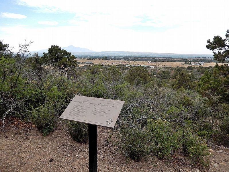
2. Great Sage Plain, Colorado and Utah Marker
Looking west; Sleeping Ute Mountain is visible in the distant left background.
Other nearby markers. At least 8 other markers are within walking distance of this marker: Farmland... Now & Then (a few steps from this marker); The Making of a Mountain (within shouting distance of this marker); Juniper (within shouting distance of this marker); Big Bend & McPhee (within shouting distance of this marker); Dolores / McPhee Reservoir (within shouting distance of this marker); Piñon (within shouting distance of this marker); Wildlife or Relatives? (about 300 feet away, measured in a direct line); Prickly Pear Cactus (about 300 feet away). Touch for a list and map of all markers in Dolores.
Related markers. Click here for a list of markers that are related to this marker.
Also see . . . Cultural Heritage of the Great Sage Plain (Archaeology Channel ).
Excerpt: Surrounded by snow-capped mountains, a vast plateau streaked with numerous canyons stretches from Cortez, Colorado, northwestward into Utah. A productive agricultural region today, the Great Sage Plain displays numerous ruins of an ancient civilization that puzzled the earliest European explorers but echoes today in its living Native American descendants. For the past hundred years, archaeologists and Native people have collaborated to paint the picture and tell the story of the vibrant culture that once thrived here.(Submitted on December 23, 2025, by Cosmos Mariner of Cape Canaveral, Florida.)
Credits. This page was last revised on December 23, 2025. It was originally submitted on December 21, 2025, by Cosmos Mariner of Cape Canaveral, Florida. This page has been viewed 67 times since then and 27 times this year. Photos: 1, 2. submitted on December 23, 2025, by Cosmos Mariner of Cape Canaveral, Florida.
