Near St. Francisville in Clark County, Missouri — The American Midwest (Upper Plains)
The Illinois in History
Photographed by Connor Olson, October 17, 2025
1. The Illinois in History Marker
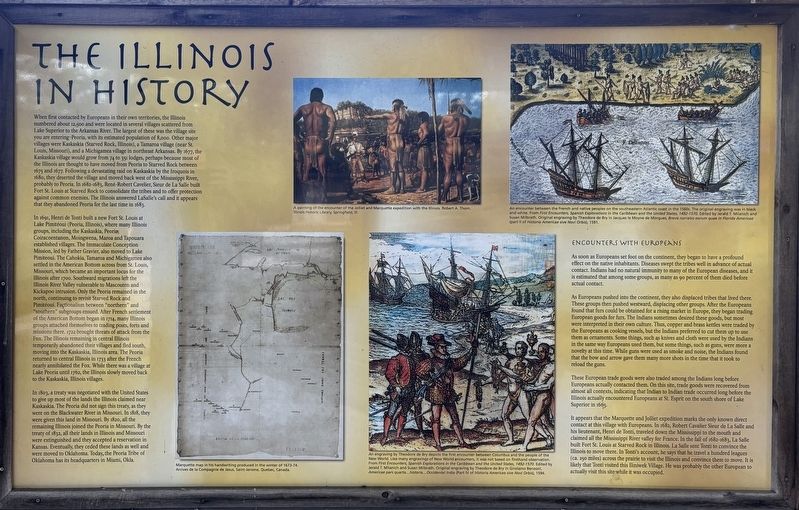
When first contacted by Europeans in their own territories, the Illinois numbered about 12,500 and were located in several villages scattered from Lake Superior to the Arkansas River. The largest of these was the village site you are entering-Peoria, with its estimated population of 8,000. Other major villages were Kaskaskia (Starved Rock, Illinois), a Tamaroa village (near St. Louis, Missouri), and a Michigamea village in northeast Arkansas. By 1677, the Kaskaskia village would grow from 74 to 350 lodges, perhaps because most of the Illinois are thought to have moved from Peoria to Starved Rock between 1675 and 1677. Following a devastating raid on Kaskaskia by the Iroquois in 1680, they deserted the village and moved back west of the Mississippi River, probably to Peoria. In 1682-1683, René-Robert Cavelier, Sieur de La Salle built Fort St. Louis at Starved Rock to consolidate the tribes and to offer protection against common enemies. The Illinois answered LaSalle's call and it appears that they abandoned Peoria for the last time in 1683.
In 1691, Henri de Tonti built a new Fort St. Louis at Lake Pimitéoui (Peoria,
this page online
Photographed by Connor Olson, October 17, 2025
2. The Illinois in History Marker
In 1803, a treaty was negotiated with the United States to give up most of the lands the Illinois claimed near Kaskaskia. The Peoria did not sign this treaty, as they were on the Blackwater River in Missouri. In 1818, they were given this land in Missouri. By 1820, all the remaining Illinois joined the Peoria in Missouri. By the treaty of 1832, all their lands in Illinois and Missouri were extinguished and they accepted a reservation in Kansas. Eventually, they ceded these lands as well and were moved to Oklahoma. Today, the Peoria Tribe of Oklahoma has its headquarters in Miami, Okla.
Encounters with Europeans
As soon as Europeans set foot on the continent, they began to have a profound effect on the native inhabitants. Diseases swept the tribes well in advance of actual contact. Indians had no natural immunity to many of the European diseases, and it is estimated that among some groups, as many as go percent of them died before actual contact.
As Europeans pushed into the continent, they also displaced tribes that lived there. These groups then pushed westward, displacing other groups. After the Europeans found that furs could be obtained for a rising market in Europe, they began trading European goods for furs. The Indians sometimes desired these goods, but most were interpreted in their own culture. Thus, copper and brass kettles were traded by the Europeans as cooking vessels, but the Indians preferred to cut them up to use them as ornaments. Some things, such as knives and cloth were used by the Indians in the same way Europeans used them, but some things, such as guns, were more a novelty at this time. While guns were used as smoke and noise, the Indians found that the bow and arrow gave them many more shots in the time that it took to reload the guns.
These European trade goods were also traded among the Indians long before Europeans actually contacted them. On this site, trade goods were recovered from almost all contexts, indicating that Indian to Indian trade occurred long before the Illinois actually encountered Europeans at St. Esprit on the south shore of Lake Superior in 1665.
It appears that the Marquette and Jolliet expedition marks the only known direct contact at this village with Europeans. In 1682, Robert Cavalier Sieur de La Salle and his lieutenant, Henri de Tonti, traveled down the Mississippi to the mouth and claimed all the Mississippi River valley for France. In the fall of 1682-1683, La Salle built Fort St. Louis at Starved Rock in Illinois. La Salle sent Tonti to convince the Illinois to move there. In Tonti's account, he says that he travel a hundred leagues (ca. 250 miles) across the prairie to visit the Illinois and convince them to move. It is likely that Tonti visited this lliniwek Village. He was probably the other European to actually visit this site while it was occupied.
Erected by Illinois Department of Natural Resources.
Topics. This historical marker is listed in these topic lists: Anthropology & Archaeology • Colonial Era • Exploration • Indigenous Peoples and Communities • Settlements & Settlers. A significant historical year for this entry is 1677.
Location. 40° 25.74′ N, 91° 33.45′ W. Marker is near St. Francisville, Missouri, in Clark County. It can be reached from County Road 188 north of County Road 200, on the right when traveling north. Touch for map. Marker is at or near this postal address: 22569 County Rd 188, Wayland MO 63472, United States of America. Touch for directions.

Regionally, this marker is in North Missouri. It is also in the American Lewis & Clark Corridor, in the Corn Belt, and in the Great River Road Region. Globally, it is in North America, the Western Hemisphere, the Western World, and the Anglosphere. Historically, it finds itself in what was once the territory of the Mississippian Culture, the Louisiana Purchase, and the Antebellum South.
Other nearby markers. At least 8 other markers are within 8 miles of this marker, measured as the crow flies: Marquette and Joliet (here, next to this marker); Origins, Groups, and Encounters (here, next to this marker); Daily Village Life (here, next to this marker); Iliniwek Village State Historic Site (here, next to this marker); Archeology (here, next to this marker); The Longhouse (approx. 0.2 miles away); Fort Edwards (approx. 7.8 miles away in Illinois); Fort Edwards Monument (approx. 7.8 miles away in Illinois). Touch for a list and map of all markers in St. Francisville.
Credits. This page was last revised on December 28, 2025. It was originally submitted on December 27, 2025, by Connor Olson of Menomonee Falls, Wisconsin. This page has been viewed 87 times since then and 63 times this year. Photos: 1, 2. submitted on December 27, 2025, by Connor Olson of Menomonee Falls, Wisconsin. • Devry Becker Jones was the editor who published this page.
Editor’s want-list for this marker. A wide shot of the marker in context. • Can you help?
