Gambles Hill in Richmond, Virginia — The American South (Mid-Atlantic)
Rutherfoord’s Mill
Photographed by Bernard Fisher, November 3, 2009
1. Rutherfoord’s Mill Marker
Topics. This historical marker is listed in these topic lists: Agriculture • Industry & Commerce • Railroads & Streetcars • Waterways & Vessels. A significant historical year for this entry is 1800.
Location. Marker has been permanently removed. It was located near 37° 32.163′ N, 77° 26.754′ W. Marker was in Richmond, Virginia. It was in Gambles Hill. It could be reached from Tredegar Street 0.1 miles west of South 5th Street. This marker is located outside the Civil War Visitor Center at Tredegar Iron Works. Touch for map. Marker was at or near this postal address: 500 Tredegar Street, Richmond VA 23219, United States of America.
We have been informed that
this page online
Regionally, this marker was in Central Virginia. It was also in the American South and specifically in the Upper South. Globally, it was in North America, the Western Hemisphere, the Western World, and the Anglosphere. Historically, it found itself in what was once the territory of the Mississippian Culture, one of the original Thirteen Colonies, one of the Confederate States of America, and the Antebellum South.

Other nearby markers. within walking distance of this location: Touch for a list and map of all markers in Richmond.
Other markers no longer nearby. Cupolas from the Virginia State Penitentiary (was here, next to this marker but has been permanently removed); Tredegar Spike Mill (was a few steps from this marker but has been permanently removed); Raceways (was within shouting distance of this marker but has been permanently removed); Rail Lines at Tredegar (was within shouting distance of this marker but has been permanently removed); The Richmond-Petersburg Railroad Bridge (was within shouting distance
Photographed by Bernard Fisher, November 3, 2009
2. Rutherfoord’s Mill Marker
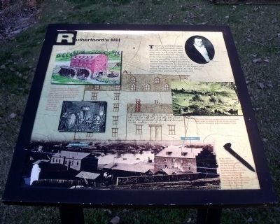
More about this marker. On the left of the panel are a watercolor of the mill and a sketch of coopers making barrels. The caption reads, “The flour mill was only one of several buildings built by Rutherfoord before the Civil War. A corn mill, a cooper’s shop for barrel making, and granaries for storage before milling were built in this vicinity. The quantities of grain produced far surpassed tobacco in the early 1800s, requiring a rapid expansion in transportation, storage, and milling facilities.”
On the upper right is a portrait of Thomas Rutherfoord.
On the right is a drawing of the canal carrying the caption, “The James River and Kanawha Canal not only provided water power for Rutherfoord’s Mill, but also was the conduit for transporting grains from western Virginia.”
On the bottom is a period photograph of the spike mill carrying the caption, “By the 1840s, milling operations had stopped in the flour mill. The Tredegar Iron Works built a spike mill on the earlier foundations in 1859, seen in many photographs taken after the Civil War. Tredegar still used water power from the canal, but made many products for the canal’s direct competitor – railroads.”
Credits. This page was last revised on January 20, 2026. It was originally submitted on November 7, 2009, by Bernard Fisher of Richmond, Virginia. This page has been viewed 965 times since then and 38 times this year. Last updated on January 19, 2026, by Evan Dwyer of Richmond, Virginia. Photos: 1, 2. submitted on November 7, 2009, by Bernard Fisher of Richmond, Virginia. • Devry Becker Jones was the editor who published this page.
