Haven Township near St. Cloud in Sherburne County, Minnesota — The American Midwest (Upper Plains)
Historic Wayside
⎯⎯⎯
Maintaining Our Natural Heritage
Photographed by McGhiever, November 3, 2022
1. Historic Wayside Marker
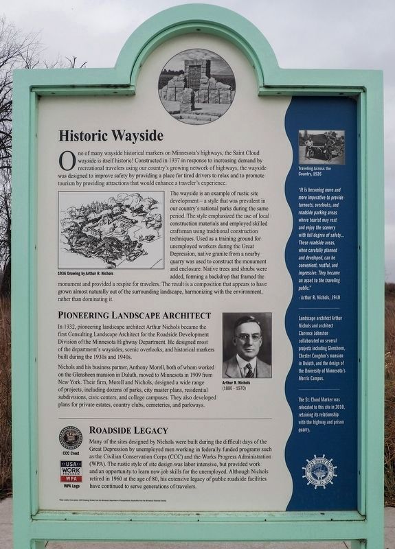
Historic Wayside
One of many wayside historical markers on Minnesota's highways, the Saint Cloud wayside is itself historic! Constructed in 1937 in response to increasing demand by recreational travelers using our country's growing network of highways, the wayside was designed to improve safety by providing a place for tired drivers to relax and to promote tourism by providing attractions that would enhance a traveler's experience.
1936 Drawing by Arthur R. Nichols
The wayside is an example of rustic site development—a style that was prevalent in our country's national parks during the same period. The style emphasized the use of local construction materials and employed skilled craftsman [sic] using traditional construction techniques. Used as a training ground for unemployed workers during the Great Depression, native granite from a nearby quarry was used to construct the monument and enclosure. Native trees and shrubs were added, forming a backdrop that framed the monument and provided a respite for travelers. The result is a composition that appears to have grown almost naturally out of the surrounding landscape,
this page online
Pioneering Landscape Architect
In 1932, pioneering landscape architect Arthur Nichols became the first Consulting Landscape Architect for the Roadside Development Division of the Minnesota Highway Department. He designed most of the department's waysides, scenic overlooks, and historical markers built during the 1930s and 1940s.
Arthur R. Nichols
(1880 - 1970)
Nichols and his business partner, Anthony Morell, both of whom worked on the Glensheen mansion in Duluth, moved to Minnesota in 1909 from New York. Their firm, Morell and Nichols, designed a wide range of projects, including dozens of parks, city master plans, residential subdivisions, civic centers, and college campuses. They also developed plans for private estates, country clubs, cemeteries, and parkways.
Roadside Legacy
CCC Crest
WPA Logo
Many of the sites designed by Nichols were built during the difficult days of the Great Depression by unemployed men working in federally funded programs such as the Civilian Conservation Corps (CCC) and the Works Progress Administration (WPA). The rustic style

Photographed by McGhiever, November 3, 2022
2. Maintaining Our Natural Heritage Marker
Photo credits: Circle photo, 1936 Drawing, Nichols from the Minnesota Department of Transportation; Automobile from the Minnesota Historical Society.
Traveling Across the Country, 1926
"It is becoming more and more imperative to provide turnouts, overlooks, and roadside parking areas where tourist may rest and enjoy the scenery with full degree of safety… These roadside areas, when carefully planned and developed, can be convenient, restful, and impressive. They became an asset to the traveling public."
-Arthur R. Nichols, 1940
Landscape architect Arthur Nichols and architect Clarence Johnston collaborated on several projects including Glensheen, Chester Congdon's mansion in Duluth, and the design of the University of Minnesota's Morris Campus.
The St. Cloud Marker was relocated to this site in 2010, retaining its relationship with the highway and prisonquarry.Photographed by McGhiever, November 3, 20223. Historic Wayside Marker (center) at the Sand Prairie Wildlife Management Area

Maintaining Our Natural Heritage
Wildlife Management Areas (WMA) are a part of the [sic] Minnesota's outdoor recreation system. They were created primarily to protect habitats that have a high potential for wildlife reproduction and for recreational uses such as hunting, trapping, fishing, and wildlife observation. Created in 1951 to protect wetlands, the WMA system today has expanded to also protect forests and prairies. There are now a total of nearly 1.3 million acres of high quality habitat in more than 1,440 WMAs throughout Minnesota.
The Sand Prairie Wildlife Management and Environmental Education Area is located on an ancient glacial flood plain of the Mississippi River. The area's well-drained sandy soils and high water table largely determine the type of native vegetation that can grow here. Situated in what is known as a tension zone, a landscape where prairie and hardwood forest meet, Sand Prairie is a transitional landscape between prairies and boreal forests. It is composed of wetlands and grasslands punctuated by scattered oak, aspen, spruce and shrubs. This varied vegetation allows a diverse group of animals, including Cooper's hawk, muskrat and red fox, to thrive. Together the land, plants and animals form a unique ecological community.
American Black Bear
Ursus americanus
River Otter
Lontra canadensis
White-tailed Deer
Odocoileus virginianus
Landscape by Fire
Prairies thrive when disturbed by grazing animals and natural and prescribed fires. Without these continual disruptions, the prairie grasslands would slowly change into woodlands, a process called ecological succession. Grasslands make great nurseries for forests if there is enough water to sustain a forest. Here, in this part of Minnesota, there is sufficient rain to turn most prairies into a forest if the landscape is left undisturbed. Historically, however, woody plants were kept in check by grazing herbivores (such as bison or other animals that eat only plants) or with fire. Today, Sand Prairie is maintained by prescribed fires purposefully set by wildlife managers.
Fire is one of nature's primary ways of maintaining native prairies. Historically, fires were set by lightning or intentionally by American Indians for hunting or crop management. Periodic fires would kill (or at least hinder) the growth of woody plants, allowing fast-growing grasses and other herbaceous plants to thrive by reducing the competition from their slower growing woody cousins for sun, space, water and nutrients.
DNR Prescribed Fire
Photo credits: Circle photo by David Larson/Minnesota Department of Transportation; Black bear by Steve Hillebrand/U.S. Fish andn Wildlife Service; River Otter (c)Stockphoto; White-tailed Deer from the U.S. Fish and Wildlife Service; DNR Fire and Transition Zone from the Minnesota Department of Natural Resources; Purple Loostrife (c)Stockphoto/Roger Whiteway.
Purple Loosestrife
Lythrum salicaria
Purple loosestrife, a non-native species introduced from Europe for flower gardens, is invading Minnesota wetlands, choking out many native species.
Tension Zone - Where the prairie meets the forest.
A similar landscape can be found in Sherburne National Wildlife Refuge (NWR) in nearby Zimmerman. Established in 1965 to protect and restore the natural wetland habitats of St. Francis River Valley, the wetlands found in that refuge were also created thousands of years ago by melting glaciers.
For more information about the Sherburne National Wildlife Refuge, call 763-389-3323 or visit www.fws.gov/midwest/sherburne
Topics and series. This historical marker is listed in these topic lists: Architecture • Environment • Parks & Recreational Areas • Roads & Vehicles. In addition, it is included in the Minnesota Great River Road series list. A significant historical year for this entry is 1937.
Location. 45° 32.451′ N, 94° 6.419′ W. Marker is near St. Cloud, Minnesota, in Sherburne County. It is in Haven Township. It is on U.S. 10 east of Minnesota Boulevard, on the right when traveling west. Marker is at the Sand Prairie Wildlife Management Area, in a small interpretive plaza a few steps from the parking area. Touch for map. Marker is at or near this postal address: 1805 U.S Highway 10, Saint Cloud MN 56304, United States of America. Touch for directions.

Regionally, this marker is in the Twin Cities Metropolitan Area. It is also in the American Midwest, in the Corn Belt, and in the Great River Road Region. Globally, it is in North America, the Western Hemisphere, the Western World, and the Anglosphere. Historically, it finds itself in what was once Rupert’s Land and also the territory of the Mississippian Culture.
Other nearby markers. At least 8 other markers are within 3 miles of this marker, measured as the crow flies: These Walls Do Talk (here, next to this marker); Prairie Savanna (within shouting distance of this marker); First Granite Quarry (within shouting distance of this marker); a different marker also named The First Granite Quarry (approx. ¾ mile away); The Red River Trail (approx. 0.8 miles away); Fort Holes (approx. 2.3 miles away); Petters Building (approx. 2.8 miles away); B.P.O.E. Building (approx. 2.8 miles away). Touch for a list and map of all markers in St. Cloud.
Related marker. Click here for another marker that is related to this marker. Nearby historical marker discussed by this marker
Credits. This page was last revised on February 20, 2026. It was originally submitted on January 28, 2026, by McGhiever of Minneapolis, Minnesota. This page has been viewed 44 times since then. Photos: 1. submitted on January 28, 2026, by McGhiever of Minneapolis, Minnesota. 2. submitted on January 29, 2026, by McGhiever of Minneapolis, Minnesota. 3. submitted on December 18, 2022, by McGhiever of Minneapolis, Minnesota.
