
Wailuku in Maui County, Hawaii — Hawaiian Island Archipelago (Pacific Ocean)
Lā'au - The Plants of 'Īao
Photographed by Darren Jefferson Clay, December 7, 2025
1. La'au - The Plants of 'Iao Marker
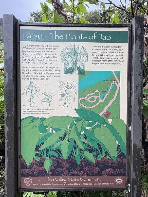
Along this trail you will see plants brought to Hawai'i by the early Polynesians. Kalo (taro) was the staple crop and fields of kalo once covered the floor of Iao Valley. The wetland variety is cultivated on level earthen terraces known as lo'i.
Water is diverted from the stream to flood the lo'i by 'auwai (ditches). Along the edges of the kalo fields were other crops such as kò (sugar cane), ti, olona, wauke, and mai'a (banana).
Since the arrival of the Western explorers in the late 1700s, new plants continue to be introduced to Hawai'i from all over the world. These exotics have invaded and displaced many of the native and Polynesian-introduced plants.
This garden area was initially constructed in 1964.
See if you can find the island of Maui.
Garden has been restored by volunteers
Topics. This historical marker is listed in these topic lists: Agriculture • Environment • Indigenous Peoples and Communities • Settlements & Settlers. A significant historical year for this entry is 1964.
Location. 20° 52.839′ N, 156° 32.772′ W. Marker is in Wailuku, Hawaii, in Maui County. It is on Iao Needle Lookout
this page online

Regionally, this marker is in Lahaina and West Maui. Globally, it is in North America, Polynesia, the Pacific Ocean, North Pacific, the Pacific Rim, the Western Hemisphere, the Western World, and the Anglosphere.
Other nearby markers. At least 8 other markers are within walking distance of this marker: Nā Wai 'Ehā - The Four Waters of Maui (within shouting distance of this marker); Battle of Kepaniwai - Uniting the Islands (within shouting distance of this marker); Kūka'emoku - 'Īao Needle (within shouting distance of this marker); Ka 'Ikena o 'Īao - Sites of 'Īao (within shouting distance of this marker); Wahi Pana o Nā Ali'i (Sacred Place of the Chiefs) (within shouting distance of this marker); Ka Wai Ola O Kāne (The Living Waters of Kāne) (within shouting distance of this marker); Kūka‘emoku (about 300 feet away, measured in a direct line);
Photographed by Darren Jefferson Clay, December 7, 2025
2. La'au - The Plants of 'Iao Marker
Credits. This page was last revised on February 6, 2026. It was originally submitted on February 1, 2026, by Darren Jefferson Clay of Duluth, Georgia. This page has been viewed 60 times since then. Photos: 1, 2. submitted on February 4, 2026, by Darren Jefferson Clay of Duluth, Georgia. • Devry Becker Jones was the editor who published this page.
