
River Valley Terwillegar in Edmonton in Edmonton Metropolitan Region, Alberta — Canada’s Prairie Region (North America)
Amisk Wacîw Mêskanaw Trail - Beaver Hill Road Trail

Photographed by Caroline Record, February 20, 2026
1. Amisk Wacîw Mêskanaw Trail Marker

[English]
Amisk Wacîw Mêskanaw Trail - Beaver Hill Road Trail
Amisk Wacîw Mêskanaw is a 100-km pedestrian trail connecting six municipalities through the North Saskatchewan River Valley: Parkland County, Devon, Edmonton, Strathcona County, Fort Saskatchewan and Sturgeon County.
"The nêhiyawak (Cree) were able to travel all of North and South America like it was our living room. We had specific routes for each kind of journey. We were able to develop a mental map of these many intricate pathways that are all part of the longer story. We always returned to the Treaty Six area, our sanctuary, where life began for us in the balance of winter and summer. Each trip we made had a name for it. This trail was known as Amisk Wacîw Mêskanaw, named for the large beaver dam on the river. Amisk is the beaver himself: Wacîw, a large hill. Mêskanaw translates to a sacred road or pathway. It is a kind and compassionate trail."
—Elder Jerry Saddleback
The River Valley Alliance acknowledges that the lands on which these communities and trail reside are in Treaty Six Territory. We deeply respect and wish to honour the diverse Indigenous Peoples whose ancestors' footsteps have marked this territory for centuries, including the nêhiyawak (Cree), Denesuliné (Dene), Nahkawininiwak (Saultaux or Plains Ojibwe), Nakota Isga (Nakota Sioux), and Niitsitapi (Blackfoot) Peoples. We further acknowledge these lands as the Métis homeland and the home of one of the largest communities of Inuit south of the 60th parallel.
[French]
this page online
— Elder Jerry Saddleback
[Cree] [NOTE re "with dot over": certain symbols in the inscription (with dots over them) have no Unicode representation. KW)]
[ᐁ with dot over]ᐦᐃᔭᐘᐠ ᑮᐦ ᑲᐢᑭᐦᑖᐘᐠ [ᐁ with dot over]ᐦ ᐱᒧᐦᑖᑐᑕᐦᑭᐠ ᑲᐦᑮᔭᐤ ᐆᒪ [ᒣ with dot over]ᓂᐢᑎᐠ ᑖᐱᐢᑰᐨ ᑭᑭᐦᒋ
ᐱᐢᑭᐦᒋᑲᒼᑯᓈᐦᐠ
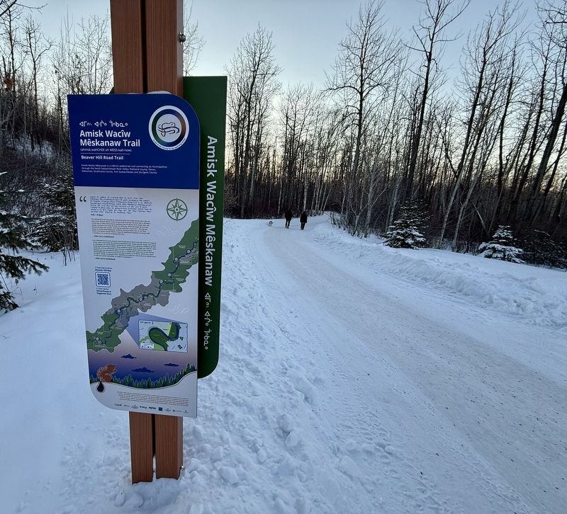
Photographed by Caroline Record, February 20, 2026
2. Amisk Wacîw Mêskanaw Trail Marker
ᑎᑕ ᒥᐢᑲᐚᐦᑖᔭᐦᐠ ᒥᒋ[ᒣ with dot over]᙮ᐦᑕᒫᐏᐣ ᑎᑖᑖᔨᓯᐦ ᒥᐦ[ᒉ with dot over]ᑑᐢᑳ[ᓀ with dot over]ᒧᐦᑕᔭᐦᐠ ᑭ[ᒣ with dot over]ᐢᑲᓈᒥᓇᐘᐦ ᑳ ᐃᓰ ᑭᑮᑲ[ᐍ with dot over]ᐦᐱᑏᐠ
ᑭᓄᓂᑰᐊᒋ ᒨᐏᓂᐦᐠ ᑖᐱᑕᐏ ᑮᐦ ᑮᐁᑐ[ᑌ with dot over]ᓇᐤ ᓂᑯᑤᑭᐠ ᑳᑭᐦ[ᑌ with dot over]ᐠ ᑮᑮᐑᐦ[ᑫ with dot over]ᐏᓂᓈᐦᐠ ᑭᑭᐦᒋᐦᑲᐏᓂᓅᐦᐠ ᐃᑕᐦ
ᐃᒫᑎᓱᐏᐣ ᑳᑮᐦ ᒫᒋᐸᔨᐠ ᑮᔮᓇᐤ ᐅᒋᐦ ᑳᐃᓯ ᑎᐸᐦ ᐚ ᐣᐸᔨ ᐱᐳᐣ [ᐁ with dot over]ᑿᐦ ᓃᐱᐤ [ᐁ with dot over]ᐦ ᐃᑕᐦᑎᐠ
ᐱᒧᐦᑕᐦᐅᐏᐣ ᑮᐦ ᐑᐦᐆᐏᐣ ᐄᐦᑖᓇᐤ ᐆᒪ ᐃᑎᐢᑲᓇ ᐚᐣ ᑮᐦ ᐃᓯ ᓂᐢᑕ[ᐍ with dot over]ᔨᐦᑖᑿᐣ ᐊᒥᐢᑿᒗᐤ [ᒣ with dot over]ᐢᑲᓇᐤ ᑰᐦ
ᐊᐢᐱᐦᑳ[ᑌ with dot over]ᐠ ᑳ ᒥᑳᐠ ᐊᒥᐢᑯ ᑭᐸᐦᐃᑲᐣ ᐊᒥᐢᐠ [ᐁ with dot over]ᐏᑯ ᐊᒥᐢᐠ ᐊᒌᐤ [ᐁ with dot over]ᐏᑯ ᒥᐢᐄᐢᐸᑎᓈᐤ ᒣᐢᑲᓇᐤ
ᐃ[ᑘ with dot over]ᒧᐦᒋᑳ[ᑌ with dot over] ᑭᒋᐦᑲᐤ ᐃᐢᑲᓇ[ᐍ with dot over]ᐏᐣ [ᐁ with dot over]ᐦ ᑭᓭᐚᑎᓲᒪᑲᐦᐠ ᒣᐢᑲᓇᐤ
ᐅᑭᒫᐤ ᑮᓯᑰᐃᔨᐣ
Topics. This historical marker is listed in these topic lists: Anthropology & Archaeology • Indigenous Peoples and Communities • Religion & Religious Structures • Roads & Vehicles.
Location. 53° 28.795′ N, 113° 35.976′ W. Marker is in Edmonton, Alberta, in Edmonton Metropolitan Region. It is in River Valley Terwillegar. It can be reached from Rooney Crescent Northwest west of Romaniuk Place Northwest, on the right when traveling west. Touch for map. Marker is at or near this postal address: 489 Rooney Crescent NW, Edmonton AB T6R 1E1, Canada. Touch for directions.

Regionally, this marker is in the Prairies. Globally, it is in North America, the Western Hemisphere, the Western World, and the Anglosphere. Historically, it finds itself in what was once a British colony and also Rupert’s Land.
Other nearby markers. At least 8 other markers are within 11 kilometers of this marker, measured as the crow flies: Strathcona Public Library (approx. 8.1 kilometers away); Fire Hall No. 6 (approx. 8.1 kilometers away); Strathcona Fire Hall Number 1 (approx. 8.1 kilometers away); The High Level Bridge (approx. 8.4 kilometers away); John Rowand (approx. 8.4 kilometers away); Creation of the Province of Alberta / Création de la province d'Alberta (approx. 8.7 kilometers away); Low Level Bridge (approx. 9.9 kilometers away); St. Luke's Anglican Church (approx. 11.1 kilometers away). Touch for a list and map of all markers in Edmonton.
Also see . . .
1. First Nation naming of the trail. (Submitted on February 27, 2026, by Caroline Record of Montréal, Québec.)
2. Economic impact of trail. (Submitted on February 27, 2026, by Caroline Record of Montréal, Québec.)
Credits. This page was last revised on July 30, 2026. It was originally submitted on February 27, 2026, by Caroline Record of Montréal, Québec. This page has been viewed 40 times since then. Photos: 1, 2. submitted on February 27, 2026, by Caroline Record of Montréal, Québec. • Devry Becker Jones was the editor who published this page.
