Near Lasauses in Conejos County, Colorado — The American Mountains (Southwest)
Río Grande del Norte — Big River of the North
| — | Los Caminos Antiguos Scenic & Historic Byway | — |

Photographed by Cosmos Mariner, July 12, 2025
1. Río Grande del Norte — Big River of the North Marker
“Swift, deep and wide ran the Río Grande through the San Luis Valley. Untapped by irrigation, crossing the Río Grande was a death defying experience for anyone who attempted it. The 1694 de Vargas entrada is the first record of a Spaniard successfully fording the ‘Big River’ at this location.” [Actually several miles south of this spot.]
“To feed the starving residents of Santa Fe, Don Diego de Vargas raided the village of Taos to steal corn from the Pueblos. De Vargas feared that the Pueblo Indians would retaliate, so he rode north into the unexplored territory of the San Luis Valley.”
“With 150 men and 300 fully packed mules and horses, he road fast and hard to find a successful crossing on the Río Grande, just south of where you are standing.” “...years after the de Vargas fording... the territorial legislature provided for a small ferry across the Río Grande to serve the settlers of the San Luis Valley.”
“Archeological evidence of the ferry's existence remains today.”
La Vereda; A Trail Through Time
Ruth Marie Colville
[photo captions]
• Don Diego de Vargas
• Before the Rio Grande was tapped by irrigation in 1873, it
this page online
• Soon after de Vargas crossed the Rio Grande, his men scattered 500 buffalo that a group of Utes were preparing to hunt. The Utes and de Vargas spent the morning of July 12 battling until a truce was made and the two sides worked together, hunting for food.
Erected by Colorado Scenic and Historic Byways Commission, Colorado Historical Society, Colorado Department of Transportation, and The Nature Conservancy.
Topics. This historical marker is listed in these topic lists: Exploration • Hispanic Americans • Indigenous Peoples and Communities • Waterways & Vessels. A significant historical date for this entry is July 12, 1694.
Location. 37° 10.842′ N, 105° 43.89′ W. Marker is near Lasauses, Colorado, in Conejos County. It is on State Highway 142 at milepost 14.2, 14.2 miles east of U.S. 285, on the right when traveling east. The marker is in the Rio Grande Natural Area interpretive wayside overlooking the west bank of the Rio Grande River. Touch for map. Marker is in this post office area: Sanford CO 81151, United States of America. Touch for directions.

Regionally,
Photographed by Cosmos Mariner, July 12, 2025
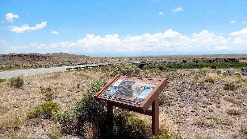
2. Río Grande del Norte — Big River of the North Marker
Looking northeast from the Rio Grande Natural Area wayside. The Colorado Highway 142 bridge over the Rio Grande River is in the left background.
Other nearby markers. At least 4 other markers are within 12 miles of this marker, measured as the crow flies: A Defining Moment in History (a few steps from this marker); Why a Natural Area? (a few steps from this marker); Pike's Stockade (approx. 9 miles away); Morman Pioneers (approx. 11.2 miles away).
Related markers. Click here for a list of markers that are related to this marker.
Also see . . .
1. New Mexico's Rio not-so Grande (Taos News).
(by J.R. Logan) Excerpt: There's a historical marker on a lonely stretch of Colorado State Highway 142, just north of the New Mexico border, marking the spot where Spanish conquistador Don Diego de Vargas crossed the Río Grande in the summer of 1694. These days, you could probably wade comfortably across the tranquil waters at that spot if you(Submitted on March 5, 2026, by Cosmos Mariner of Cape Canaveral, Florida.)didn't mind getting your shoes muddy.Photographed by Cosmos Mariner, July 12, 20253. Rio Grande Natural Area SignTurn here from Colorado Highway 142 to access the wayside and marker.
The reasons for this slimming are extremely complicated. Settlement in Colorado's San Luis Valley and the development of irrigation there more than a century ago drastically altered spring and summer flows, allowing agriculture in what was otherwise a high desert to grow into an enormous industry. Today, the river makes life possible for nearly everyone who lives in the valley.

2. Diego de Vargas (Wikipedia).
Excerpt: Diego de Vargas Zapata y Luján Ponce de León y Contreras (1643–1704), commonly known as Don Diego de Vargas, was a Spanish Governor of the New Spain territory of Santa Fe de Nuevo México (currently covering the modern US states of New Mexico and Arizona). He is known for leading the reconquest of the territory in 1692 following the Pueblo Revolt of 1680.(Submitted on March 6, 2026, by Cosmos Mariner of Cape Canaveral, Florida.)
In July 1692, de Vargas and a small contingent of soldiers returned to Santa Fe [from within present-day Colorado]. They surrounded the city and called on the Pueblo people to surrender, promising clemency if they would swear allegiance to theKing of Spain (at the time, Charles II of Spain) and return to the Christian faith. After meeting with de Vargas, the Pueblo leaders agreed to surrender, and on 12 September 1692 de Vargas proclaimed a formal act of repossession.Photographed by Cosmos Mariner, July 12, 20254. Colorado Highway 142 Bridge over the Rio Grande River at the Rio Grande Natural Area WaysideThe Rio Grande River headwaters are on the Continental Divide, over 100 miles northwest of here, high in the Colorado Rocky Mountains east of Silverton, Colorado. From here the Rio Grande flows more than 400 miles generally south through Colorado and New Mexico to El Paso, Texas. From El Paso the Rio Grande flows generally southwest to Brownsville, Texas, defining more than 1,000 miles of the U.S.A./Mexico international border. The total length of the Rio Grande River, including all the twists and turns from the Continental Divide to the Gulf of Mexico, is about 1,900 miles.

Credits. This page was last revised on March 6, 2026. It was originally submitted on March 2, 2026, by Cosmos Mariner of Cape Canaveral, Florida. This page has been viewed 56 times since then. Photos: 1, 2, 3, 4. submitted on March 5, 2026, by Cosmos Mariner of Cape Canaveral, Florida.
