Near Lasauses in Conejos County, Colorado — The American Mountains (Southwest)
Why a Natural Area?
Photographed by Cosmos Mariner, July 12, 2025
1. Why a Natural Area? Marker
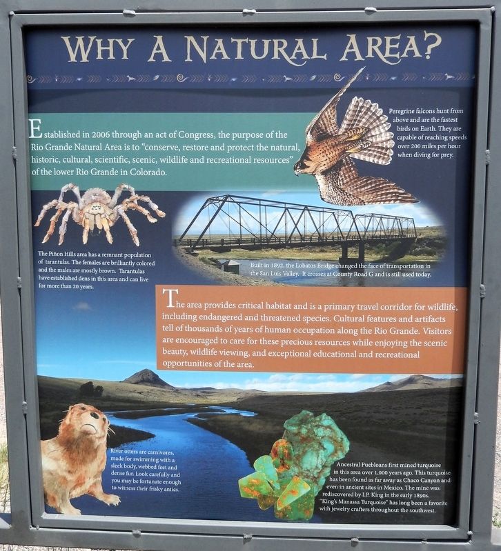
Established in 2006 through an act of Congress, the purpose of the Rio Grande Natural Area is to “conserve, restore and protect the natural, historic, cultural, scientific, scenic, wildlife and recreational resources” of the lower Rio Grande in Colorado.
Peregrine falcons hunt from above and are the fastest birds on Earth. They are capable of reaching speeds over 200 miles per hour when diving for prey.
The Piñon Hills area has a remnant population of tarantulas. The females are brilliantly colored, and the males are mostly brown. Tarantulas have established dens in this area and can live for more than 20 years.
Built in 1892, the Lobatos Bridge changed the face of transportation in the San Luis Valley. It crosses at County Road G and is still used today.
The area provides critical habitat and is a primary travel corridor for wildlife, including endangered and threatened species. Cultural features and artifacts tell of thousands of years of human occupation along the Rio Grande. Visitors are encouraged to care for these precious resources while enjoying the scenic beauty, wildlife viewing, and exceptional educational and
this page online
River otters are carnivores, made for swimming with a sleek body, webbed feet and dense fur. Look carefully and you may be fortunate enough to witness their frisky antics.
Ancestral Puebloans first mined turquoise in this area over 1,000 years ago. This turquoise has been found as far away as Chaco Canyon and even in ancient sites in Mexico. The mine was rediscovered by I.P. King in the early 1890s. “King's Manassa Turquoise” has long been a favorite with jewelry crafters throughout the southwest.
Erected by Colorado Scenic and Historic Byways Commission, Colorado Historical Society, Colorado Department of Transportation, and The Nature Conservancy.
Topics. This historical marker is listed in these topic lists: Animals • Anthropology & Archaeology • Indigenous Peoples and Communities • Parks & Recreational Areas. A significant historical year for this entry is 2006.
Location. 37° 10.832′ N, 105° 43.887′ W. Marker is near Lasauses, Colorado, in Conejos County. It is on State Highway 142 at milepost 14.2, 14.2 miles east of U.S. 285, on the right when traveling east. The marker

Photographed by Cosmos Mariner, July 12, 2025
2. Rio Grande Natural Area Interpretive Kiosk
Looking north; Colorado Highway 142 crosses in the background. This marker is the leftmost of two interpretive panels on the south side of the Rio Grande Natural Area kiosk.

Regionally, this marker is in the San Juan Mountains and in the San Luis Valley. It is also in the American Mountain West. Globally, it is in North America, the Rocky Mountains, the Western Hemisphere, the Western World, and the Anglosphere. Historically, it finds itself in what was once New Spain and also the Republic of Texas.
Other nearby markers. At least 4 other markers are within 12 miles of this marker, measured as the crow flies: A Defining Moment in History (here, next to this marker); Río Grande del Norte — Big River of the North (a few steps from this marker); Pike's Stockade (approx. 9 miles away); Morman Pioneers (approx. 11.2 miles away).
Also see . . .
1. Rio Grande Natural Area (Adams State University).
Excerpt: The Rio Grande Natural Area (RGNA) encompasses ¼ mile on both sides of the Rio Grande river corridor in Colorado, for about 32 miles from the south end of the Alamosa National Wildlife Refuge south to the boundary with New Mexico.(Submitted on March 6, 2026, by Cosmos Mariner of Cape Canaveral, Florida.)
2. King's Manassa Turquoise Mine.
Excerpt: The King's Manassa turquoise mine, or more accurately the "King Turquoise Mine", is located near Manassa, Colorado. It is one of the many turquoise deposits which was actively mined by Native Americans for centuries. I.P. King rediscovered the mine in 1890, and the King family has operated it ever since. It was originally called the Lick Skillet Mine. The Manassa turquoise mine produces an incredibly wide range of colors and qualities, from deep emerald greens to deep sky-blue.(Submitted on March 6, 2026, by Cosmos Mariner of Cape Canaveral, Florida.)
Credits. This page was last revised on March 6, 2026. It was originally submitted on March 2, 2026, by Cosmos Mariner of Cape Canaveral, Florida. This page has been viewed 42 times since then. Photos: 1, 2. submitted on March 6, 2026, by Cosmos Mariner of Cape Canaveral, Florida.
