
St. Catharines in Niagara Region, Ontario — Central Canada (North America)
Welcome To Malcolmson Eco-Park
Photographed by Kevin Westell, March 4, 2026
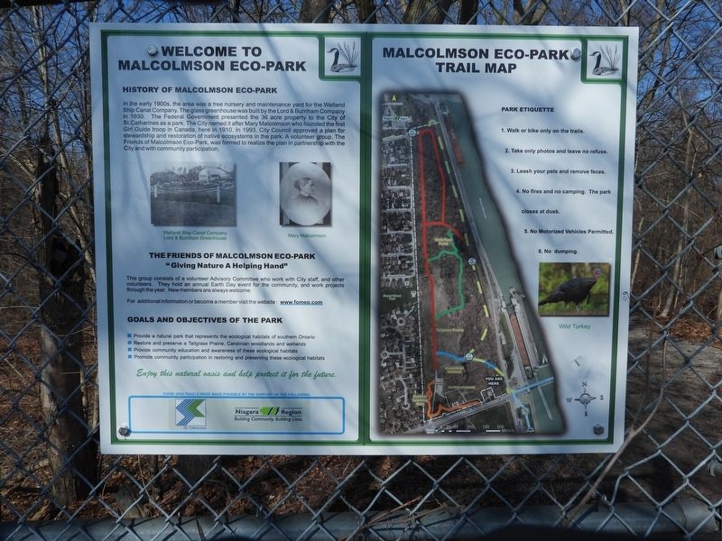
1. Welcome To Malcolmson Eco-Park Marker
In the early 1900s, the area was a tree nursery and maintenance yard for the Welland Ship Canal Company. The glass greenhouse was built by the Lord & Burnham Company in 1930. The Federal Government presented the 36 acre property to the City of St Catharines as a park. The City named it after Mary Malcolmson who founded the first Girl Guide troop in Canada, here in 1910. In 1993, City Council approved a plan for stewardship and restoration of native ecosystems in the park. A volunteer group, The Friends of Malcolmson Eco-Park, was formed to realize the plan in partnership with the City and with community participation.
The Friends of Malcolmson Eco-Park
"Giving Nature A Helping Hand"
This group consists of a volunteer Advisory Committee who work with City staff, and other volunteers. They hold an annual Earth Day event for the community, and work projects through the year. New members are always welcome.
For additional information or become a member visit the website: www.fomep.com
Goals and Objectives of the Park
- provide a natural park that represents
this page online
- Restore and preserve a tallgrass prairie, Carolinian woodland and wetlands
- Provide community education and awareness of these ecological habitats
- Promote community participation in restoring and preserving these ecological habitats
Enjoy this natural oasis and help protect it for the future.
Malcolmson Eco-Park Trail Map
Park Etiquette
1. Walk or bike only on the trails.
2. Take only photos and leave no refuse.
3. Leash your pets and remove feces.
4. No fires and no camping. The park closes at dusk.
5. No motorized vehicles permitted.
6. No dumping.
[ Captions for photos, left to right:
Welland Ship Canal Company Lord & Burnham Greenhouse
Mary Malcolmson
[A map of the park]
Wild Turkey ]
Erected by Friends of Malcolmson Eco-Park.
Topics and series. This historical marker is listed in these topic lists: Environment • Fraternal or Sororal Organizations • Parks & Recreational Areas • Waterways & Vessels. In addition, it is included in the The Welland Canals series list. A significant historical year for this entry is 1930.
Location. 43° 12.986′ N,
Photographed by Kevin Westell, March 3, 2026
2. Welcome To Malcolmson Eco-Park - Marker in context
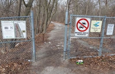
Photo faces north-west. Inside the park's fence, this trail bends left. It follows an old rail bed, which is one arm of an old wye, which permitted engines (using the main line of the Welland Ship Canal Construction Railway) to turn around.

Regionally, this marker is on Ontario’s Golden Horseshoe and in Niagara Canada. It is also in Central Canada. Globally, it is in North America, on the Great Lakes, in the Western Hemisphere, in the Western World, and in the Anglosphere. Historically, it finds itself in what was once a British colony, the Viceroyalty of New France, the Haudenosaunee (Iroquois) Confederacy, and Rupert’s Land.
Other nearby markers. At least 8 other markers are within walking distance of this marker: Welcome to Malcolmson Eco-Park (about 210 meters away, measured in a direct line); Port Weller Dry Docks (approx. 0.3 kilometers away); Charles A. Ansell Park (approx. 0.3 kilometers away); The Battle of Vimy Ridge/The History of Vimy Oak Trees
Photographed by Kevin Westell, March 4, 2026
3. Welcome To Malcolmson Eco-Park - Marker in context
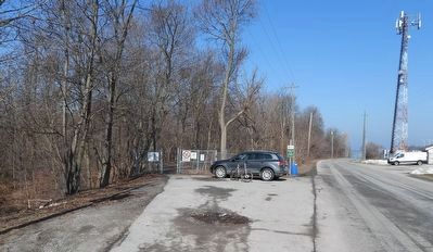
Photo faces north and north-west from the road. This small parking lot for park users can take 5 or so cars. The marker (centre left) is at a park entrance, on a raised railbed. Welland Canals Parkway (right) runs out of sight as it drops down to the level of the canal. Lock 1 is out of frame right.
More about this marker. This is one of five similar markers around the park.
Regarding Welcome To Malcolmson Eco-Park. 1. Malcolmson Park's location and surroundings makes it a good place to see birds. Besides the year-round residents, migrating birds travel along the Niagara isthmus; wintering water birds often loiter on the Welland Canal, north of Lock 1, where the water typically does not freeze over.
2. Some history:
- around 1910: Port Weller was a planned community, designed in parallel with the planning for the Welland Ship Canal (aka the Fourth Welland Canal, which is the current working canal). This strip of land (upon which Malcolmson Park now sits) was originally set aside as canal land.
- During canal construction (1913-1931), it was a supply depot. It had a wye for engines to turn around (on the map, the yellow dashed lines). The Welland Ship Canal Construction Railway ran north-south along the east side of this park (the straight part of the yellow dashed line); and along the west side of the canal from here down past the current Glendale Ave to the current flight locks. On the map, the red line that runs up the west side of the park was a road.
- By the end of the canal construction phase, the adjoining land had been all torn up. Briefly in the early 1930s, the canal project had a nursery sub-project, to raise trees and flowers to plant on these lands. (This was the time of the tree nursery and the greenhouse.)
- In the 1970s, the federal government (which owns the canal lands) gifted this land to the City of St. Catharines, and it became Malcolmson Park.
Also see . . . Friends of Malcolmson Eco-Park (web site). (Submitted on March 4, 2026, by Kevin Westell of St. Catharines, Ontario.)
Credits. This page was last revised on March 4, 2026. It was originally submitted on March 4, 2026, by Kevin Westell of St. Catharines, Ontario. This page has been viewed 33 times since then. Photos: 1, 2, 3. submitted on March 4, 2026, by Kevin Westell of St. Catharines, Ontario.
