La Villita in San Antonio in Bexar County, Texas — The American South (West South Central)
Mayor Maury Maverick Plaza
Photographed by Dave W, March 8, 2026
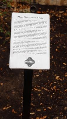
1. Mayor Maury Maverick Plaza Marker
Archaeology investigations have revealed tangible evidence of the long history of human settlement in Maverick Plaza. The oldest materials recovered, including chipped stone tools and ceramic sherds, are associated with Native Americans living in the area prior to the arrival of Europeans. Historical records suggest Spanish settlers moved into the Maverick Plaza area early in the 118th century.
In 1812, the Spanish government granted the land to Clemente Delgado (1760-1833), a Canary Islander who served as alcalde of San Antonio from 1810 to 1811. During the period of Mexican Independence and the Mexican Republic (ca. 1821-1836), Clemente divided the land among his family members who built houses, a lumberyard, and a stable. Plaster floors and artifacts related to these early homes were found during archaeological work.
Clemente Delgado's heirs began to sell the land in the 1850s and by 1873 the Delgado family houses were replaced by limestone houses typical of the mid-19th century in San Antonio. Many new families moved into the area, and commercial development of the site began in the late 19th century. Artifacts and building foundations from these later periods were also discovered.
Maverick Plaza's significant archaeological deposits and the site's built environment fall within the La Villita National Register of Historic Places District and La Villita Local Historic District.
Erected by City of San Antonio.
Topics. This historical marker is listed in these topic lists: Anthropology & Archaeology • Hispanic Americans • Indigenous Peoples and Communities • Settlements & Settlers. A significant historical year for this entry is 1812.
Location. 29° 25.279′ N, 98° 29.337′ W. Marker is in San Antonio, Texas, in Bexar County. It is in La Villita. It is on King Philip north of East Nueva
this page online

Regionally, this marker is in South Texas. It is also in the American South. Globally, it is in North America, a Gulf of Mexico state, the Western Hemisphere, the Western World, and the Anglosphere. Historically, it finds itself in what was once New Spain, the Republic of Texas, and one of the Confederate States of America.
Other nearby markers. At least 8 other markers are within walking distance of this marker: Esquida-Downs-Dietrich House (a few steps from this marker); Simon Bolivar (a few steps from this marker); 101 King Philip V Street (a few steps from this marker); John W. Smith (within shouting distance of this marker); St. Philip's College (within shouting distance of this marker); Cirilus Gissi House (within shouting distance of this marker); Kitchen (within shouting distance of this marker); Herrera House (within shouting distance of this marker). Touch for a list and map of all markers in San Antonio.
Also see . . . TSHA site for Mayor Maury Maverik with information and pictures.
Photographed by Dave W, March 8, 2026
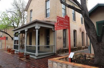
2. Mayor Maury Maverick Plaza Marker
Maury Maverick, congressman and mayor, son of Albert and Jane Lewis (Maury) Maverick and grandson of Samuel Augustus Maverick, was born in San Antonio, Texas, on October 23, 1895. He was educated in the public schools of San Antonio, Virginia Military Institute, the University of Texas in Austin, and the University of Texas School of Law.(Submitted on March 10, 2026, by Dave W of Co, Colorado.)
Credits. This page was last revised on March 12, 2026. It was originally submitted on March 10, 2026, by Dave W of Co, Colorado. This page has been viewed 13 times since then. Photos: 1, 2. submitted on March 10, 2026, by Dave W of Co, Colorado. • Devry Becker Jones was the editor who published this page.
