
Yorktown in York County, Virginia — The American South (Mid-Atlantic)
The Large Kiln
Historic Yorktown
| — | Colonial National Historical Park | — |

Photographed by Evan Dwyer, April 11, 2026
1. The Large Kiln Marker
The kiln's remains consist of the firebox, flue and arches, and a stoking pit where wood fuel was added and ashes were removed. In the above ground chamber, which had a capacity of approximately 310 cubic feet, wares were carefully stacked, maximizing the number of vessels fired, while ensuring the even distribution of heat.
A continuous sheet of green glaze from one to two inches thick covers the interior of the kiln - evidence that salt-glazed pottery was fired in the kiln, although earthenware may also have been fired here at a lower temperature.
Illustration Captions:
The kiln's original size may have been over ten feet tall.
The firing process could take several days. A small fire in the firebox preheated the kiln and, thereafter, the temperature was raised in an even and controlled manner by regulating the wood fuel and ventilation. After firing, the kiln was cooled before unloading.
Erected by National
this page online
Topics. This historical marker is listed in these topic lists: Anthropology & Archaeology • Colonial Era • Industry & Commerce.
Location. 37° 14.011′ N, 76° 30.508′ W. Marker is in Yorktown, Virginia, in York County. It is on Read Street 0.1 miles Main Street, on the right when traveling north. Marker is on the front of the National Park Service's archaeological site enclosure. Touch for map. Marker is at or near this postal address: 221 Read Street, Yorktown VA 23690, United States of America. Touch for directions.

Regionally, this marker is on Virginia’s Peninsula, in Coastal Virginia, and in the Hampton Roads Metropolitan Area. It is also in the American South, specifically in the Upper South, in the Tidewater, and on the Eastern Seaboard. Globally, it is in the North Atlantic Region, North America, the Western Hemisphere, the Western World, and the Anglosphere. Historically, it finds itself in what was once the territory of the Mississippian Culture, one of the original Thirteen Colonies, one of the Confederate

Photographed by Evan Dwyer, April 11, 2026
2. William Rogers' Pottery Enclosure
The marker is on the front of this archaeological site enclosure, next to (and here, obscured by) the door at left.
Other nearby markers. At least 8 other markers are within walking distance of this marker: The Work Shop and Laborers (here, next to this marker); Revealing the Past (here, next to this marker); The Waster Pit (a few steps from this marker); The Poor Potter of Yorktown (a few steps from this marker); The Poor Potter of Yorktown (Cont.) (a few steps from this marker); a different marker also named The Poor Potter of Yorktown (a few steps from this marker); Ballard House, circa 1709 (within shouting distance of this marker); Smith House, circa 1750 (about 300 feet away, measured in a direct line). Touch for a list and map of all markers in Yorktown.
Photographed by Evan Dwyer, April 11, 2026
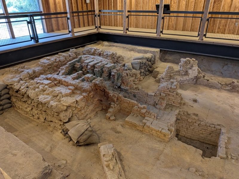
3. The Large Kiln
Housed within the National Park Service's archaeological enclosure. The interior is open seasonally, but is viewable from the marker through a large window with a knob to control the interior lights during the offseason.

Photographed by Evan Dwyer, April 11, 2026
4. The Large Kiln
This is the closest a visitor can get to the kiln. This view of the ruin is the opposite of the orientation of the drawing on the marker.

Photographed by Evan Dwyer, April 11, 2026
5. Kiln Model
Inside the enclosure, depicting the kiln conjecturally pre-ruin.
Credits. This page was last revised on April 21, 2026. It was originally submitted on April 18, 2026, by Evan Dwyer of Richmond, Virginia. This page has been viewed 14 times since then. Photos: 1, 2, 3, 4, 5. submitted on April 18, 2026, by Evan Dwyer of Richmond, Virginia. • Andrew Ruppenstein was the editor who published this page.
