Boerne in Kendall County, Texas — The American South (West South Central)
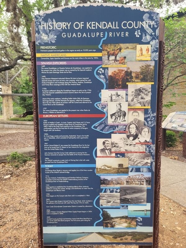
History of Kendall County
Guadalupe River
Photographed by James Hulse, April 26, 2026
1. History of Kendall County Marker
Prehistoric
Prehistoric people hunt and gather in the region as early as 10,000 years ago.
Native Americans
Comanches, Lipan Apaches and Kiowas are the main tribes in the area by 1700.
Spanish Explorers
1689
The name Guadalupe, or Nuestra Señora de Guadalupe, was applied to the present river when the stream was so named by the Spanish explorer Alonso de León and Domingo Terán de los Ríos.
1690
Fray Damián Massanet instructed Alonso de León to leave imported Spanish horses and cows at every river crossing, which started the wild herds of longhorn and mustangs along the Nueces, Medina, Guadalupe and Trinity River crossings of the Old San Antonio Road.
1720s
European settlement along the Guadalupe began as early as the 1720s when the Spanish established several missions above the site of present-day Victoria.
Most of the early explorers, including Father Isidro Félix de Espinosa, Domingo Ramón, and the Marqués de Aguayo, called the Guadalupe River the San Ybón above its junction with the Comal and referred to the Comal River as the Guadalupe.
1727
The name Guadalupe was applied to the present river when Pedro
this page online
European Settlers
1844
Battle of Walker’s Creek - In June, Captain Jack Hayes and 14 Texas Rangers battled and repelled a large band of Comanches led by Yellow Wolf at the Pinta Trail crossing on the Guadalupe. This confrontation was the first time that an entire company of Rangers fought with Colt revolvers.
1850s
Dr. Ernst Kapp creates and promotes Badenthal, Texas’s first health spa in Sisterdale, which consisted of hydropathy and a gymnastics regime.
1861
Brevet Colonel Robert E. Lee crosses the Guadalupe River for the last time as he travels from Ft. Mason to San Antonio for his resignation from the United States Army.
John Samson from the Currey Creek settlement is among the few German Unionists to escape from the Battle of the Nueces Massacre.
1880s
The SA&AP constructs a water tank at Waring that is fed with water pumped from the Guadalupe River.
Today
1900
Guadalupe River floods in January and topples two of the three wooden trusses of the SA&AP railroad bridge.
1914
The San Antonio, Fredericksburg and Northern Railway Company completes its line from the SA&AP Fredericksburg

Photographed by James Hulse, April 26, 2026
2. History of Kendall County Marker
The marker is located at the entrance to the Patrick Heath Public Library.
1933
State legislature established the Guadalupe-Blanco River Authority (GBRA) to oversee the control, storage, and distribution of water from the Guadalupe and Blanco rivers.
1958
Work begins on the Canyon Lake Dam and it is completed in 1964.
2002
The Canyon Lake Gorge is formed from this July flood, which resulted in the spillway’s first time use with water flowing over it for six weeks.
Cow Creek Groundwater Conservation District is created by referendum.
2006
GBRA Western Canyon Regional Water Supply Project begins in 2004 and is completed in 2006.
2009
Kendall County purchases and develops James Kiehl River Bend Park as part of the 2005 Park Bond program, the first county park along the Guadalupe River.
[Captions - Top to Bottom:]
Lipan tribe
Comanche warrior along river
Guadalupe River
Old Pinta Trail crossing
Explorers
Buffalo jump
Samson, 1st county sheriff
Northern Mexico cattleman, 1740
George Wilkins Kendall
Adeline de Valcourt Kendall
Kapp’s Badenthal, first health spa in Texas, c. 1860s
Jack Hays, Texas Ranger captain
Flood in 1900 at railroad bridge
Waring train depot and water tower
Railroad bridge over Guadalupe
Canyon Lake Dam, c. 1960s
Construction on dam, c. 1960s
Canyon Lake
Canyon Lake Gorge created after flood in 2002
Canyon Lake Dam
Erected by Guadalupe Blanco River Authority (GBRA).
Topics. This historical marker is listed in these topic lists: Hispanic Americans • Indigenous Peoples and Communities • Parks & Recreational Areas • Settlements & Settlers. A significant historical year for this entry is 1700.
Location. 29° 47.902′ N, 98° 43.887′ W. Marker is in Boerne, Texas, in Kendall County. It is at the intersection of North Main Street and Johns Road on North Main Street. Touch for map. Marker is at or near this postal address: 451 N Main St, Boerne TX 78006, United States of America. Touch for directions.

Regionally, this marker is in the Hill Country and in the San Antonio Metropolitan Area. Globally, it is in North America, a Gulf of Mexico state, the Western Hemisphere, the Western World, and the Anglosphere. Historically, it finds itself in what was once New Spain, the Republic of Texas, and one of the Confederate States of America.
Other nearby markers. At least 8 other markers are within walking distance of this marker: Local Groundwater (here, next to this marker); History of Boerne (here, next to this marker); Wells and Windmills (a few steps from this marker); Civic Campus History (within shouting distance of this marker); Native Plants (within shouting distance of this marker); Early Kendall County Farming and Ranching (within shouting distance of this marker); Did Indians Ever Live Here? (about 300 feet away, measured in a direct line); One-Time Hill Country Health Capital (about 400 feet away). Touch for a list and map of all markers in Boerne.
Credits. This page was last revised on April 28, 2026. It was originally submitted on April 27, 2026, by James Hulse of Medina, Texas. This page has been viewed 23 times since then. Photos: 1, 2. submitted on April 28, 2026, by James Hulse of Medina, Texas.
