
East Dover Hundred in Kent County, Delaware — The American Northeast (Mid-Atlantic)
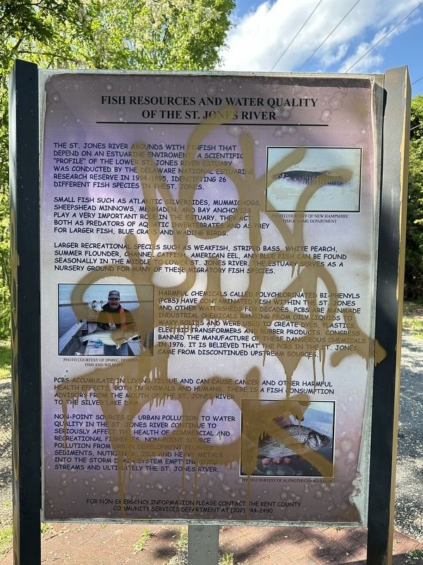
Fish Resources and Water Quality of the St. Jones River
Photographed by Pete Skillman, May 8, 2026
1. Fish Resources and Water Quality of the St. Jones River Marker
Small fish such as Atlantic silversides, mummichogs, sheepshead minnows, menhaden, and bay anchovies play a very important role in the estuary. They act both as predators of aquatic invertebrates and as prey for larger fish, blue crabs and wading birds.
Larger recreational species such as weakfish, striped bass, white pearch, summer flounder, channel catfish, American eel, and blue fish can be found seasonally in the middle to lower St. Jones River. The estuary serves as a nursery ground for many of these migratory fish species.
Harmful chemicals called polychlorinated bi-phenyls (PCBs) have contaminated fish within the St. Jones and other watersheds for decades. PCBs are manmade industrial chemicals ranging from oily liquids to waxy solids and were used to create dyes, plastics, electric transformers and rubber products. Congress banned
this page online
PCBs accumulate in living tissue and can cause cancer and other harmful health effects, both in animals and humans. There is a fish consumption advisory from the mouth of the St. Jones River to the Silver Lake Dam.
Non-point sources of urban pollution to water quality in the St. Jones River continue to seriously affect the health of commercial and recreational fisheries. Non-point source pollution from urban development flushes sediments, nutrients, oils and heavy metals into the storm drain system emptying into streams and ultimately the St. Jones River.
For non-emergency information please contact the Kent County Community Services Department at (302) 744-2490.
[Captions]:
Photo courtesy of New Hampshire Fish & Game Department
Photo courtesy of DNREC, Division of Fish and Wildlife
Photo courtesy of alongthecharles.com
Topics. This historical marker is listed in these topic lists: Animals • Environment • Parks & Recreational Areas • Waterways & Vessels. A significant historical year for this entry is 1994.
Location. 39° 8.274′ N,

Photographed by Pete Skillman, May 8, 2026
2. Fish Resources and Water Quality of the St. Jones River Marker - wide view

Regionally, this marker is in the American Mid-Atlantic, on the Delmarva Peninsula, and on the Eastern Seaboard. Globally, it is in the North Atlantic Region, North America, the Western Hemisphere, the Western World, and the Anglosphere. Historically, it finds itself in what was once New Netherland, one of the original Thirteen Colonies, and the Antebellum South.
Other nearby markers. At least 8 other markers are within 2 miles of this location, measured as the crow flies: St. Jones River Wild Life and Habitats (here, next to this marker); St. Jones River Wildlife and Habitats (approx. 0.6 miles away); Wolf Creek - A River Changes Course (approx. 0.6 miles away); September 11, 2001 Memorial (approx. 0.6 miles away); American Legion Veterans Memorial (approx. 0.7 miles away); Kent County Theatre Guild (approx. one mile away); Dover (approx. 1.3 miles away); Bell UH-1 Iroquois Helicopter (approx. 1.4 miles away). Touch for a list and map of all markers in Dover.
More about this marker. The marker has been damaged by graffiti. It is located along the St. Jones Greenway Trail.
Also see . . . NOAA - Delaware National Estuarine Research Reserve.
This reserve consists of two components: 1,087 acres of freshwater wetlands, ponds, and forest lands in Blackbird Creek, and 5,119 acres of salt marsh and open water habitats on the St. Jones River on Delaware Bay. The Blackbird Creek watershed is a predominantly rural area consisting of wetlands, forests, and agricultural lands. The St. Jones River watershed has significant development in upstream non-tidal area, where urbanized Dover dominates the middle and upper watershed. Downstream portions of the St. Jones River watershed are still primarily agricultural.(Submitted on May 9, 2026, by Pete Skillman of Townsend, Delaware.)
Credits. This page was last revised on May 15, 2026. It was originally submitted on May 8, 2026, by Pete Skillman of Townsend, Delaware. This page has been viewed 13 times since then. Photos: 1, 2. submitted on May 8, 2026, by Pete Skillman of Townsend, Delaware.
