District de Hull in Gatineau in Outaouais, Québec — Central Canada (French-Canadian)
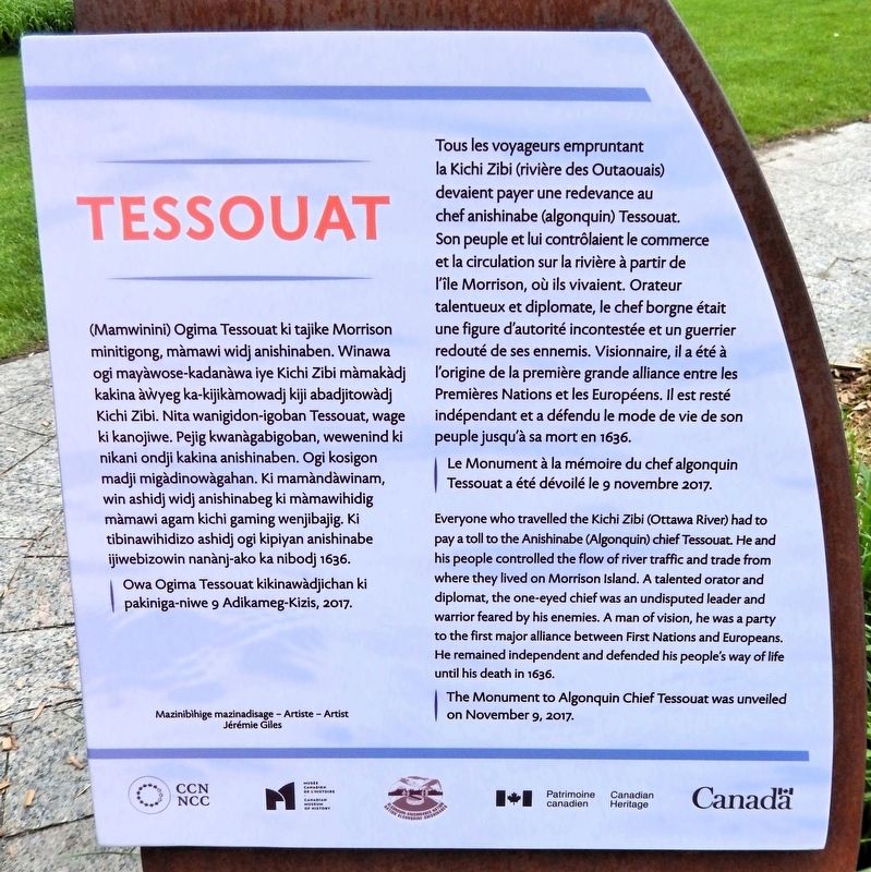
Tessouat
| — | Artiste Jérémie Giles Artist | — |
Photographed by Cosmos Mariner, May 28, 2024
1. Tessouat Marker

Le Monument à la mémoire du chef algonquin Tessouat a été dévoilé le 9 novembre 2017.
this page online
The Monument to Algonquin Chief Tessouat was unveiled on November 9, 2017.
Owa Ogima Tessouat kikinawàdjichan ki pakiniga-niwe 9 Adikameg-Kizis, 2017.
Erected 2017 by Musée canadien de l’histoire & Patrimoine canadien / Canadian Museum of History & Canadian Heritage.
Topics. This historical marker is listed in these topic lists: Colonial Era • Indigenous Peoples and Communities • Industry & Commerce • Waterways & Vessels.
Location. 45° 25.731′ N, 75° 42.454′ W.
Photographed by Cosmos Mariner, May 28, 2024
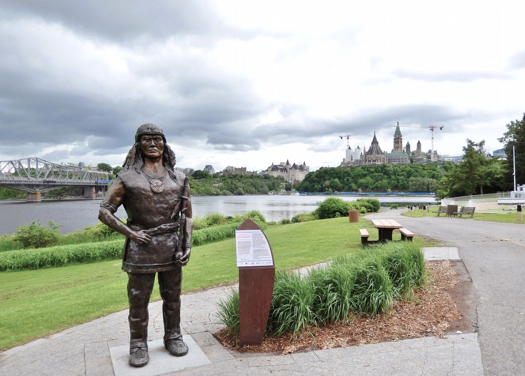
2. Tessouat Sculpture & Marker
Looking south along the Voyageurs Pathway. The Ottawa River and Parliament Hill are in the background.

Regionally, this marker is in the Ottawa Metropolitan Area and in the Outaouais & Eastern Townships. It is also in Central Canada. Globally, it is in North America, the Great North Woods, the Western Hemisphere, and the Western World. Historically, it finds itself in what was once a British colony, the Viceroyalty of New France, the Haudenosaunee (Iroquois) Confederacy, and Rupert’s Land.
Other nearby markers. At least 8 other markers are within walking distance of this marker: Le Parlement du Canada / Canada's Parliament (about 120 meters away, measured in a direct line); La Tour de Lessivage / The Digester Tower (about 210 meters away); École Normale St-Joseph (approx. 0.3 kilometers away); Deux cents ans d'essor / 200 Years in the Making (approx. 0.3 kilometers away); Mère Élisabeth Bruyère : une femme inspirante (approx. 0.4 kilometers away); Le Quartier-du-Musée : Des habitants qui ont marqué l'histoire de Hull (approx. 0.4 kilometers away); Le Quartier-du-Musée : Un lieu résidentiel, commercial et professionnel (approx. 0.4 kilometers away); Alexandra (Interprovincial) Bridge / Pont Alexandra (Interprovincial) (approx. 0.4 kilometers away in Ontario). Touch for a list and map of all markers in Gatineau.
Also see . . .
1. Tessouat (Wikipedia).
Excerpt : Tessouat was an Algonquin chief from the Kitchesipirini nation ("Kitche"=Great, "sipi"=river, "rini"=people: the people from the great river, the Ottawa River). His nation lived in an area extending from Lake of Two Mountains to modern-day Pembroke, Ontario. Tessouat lived in L'Isle-aux-Allumettes, in a neck of the Ottawa River. He was described by the French settlers as having a strong character. He was also blind in one eye (in French, borgne) and was dubbed "le Borgne de l'isle". His position was highly strategic, as the Ottawa River was the safest way to go from the St. Lawrence River to Hudson Bay and to Huronia, near Georgian Bay. Tessouat took advantage of his position to impose some sort of customs duties on the French fur traders navigating on the Ottawa River, as well as to impose some of his authority. For example, in 1633, he refused to let the Jesuits go to Huronia, fearing he would lose authority in the region.(Submitted on June 14, 2026, by Cosmos Mariner of Cape Canaveral, Florida.)
2. Tessouat (Dictionary of Canadian Biography).
(by Elsie McLeod Jury) Excerpt: Tessouat was a chief of considerable influence because of the strategic location of his tribe on Allumette Island, now Morrison Island, between Upper and Lower Allumette lakes. Rapids necessitating a portage surrounded this island and blocked the route of the Huron and other northern tribes to the St. Lawrence by way of the Ottawa River. It was Indian custom to recognize the rights of other tribes in matters of travel and trade, and not even the much stronger Hurons would pass the island without the consent of the inhabitants or without paying the required customs. Thus it was in the power of Tessouat virtually to control the flow of trade on the Ottawa River.(Submitted on June 14, 2026, by Cosmos Mariner of Cape Canaveral, Florida.)
Credits. This page was last revised on June 14, 2026. It was originally submitted on June 14, 2026, by Cosmos Mariner of Cape Canaveral, Florida. This page has been viewed 16 times since then. Photos: 1, 2. submitted on June 14, 2026, by Cosmos Mariner of Cape Canaveral, Florida.
