
Stevensville in Fort Erie in Niagara Region, Ontario — Central Canada (North America)
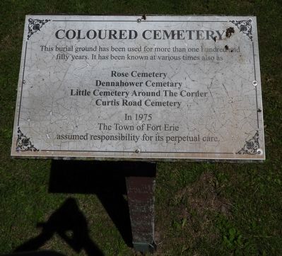
Coloured Cemetery
Photographed by Kevin Westell, June 23, 2026
1. Coloured Cemetery - Marker
Rose Cemetery
Dennahower Cemetary
Little Cemetery Around The Corner
Curtis Road Cemetery
In 1975 The Town of Fort Erie assumed responsibility for its perpetual care.
Erected 1991 by Town of Fort Erie.
Topics. This historical marker is listed in these topic lists: Abolition & Underground RR • African Americans • Cemeteries & Burial Sites • Immigration. A significant historical year for this entry is 1813.
Location. 42° 56.26′ N, 79° 0.216′ W. Marker is in Fort Erie, Ontario, in Niagara Region. It is in Stevensville. It is on Curtis Road 0 kilometers east of Ridgemount Road, on the right when traveling west. Touch for map. Marker is at or near this postal address: 2300 Curtis Rd, Fort Erie ON L0S 1S0, Canada. Touch for directions.

Regionally, this marker is on Ontario’s Golden Horseshoe and in Niagara Canada. It is also in Central Canada. Globally, it is in North America, on the Great Lakes, in the Western Hemisphere, in the Western World, and in the Anglosphere.
this page online
Other nearby markers. At least 8 other markers are within 5 kilometers of this marker, measured as the crow flies: Crossing of the River Brethren (approx. 3 kilometers away); The Welland Canal at the Niagara Frontier (approx. 3 kilometers away); Bert Miller (approx. 3 kilometers away); Marina (approx. 3 kilometers away); Niagara's Freedom Trail - Little Africa (approx. 3 kilometers away); Gonder's Flats (approx. 3.5 kilometers away); Stevensville War Memorial (approx. 4.2 kilometers away); For the Birds (approx. 4.3 kilometers away in the U.S.). Touch for a list and map of all markers in Fort Erie.
Regarding Coloured Cemetery. Burials here occurred from 1813 - 1912. The cemetery has a mix of black people and white people. In 1991, of the legible gravestones, 52 were for white people, and 8 for black people. But, this is not necessarily representative of the burials here: the earliest gravestones were of limestone, and are no longer readable.
Also see . . . Memo about this cemetery and its naming (August 2023, by Fort Erie Museum manager).
Photographed by Kevin Westell, June 23, 2026
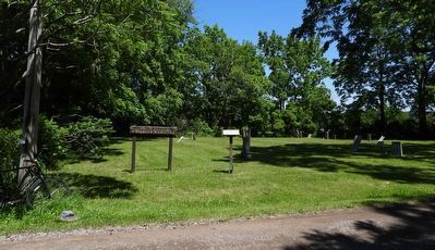
2. Coloured Cemetery
Photo faces north and north-east from Curtis Road. The marker (centre) is beside the road, at the south-west corner of the cemetery.
Credits. This page was last revised on June 25, 2026. It was originally submitted on June 25, 2026, by Kevin Westell of St. Catharines, Ontario. This page has been viewed 13 times since then. Photos: 1, 2. submitted on June 25, 2026, by Kevin Westell of St. Catharines, Ontario.
