
Bouckville in Madison County, New York — The American Northeast (Mid-Atlantic)
Chenango Canal Towpath
Photographed by Susan A. Dalaba, June 26, 2026
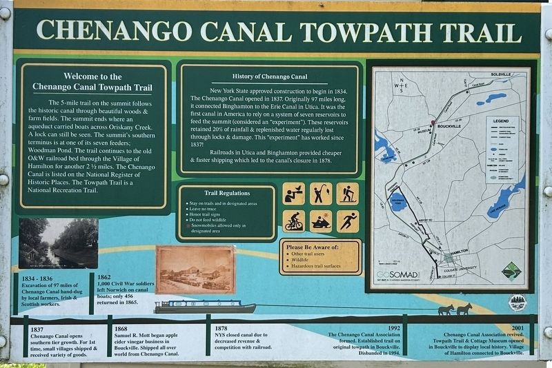
1. Chenango Canal Towpath Marker
Welcome to the Chenango Canal Towpath Trail
The 5-mile trail on the summit follows the historic canal through beautiful woods & farm fields. The summit ends where an aqueduct carried boats across Oriskany Creek. A lock can still be seen. The summit’s southern terminus is at one of the seven feeders; Woodman Pond. The trail continues to the old O & W railroad bed through the Village of Hamilton for another 2½ miles. The Chenango Canal is listed on The National Register of Historic Places. The Towpath Trail is a National Recreation Trail.
History of Chenango Canal
New York State approved construction to begin in 1834. The Chenango Canal opened in 1837. Originally 97 miles long it connected Binghamton to the Erie Canal in Utica. It was the first canal in America to rely on a system of seven reservoirs to feed the summit (considered an “experiment”). These reservoirs retained 20% of rainfall & replenished water regularly lost through locks & damage. This “experiment” has worked since 1837!
Railroads in Utica and Binghamton provided cheaper & faster shipping which led to the canal’s closure in 1878.
1834 - 1836
Excavation
this page online
1837
Chenango Canal opens southern tier growth. For 1st time, small villages shipped & received variety of goods.
1862
1,000 Civil War soldiers left Norwich on canal boats; only 456 returned in 1865.
1868
Samuel R. Mott began apple cider vinegar business in Bouckville. Shipped all over world from Chenango Canal.
1878
NYS closed canal due to decreased revenue & competition with railroad.
1992
The Chenango Canal Association formed. Established trail on original towpath in Bouckville. Disbanded in 1994.
2001
Chenango Canal Association revived. Towpath Trail & Cottage Museum opened in Bouckville to display local history. Village of Hamilton connected to Bouckville.
Topics. This historical marker is listed in these topic lists: Industry & Commerce • Parks & Recreational Areas • War, US Civil • Waterways & Vessels. A significant historical year for this entry is 1834.
Location. 42° 53.341′ N, 75° 33.112′ W. Marker is in Bouckville, New York, in Madison County. It is at the intersection of U.S. 20 and Canal Road, on the right

Photographed by Susan A. Dalaba, June 26, 2026
2. Chenango Canal Towpath Marker

Regionally, this marker is in Upstate New York, specifically in Central New York, and in the Syracuse Metropolitan Area. It is also in the American Northeast and in the Mid-Atlantic. Globally, it is in North America, the Western Hemisphere, the Western World, and the Anglosphere. Historically, it finds itself in what was once the Haudenosaunee (Iroquois) Confederacy, New Netherland, and one of the original Thirteen Colonies.
Other nearby markers. At least 8 other markers are within 4 miles of this marker, measured as the crow flies: Chenango Canal (within shouting distance of this marker); Welcome to the Chenango Canal Towpath Trail (about 400 feet away, measured in a direct line); First Hop Yard (approx. ¾ mile away); Col. Joshua Leland (approx. 1.2 miles away); Toll Gate No. 1 (approx. 2½ miles away); Home of Cyrus and Elizabeth Heminway Finney (approx. 3.6 miles away); Site of Farm (approx. 3.6 miles away); Madison Street Cemetery (approx. 3.8 miles

Photographed by Susan A. Dalaba, June 26, 2026
3. Chenango Canal Towpath Marker
Also see . . .
1. Chenango Canal Association. (Submitted on June 29, 2026.)
2. Chenango Canal. Wikipedia (Submitted on June 29, 2026.)
Credits. This page was last revised on June 29, 2026. It was originally submitted on June 27, 2026, by Susan A. Dalaba of Cortland, New York. This page has been viewed 10 times since then. Photos: 1, 2, 3. submitted on June 27, 2026, by Susan A. Dalaba of Cortland, New York. • Bernard Fisher was the editor who published this page.
