Williamstown in Berkshire County, Massachusetts — The American Northeast (New England)
Mohican Homelands
Stockbridge-Munsee Community
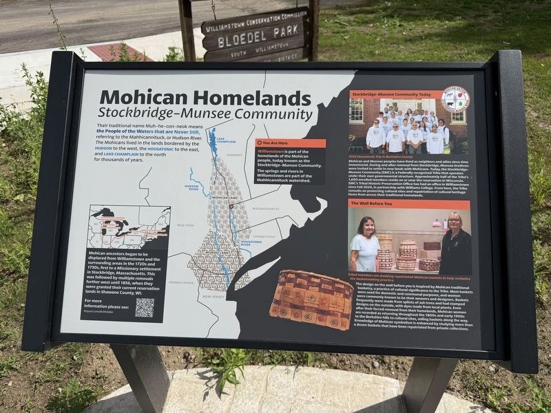
Their traditional name Muh-he-con-neok means the People of the Waters that are Never Still, referring to the Mahhicannituck, or Hudson River. The Mohicans lived in the lands bordered by the Hudson to the west, the Housatonic to the east, and Lake Champlain to the north for thousands of years.
〇 You Are Here
Williamstown is part of the homelands of the Mohican people, today known as the Stockbridge–Munsee Community.
The springs and rivers in Williamstown are part of the Mahhicannituck watershed.
Mohican ancestors began to be displaced from Williamstown and the surrounding areas in the 1720s and 1730s, first to a missionary settlement in Stockbridge, Massachusetts. This was followed by multiple removals further west until 1856, when they were granted their current reservation lands in Shawano County, WI.
Stockbridge–Munsee Community Today
2024 Homelands Trip in Berkshire County
Mohican and Munsee peoples have lived as neighbors and allies since time immemorial. During and after removal from Stockbridge, Munsee brethren were invited to settle in new lands with Mohicans. Today, the Stockbridge–Munsee
this page online
The Wall Before You
Tribal members are studying repatriated Mohican baskets to help revitalize the basketmaking practice.
The design on the wall before you is inspired by Mohican traditional basketry, a practice of cultural significance to the Tribe. Most baskets were used for domestic and communal purposes, and women were commonly known to be their weavers and designers. Baskets frequently were made from splints of ash trees and had stamped designs on the outside, with dyes made from local plants. Even after their forced removal from their homelands, Mohican women continued to return throughout the 1800s and early 1900s to the Berkshire hills to cultural
Topics. This historical marker is listed in these topic lists: Anthropology & Archaeology • Colonial Era • Indigenous Peoples and Communities • Settlements & Settlers. A significant historical year for this entry is 1856.
Location. 42° 39.626′ N, 73° 14.491′ W. Marker is in Williamstown, Massachusetts, in Berkshire County. It is at the intersection of New Ashford Road (Route 7) and Hancock Road (Massachusetts Route 43), on the right when traveling south on New Ashford Road. Touch for map. Marker is at or near this postal address: 4 New Ashford Rd, Williamstown MA 01267, United States of America. Touch for directions.

Regionally, this marker is in the Berkshires. It is also in the American Northeast and in New England. Globally, it is in North America, the Western Hemisphere, the Western World, and the Anglosphere. Historically, it finds itself in what was once one of the original Thirteen Colonies.
Other nearby markers. At least 8 other markers

Credits. This page was last revised on June 27, 2026. It was originally submitted on June 27, 2026, by Devry Becker Jones of Washington, District of Columbia. This page has been viewed 10 times since then. Photos: 1, 2, 3. submitted on June 27, 2026, by Devry Becker Jones of Washington, District of Columbia.
