Galveston in Galveston County, Texas — The American South (West South Central)
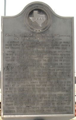
Near Campsites of Louis-Michel Aury and Francisco Xavier Mina
Inscription.
A bivouac in late 1816 and early 1817 for an oddly mixed group of soldiers from many nations joined in the common purpose of freeing Mexico from Spain. Under two spirited leaders-- Mina (1789-1817), an impetuous young Spanish general, and Aury (about 1788-1821), a French privateer and soldier of fortune--the forces drilled while waiting reinforcements and the best time to strike. For six years Mexico had been trying to wrest power from Spain but lacked military leadership and supplies. These items the two young adventurers hoped to furnish. Aury had already been chosen by Mexican rebel leaders as "Commissioner" of Galveston Island, from which he preyed on Spanish shipping. At the campsite, Mina's cargo was stored in the hulk of an abandoned ship and, under a torrid sun, he set up tents west of "Galvez Town." Aury, from his store of booty, supplied all with excellent rations. On April 7, 1817, Mina's invaders sailed, with eight ships and about 235 men, for Soto la Marina; Aury stayed at Galveston. At first victorious, Mina moved inland but was defeated at Venadito on October 27. Three years later, having gained from early rebel efforts such as these, Mexico won her freedom.
Erected 1968 by State Historical Survey Committee. (Marker Number 9925.)
Topics. This historical marker is listed in these topic lists: Colonial Era • Hispanic Americans • Wars, Non-US. A significant historical month for this entry is April 1789.
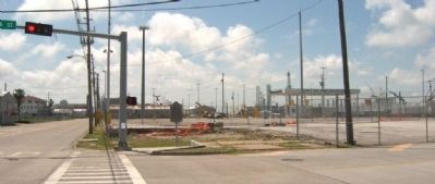
Location. 29° 18.655′ N, 94° 47.066′ W. Marker is in Galveston, Texas, in Galveston County. Marker is at the intersection of 14th Street and Harborside Drive, on the left when traveling north on 14th Street. Touch for map. Marker is in this post office area: Galveston TX 77550, United States of America. Touch for directions.
Other nearby markers. At least 8 other markers are within walking distance of this marker. Jean Lafitte (about 300 feet away, measured in a direct line); George Washington Grover House (approx. ¼ mile away); Dominican Sisters (approx. ¼ mile away); Galveston Immigration Stations (approx. ¼ mile away); Victor Gustafson Home (approx. 0.3 miles away); Davidson-Penland House (approx. 0.3 miles away); Landes-McDonough House (approx. 0.3 miles away); "Old Red" (approx. 0.3 miles away). Touch for a list and map of all markers in Galveston.
Also see . . . Francisco Xavier Mina. Biographical article in the Handbook of Texas online. (Submitted on May 9, 2010, by Gregory Walker of La Grange, Texas.)
Credits. This page was last revised on November 18, 2020. It was originally submitted on May 7, 2010, by Gregory Walker of La Grange, Texas. This page has been viewed 1,578 times since then and 27 times this year. Photos: 1, 2. submitted on May 7, 2010, by Gregory Walker of La Grange, Texas. • Bill Pfingsten was the editor who published this page.

