Sarah Ann in Logan County, West Virginia — The American South (Appalachia)
The Feud
Hatfield Cemetery
Photographed by Mark Parker, July 11, 2026
1. The Feud Marker
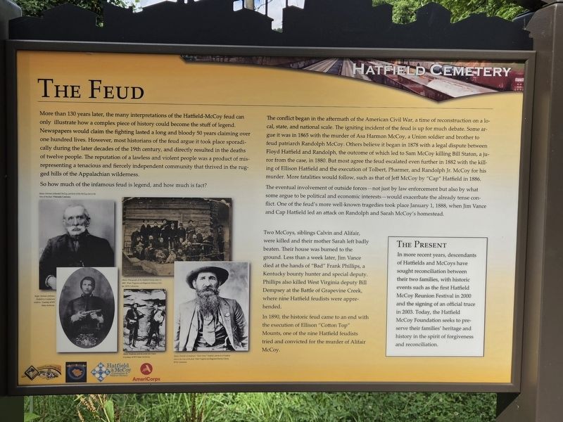
More than 130 years later, the many interpretations of the Hatfield-McCoy feud can only illustrate how a complex piece of history could become the stuff of legend. Newspapers would claim the fighting lasted a long and bloody 50 years claiming over one hundred lives. However, most historians of the feud argue it took place sporadically during the later decades of the 19th century, and directly resulted in the deaths of twelve people. The reputation of a lawless and violent people was a product of misrepresenting a tenacious and fiercely independent community that thrived in the rugged hills of the Appalachian wilderness.
So how much of the infamous feud is legend, and how much is fact?
The conflict began in the aftermath of the American Civil War, a time of reconstruction on a local, state, and national scale. The igniting incident of the feud is up for much debate. Some argue it was in 1865 with the murder of Asa Harmon McCoy, a Union soldier and brother to feud patriarch Randolph McCoy. Others believe it began in 1878 with a legal dispute between Floyd Hatfield and Randolph, the outcome of which led to Sam McCoy
this page online
The eventual involvement of outside forces — not just by law enforcement but also by what some argue to be political and economic interests — would exacerbate the already tense conflict. One of the feud's more well-known tragedies took place January 1, 1888, when Jim Vance and Cap Hatfield led an attack on Randolph and Sarah McCoy's homestead.
Two McCoys, siblings Calvin and Alifair, were killed and their mother Sarah left badly beaten. Their house was burned to the ground. Less than a week later, Jim Vance died at the hands of "Bad" Frank Phillips, a Kentucky bounty hunter and special deputy. Phillips also killed West Virginia deputy Bill Dempsey at the Battle of Grapevine Creek where nine Hatfield feudists were apprehended.
In 1890, the historic feud came to an end with the execution of Ellison "Cotton Top" Mounts, one of
Photographed by Mark Parker, July 11, 2026
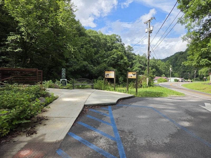
2. The Feud Marker (left) at the trailhead to Hatfield cemetery.
[Sidebar]
The Present
In more recent years, descendants of Hatfields and McCoys have sought reconciliation between their two families, with historic events such as the first Hatfield McCoy Reunion Festival in 2000 and the signing of an official truce in 2003. Today, the Hatfield McCoy Foundation seeks to preserve their families' heritage and history in the spirit of forgiveness and reconciliation.
[Captions]
Below: Portrait of Randall McCoy, patriarch of the McCoy clan at the time of the feud. Wikimedia Commons
Right: Portrait of Ellison Hatfield in Confederate uniform.
Courtesy of WV State Archives.
Above: Photograph of the Hatfield Family taken in 1887.
West Virginia & Regional History Center, WVU Libraries
Above: Anderson and his uncle Jim Vance
Courtesy of WV State Archives
Above: Portrait of Anderson"Devil Anse" Hatfield, patriarch of Hatfield clan at the time of the feud
West Virginia & Regional History Center, WVU Libraries.
Erected by National Coal Heritage Area, Logan County Commission, Hatfield & McCoy Convention & Visitors Bureau, AmeriCorp.
Topics. This historical marker is listed in these topic lists: Law Enforcement • Notable Events • War, US Civil. A significant historical date for this entry is January 1, 1888.
Location. 37° 42.152′ N, 81° 59.582′ W. Marker is in Sarah Ann, West Virginia, in Logan County. It is on Jerry West Highway (West Virginia Route 44) half a mile south of Philips Street, on the right when traveling south. The marker is located at the trailhead leading to Hatfield Cemetery. Touch for map. Marker is at or near this postal address: 12672 Jerry West Hwy, Sarah Ann WV 25644, United States of America. Touch for directions.

Regionally, this marker is in the Southern Coalfields. It is also in the American South, specifically in the Upper South, in Appalachia, and specifically in Southern Appalachia. Globally, it is in North America, the Western Hemisphere, the Western World, and the Anglosphere. Historically, it finds itself in what was once the territory of the Mississippian Culture.
Other nearby markers. At least 8 other markers are within walking distance of this marker: The Man: "Devil Anse" Hatfield (here, next to this marker); The Land (within shouting distance of this marker); The Family (about 600 feet away, measured in a direct line); The Resting Place (about 600 feet away); Devil Anse Hatfield's Homeplace (about 700 feet away); Hatfield Family Well (about 700 feet away); Hatfield Cemetery (about 700 feet away); Devil Anse Hatfield's Homeplace Bridge (about 700 feet away). Touch for a list and map of all markers in Sarah Ann.
Regarding The Feud. A trail from the "Hatfield Cemetery" marker north of this spot still exists, but a new trail has been completed here with a small parking area. Both trails are steep, but this one has a longer grade and paved with gravel. This trail is about 3/10 of a mile to reach the cemetery.
Credits. This page was last revised on July 23, 2026. It was originally submitted on July 22, 2026, by Mark Parker of Hickory, North Carolina. This page has been viewed 9 times since then. Photos: 1. submitted on July 22, 2026, by Mark Parker of Hickory, North Carolina. 2. submitted on July 23, 2026, by Mark Parker of Hickory, North Carolina. • Devry Becker Jones was the editor who published this page.
