Mount Waverley in Monash, Victoria, Australia — Oceania
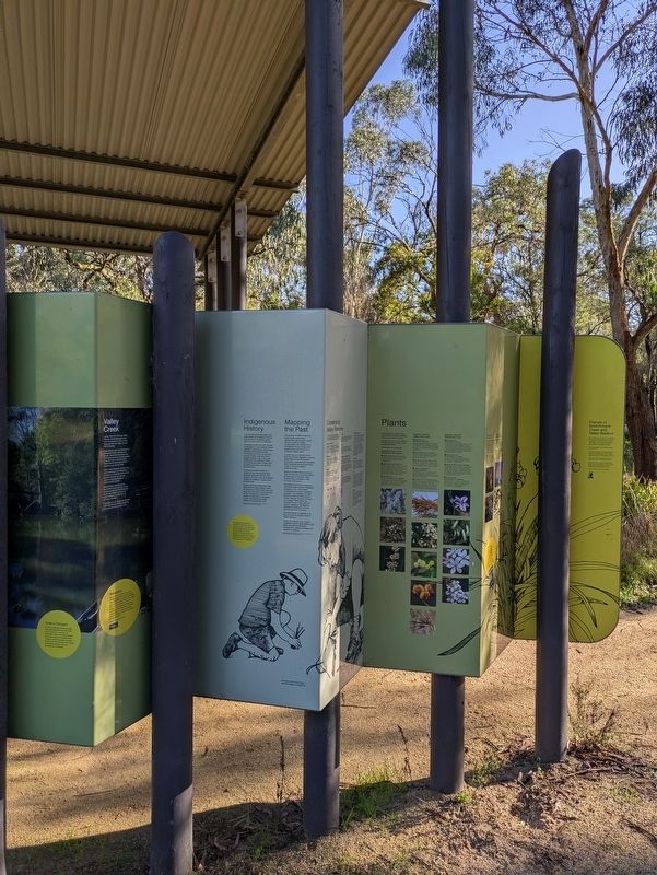
Indigenous History and Mapping the Past
Valley Conservation Reserve

Photographed by Dean Barton-Ancliffe, June 21, 2026
1. Valley Conservation Reserve - Indigenous History Marker
It is likely that areas associated with water bodies and wetlands were the focus of use by Aboriginal people within and near the City of Monash.
Campsites would have been situated on elevated dry and sheltered ground adjacent to Dandenong, Scotchmans, Gardiners and Damper Creeks. The creeks were not only important sources of fresh water, but also of aquatic animals, such as fish, eels, crustaceans and waterfowl. Plants found along and within creeks, such as reeds and rushes, provided both food and fibre.
The forest provided habitat for a number of land and arboreal (tree dwelling) mammals used for food, sinew, fur and skin, such as possums, kangaroos, wallabies, koalas, emus and echidnas.
Swamp, Manna and Red Gumtrees were common along watercourses and because of their smooth bark and large size, they were commonly used for the manufacture of bark and wooden implements by Aboriginal people. The scar tree at Valley Reserve is an example of this.
The indigenous people who inhabited most of what we now know as the City of Monash were The Wurundjeri people and Boon Wurrong clans of the Kulin
this page online
Mapping the Past
The geology of Valley Reserve is highly folded sedimentary Silurian Devonian bedrock, above which is a layer of mottled orange-yellow clay material from the Brighton Group. Some areas support sandy soil derived from windblown Tertiary sand.
A parish map of c1835-53 shows that the dominant vegetation covering Valley Reserve was Stringybark (Eucalyptus cephalocarpa) woodland, which extended along Scotchmans Creek to the south-western parish boundary.
Sections of Valley Reserve located near the Education Hub were cleared for farming and orchards. Valley Reserve was purchased in 1955 for public open space.
The State Government's Interactive Biodiversity Map provides vegetation mapping of pre-1750s (before Europeans) and current vegetation coverage. The vegetation at Valley Reserve is listed as Valley Heathy Forest, Swampy Riparian Complex and Grassy Forest. When you compare the pre-1750s map with today's vegetation, the Regional Zoological Significance of Valley Reserve becomes very
Photographed by Dean Barton-Ancliffe, June 21, 2026
2. Indigenous History and Mapping the Past Marker at the Park Information Board
Today, the majority of the original vegetation around Valley Reserve has been removed by residential development, wetland drainage and vegetation clearing.
Erected by City of Monash.
Topics. This historical marker is listed in these topic lists: Environment • Indigenous Peoples and Communities • Parks & Recreational Areas • Settlements & Settlers. A significant historical year for this entry is 1835.
Location. 37° 52.827′ S, 145° 8.184′ E. Marker is in Mount Waverley, Victoria, in Monash. It can be reached from Waimarie Drive 0.2 kilometers south of Wills Avenue. Touch for map. Marker is at or near this postal address: 80 Waimarie Drive, Mount Waverley VIC 3149, Australia. Touch for directions.

Regionally, it is in Oceania, in Australasia, in the Pacific Ocean, in South Pacific, on the Pacific Rim, in the Western World, and in the Anglosphere. Historically, it finds itself in what was once a British colony.
Other nearby markers. At least 8 other markers are within 10 kilometers of this marker, measured as the crow flies: Glen Waverley Uniting Church (approx. 2.4 kilometers away); Shire of Mulgrave Honour Roll Cenotaph (approx. 2.4 kilometers away); Honour Roll World War II (approx. 2.4 kilometers away); Honour Roll World War I (approx. 2.4 kilometers away); Welcome to Shepherds Bush (approx. 4.9 kilometers away); Flying Saucer Sighting (approx. 7.3 kilometers away); The Grange (approx. 7.3 kilometers away); Scoresby Wesleyan Church (approx. 8.6 kilometers away).
Also see . . . Valley Conservation Reserve. City of Monash
Valley Conservation Reserve is a 15ha bushland reserve in Mount Waverley. The reserve provides a vital habitat for a wide range of fauna and is an insight into how the area looked before urban development.(Submitted on July 23, 2026, by Dean Barton-Ancliffe of Rowville, Victoria.)
The reserve has a unique adventure playground that has rope-climbing courses, a tree house and flying foxes, and traditional play elements like swings and slides.
Look out for signs in the reserve that highlight points of interest, including how the area used to look, the revegetation works undertaken to restore the reserve, the importance of the habitat, and details of flora and fauna to be found. Home to more than 55 native species, including 32 significant plant species, the reserve site is considered to be of Regional Zoological Significance.
Significant fauna species likely to be found here include the grey-headed flying fox, southern bell frog, eastern snake-necked tortoise, peregrine falcon, crested shrike-tit, gang-gang cockatoo and the striped marsh frog.
Credits. This page was last revised on July 23, 2026. It was originally submitted on July 23, 2026, by Dean Barton-Ancliffe of Rowville, Victoria. This page has been viewed 10 times since then. Photos: 1, 2. submitted on July 23, 2026, by Dean Barton-Ancliffe of Rowville, Victoria. • Andrew Ruppenstein was the editor who published this page.
