Rock Hall in Kent County, Maryland — The American Northeast (Mid-Atlantic)
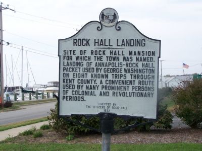
Rock Hall Landing
Erected 1932 by Citizens of Rock Hall.
Topics. This historical marker is listed in these topic lists: Colonial Era • Roads & Vehicles • Settlements & Settlers • War, US Revolutionary • Waterways & Vessels.
Location. 39° 8.029′ N, 76° 14.577′ W. Marker is in Rock Hall, Maryland, in Kent County. Marker is at the intersection of Hawthorne Street and Sharp Street, on the left when traveling east on Hawthorne Street. Touch for map. Marker is in this post office area: Rock Hall MD 21661, United States of America. Touch for directions.
Other nearby markers. At least 8 other markers are within one mile of this marker, measured as the crow flies. Bounty Below (approx. ¼ mile away); Right Place, Right Time (approx. 0.3 miles away); Attracted By Bounty (approx. 0.3 miles away); Rock Hall, Maryland (approx. half a mile away); Captain Lambert Wickes (approx. 0.6 miles away); Stanley B. Vansant Memorial (approx. 0.6 miles away); A Diversion (approx. ¾ mile away); Gratitude (approx. one mile away). Touch for a list and map of all markers in Rock Hall.
Credits. This page was last revised on November 22, 2019. It was originally submitted on October 20, 2007, by Bill Pfingsten of Bel Air, Maryland. This page has been viewed 1,569 times since then and 23 times this year. Photos: 1, 2. submitted on October 20, 2007, by Bill Pfingsten of Bel Air, Maryland. • J. J. Prats was the editor who published this page.

