Mill Creek Hundred in Newark in New Castle County, Delaware — The American Northeast (Mid-Atlantic)
White Clay Creek
A nationally recognized waterway.
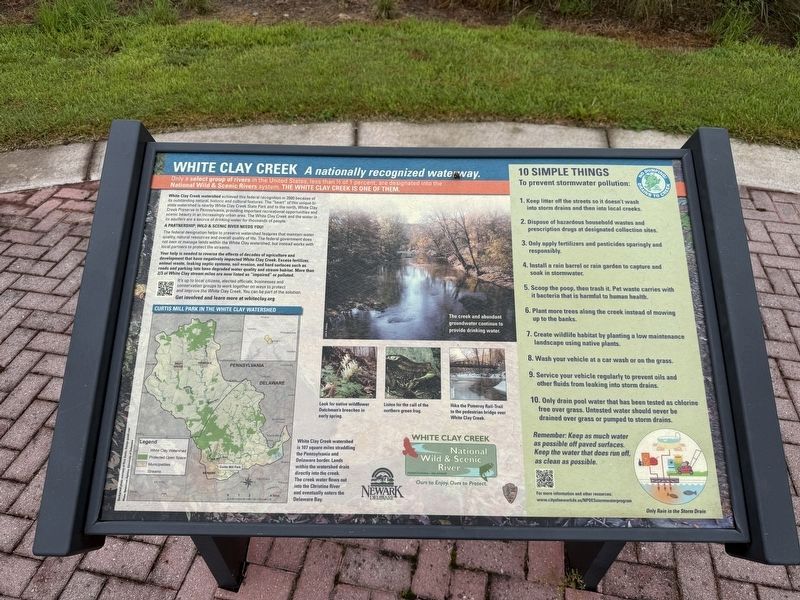
Only a select group of rivers in the United States, less than ½ of 1 percent, are designated into the National Wild & Scenic Rivers system. The White Clay Creek is one of them.
White Clay Creek watershed achieved this federal recognition in 2000 because of its outstanding natural, historic and cultural features. The "heart" of this unique bi-state watershed is nearby White Clay Creek State Park and to the north, White Clay Creek Preserve in Pennsylvania, providing important recreational opportunities and scenic beauty in an increasingly urban area. The White Clay Creek and the water in its aquifers are a source of drinking water for thousands of people.
A Partnership: Wild & Scenic River Needs You!
The federal designation helps to preserve watershed features that maintain water quality, natural resources and overall quality of life. The federal government does not own or manage lands within the White Clay watershed, but instead works with local partners to protect the streams.
Your help is needed to reverse the effects of decades of agriculture and development that have negatively impacted White Clay Creek. Excess fertilizer, animal waste, leaking septic systems, soil erosion, and hard surfaces such as roads and parking lots have degraded water quality and stream habitat. More than 2/3 of White Clay stream miles are now listed as “impaired” or polluted.
It’s
this page online
Get involved and learn more at whiteclay.org
10 simple things
To prevent stormwater pollution:
1. Keep litter off the streets so it doesn’t wash into storm drains and then into local creeks.
2. Dispose of hazardous household wastes and prescription drugs at designated collection sites.
3. Only apply fertilizers and pesticides sparingly and responsibly.
4. Install a rain barrel or rain garden to capture and soak in stormwater.
5. Scoop the poop, then trash it. Pet waste carries with it bacteria that is harmful to human health.
6. Plant more trees along the creek instead of mowing up to the banks.
7. Create wildlife habitat by planting a low maintenance landscape using native plants.
8. Wash your vehicle at a car wash or on the grass.
9. Service your vehicle regularly to prevent oils and other fluids from leaking into storm drains.
10. Only drain pool water that has been tested as chlorine free over grass. Untested watershould never be drained over grass or pumped to storm drains.
Remember: Keep as much water as possible off paved surfaces. Keep the water that does run off, as clean as possible.
[Captions:]
The creek and abundant groundwater continue to provide drinking water.
Look for wildflower Dutchman's breeches in early spring.
Listen for the call of the northern green frog.
Hike the Pomeroy Rail-Trail to the pedestrian bridge over White Clay Creek.
Only Rain in the Storm Drain
Erected by City of Newark, Delaware.
Topics. This historical marker is listed in these topic lists: Environment • Parks & Recreational Areas • Waterways & Vessels. A significant historical year for this entry is 2000.
Location. 39° 41.442′ N, 75° 45′ W. Marker is in Newark, Delaware, in New Castle County. It is in Mill Creek Hundred. It is on Old Paper Mill Road west of Paper Mill Road, on the left when traveling west. Touch for map. Marker is at or near this postal address: 225 Paper Mill Rd, Newark DE 19711, United States of America. Touch for directions.

Regionally, this marker is in Greater Wilmington and in Greater Philadelphia. It is also in the American Mid-Atlantic, on the Delmarva Peninsula, and on the Eastern Seaboard. Globally, it is in the North Atlantic Region, North America, the Western Hemisphere, the Western World, and the Anglosphere. Historically, it finds itself in what was once New Netherland and also one of the original Thirteen Colonies.
Other nearby markers. At least 8 other markers are within walking distance of this marker: Curtis Paper Mill (here, next to this marker); The Industries of Newark (approx. ¼ mile away); Preston's Playground (approx. 0.3 miles away); Mechanical Hall (approx. half a mile away); Warner & Taylor Awards (approx. half a mile away); Recitation Hall Annex (approx. half a mile away); Jastak-Burgess Hall (approx. half a mile away); University of Delaware Alumni Association (approx. half a mile away). Touch for a list and map of all markers in Newark.
Credits. This page was last revised on August 19, 2026. It was originally submitted on August 16, 2026, by Devry Becker Jones of Washington, District of Columbia. This page has been viewed 22 times since then. Photos: 1, 2. submitted on August 16, 2026, by Devry Becker Jones of Washington, District of Columbia.
