Bristol in Bristol County, Rhode Island — The American Northeast (New England)
Environmental Resiliency in Bristol
| — | ❓ | — |
Photographed by Devry Becker Jones (CC0), September 18, 2026
1. Environmental Resiliency in Bristol Marker
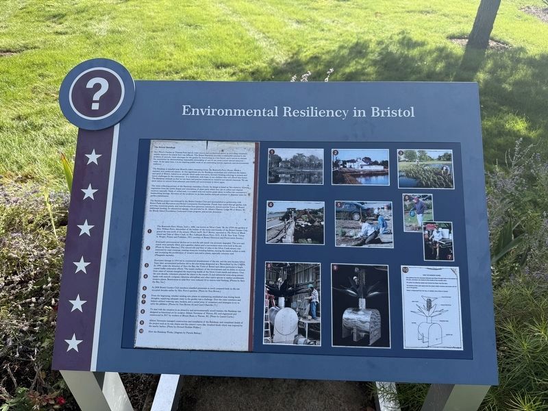
The Bristol Rainkeep
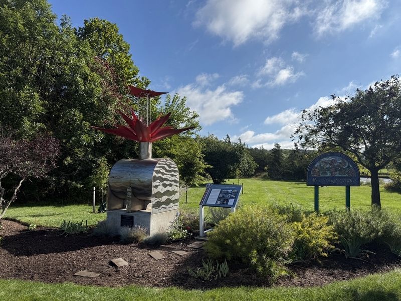
Mrs. Perry's Garden in Thomas Park had no water source and no electrical power, so providing consistent, reliable moisture for plants here was difficult. The Bristol Rainkeep provides a sustainable solution to the problem of periodic water shortages for the garden by functioning as a rain barrel; and it serves to educate the community by demonstrating responsible stewardship of one of our most critical natural resources -- water. At the same time, it is an inspiring work of art celebrating human ingenuity and environmental resiliency.
The Rainkeep is installed near Bristol's oldest remaining house, the Bosworth-Perry House, beside a restored, now preserved estuary. At this significant site the Rainkeep symbolizes and celebrates the history and spirit of Bristol, linked to an attitude which seeks innovative, forward thinking solutions to present and future challenges for the community. It is dedicated, with hope, to our children who will inherit the future. The Rainkeep reminds us that we can learn and practice measures to conserve our natural resources. We can assist nature to recover from adversity
this page online
The water collecting portion of the Rainkeep resembles a flower. Its designis based on 'bio-mimicry,' drawing inspiration from the subtle shapes and orientations of plant parts which they use to collect and channel moisture naturally. Made of rolled steel, it is coated with red marine grade epoxy to reflect the community's boatbuilding heritage. Elevation of the sculpture on its base enables adequate pressure to dispense water for garden maintenance.
The Rainkeep project was initiated by the Bristol Garden Club and accomplished in partnership with Bristol Parks and Recreation and Bristol Community Development. Funds were raised through garden club activities, numerous grants, and contributions from generous community donors and the Town of Bristol. Additional funding, for educational signage, was provided by St. Albans Masonic Lodge #6 of Bristol, RI, the Rhode Island Foundation Centennial Grant program, and private donations.
❶ The Bosworth-Perry House, built c. 1680, was known as 'Silver Creek.' By the 1920's the gardens of Mrs. William Perry, descendant of the builderof the home and founder of the Bristol Garden Club, graced the area north of the estuary. [Photo by W. De F. Brown; reprinted in The Perrys of Rhode Island and Tales of Silver Creek, by Rev. Calbraith Bourn Perry, D.D., S.A.R. New York: Tobias A. Wright, Printer and Publisher, 1913; courtesy of Bristol Historical Preservation Society.]Photographed by Devry Becker Jones (CC0), September 18, 20262. Environmental Resiliency in Bristol Marker
❷ Eventually environmental decline set in and the salt marsh was seriously degraded. The cove and marsh were partially filled, and a gasoline station and a convenience store were built at the site. [Photo by Steve Mascena.] The natural ebb and flow of tides in the Silver Creek estuary was restricted by road crossings, creating mosquito breeding habitat; causing the marsh surface to sink; and increasing the proliferation of invasive non-native plants, especially common reed (Phragmites australis).
❸ ❹ Hurricane damage in 1954 led to commercial abandonment of the site, and the area became fallow. Years later, accumulated pollution led to the area being designated as a 'Brownfield' by the USEPA. In 1999, under the direction of Save the Bay, the Town of Bristol and others partnered to begin coastal buffer restoration efforts. The innate resiliency of the environment and its ability to recover from years of misuse energized the improving health of the Silver Creek marsh and estuary. Over the next decade, volunteers planted the island in the marsh (3) and substantial areas along estuary banks with smooth cordgrass (Spartina alterniflora) and other native species to replace problematic invasive plants. Restrictions to tidal flow were reduced (4) to restore tidal flushing. [Photos by Save the Bay, Inc.]
❺ In 2008 Bristol Garden Club members installed perennials in newly prepared beds on the site occupied decades earlier by Mrs. Perry's gardens. [Photos by Vera Bowen.]
❻ ❼ From the beginning, whether tending new plants or maintaining established ones during harsh droughts, supplying adequate water to the garden was a challenge. Over the years members and helpers utilized watering cans, buckets, and a varied array of containers and strategies to try to solve the problem. [Photos by Vera Bowen (6) and Carol Glanville (7).]
❽ To deal with the situation in an attractive and environmentally sound manner, the Rainkeep was designed as functional art by sculptor Allison Newsome of Warren, RI; and engineered and constructed in 2017 by workers at Blount Boats in Warren, RI. [Photo by Laurel Curtis.]
❾ Allison Newsome managed construction and installation of the Rainkeep; and completed details of the project such as its rain chains and the cistern's wave-like brushed finish which was inspired by the nearby harbor. [Photo by Howard Rotblat-Walker.]
❿ How the Rainkeep Works; [diagram by Pamela Bishop.]
Topics. This historical marker is listed in these topic lists: Colonial Era • Environment • Horticulture & Forestry • Parks & Recreational Areas. A significant historical year for this entry is 1680.
Location. 41° 40.684′ N, 71° 16.692′ W. Marker is in Bristol, Rhode Island, in Bristol County. It is on Hope Street (Rhode Island Route 114) south of Washington Street, on the right when traveling north. Touch for map. Marker is at or near this postal address: 775 Hope St, Bristol RI 02809, United States of America. Touch for directions.

Regionally, this marker is in Greater Providence and on Narragansett Bay. It is also in the American Northeast, in New England, and on the Eastern Seaboard. Globally, it is in the North Atlantic Region, North America, the Western Hemisphere, the Western World, and the Anglosphere. Historically, it finds itself in what was once one of the original Thirteen Colonies.
Other nearby markers. At least 8 other markers are within walking distance of this marker: Silver Creek Salt Marsh (about 400 feet away, measured in a direct line); General Lafayette (approx. ¼ mile away); Memorial to Bristol Naval Veterans (approx. ¼ mile away); Liberty Tree Memorial (approx. ¼ mile away); Planted in Honor of Rhode Island's Revolutionary Legacy (approx. 0.3 miles away); The War of Independence / Honor Roll (approx. 0.3 miles away); The UNESCO Routes of Enslaved Peoples: Resistance, Liberty & Heritage (approx. 0.3 miles away); Historical Hurricane Flooding (approx. 0.3 miles away). Touch for a list and map of all markers in Bristol.
Credits. This page was last revised on September 24, 2026. It was originally submitted on September 24, 2026, by Devry Becker Jones of Washington, District of Columbia. This page has been viewed 8 times since then. Photos: 1, 2. submitted on September 24, 2026, by Devry Becker Jones of Washington, District of Columbia.
