Portsmouth in Newport County, Rhode Island — The American Northeast (New England)
The Garden of New England
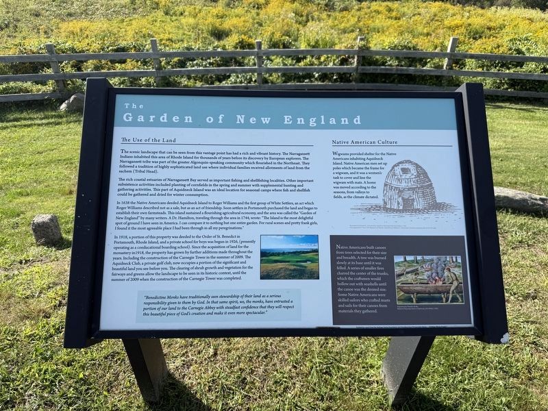
The Use of the Land
The scenic landscape that can be seen from this vantage point has had a rich and vibrant history. The Narragansett Indians inhabited this area of Rhode Island for thousands of years before its discovery by European explorers. The Narragansett tribe was part of the greater Algonquin-speaking community which flourished in the Northeast. They followed a tradition of highly sophisticated land use where individual families received allotments of land from the sachem (Tribal Head).
The rich coastal estuaries of Narragansett Bay served as important fishing and shellfishing localities. Other important subsistence activities included planting of cornfields in the spring and summer with supplemental hunting and gathering activities. This part of Aquidneck Island was an ideal location for seasonal camps where fish and shellfish could be gathered and dried for winter consumption.
In 1638 the Native Americans deeded Aquidneck Island to Roger Williams and the first group of White Settlers, an act which Roger Williams described not as a sale, but as an act of friendship. Soon settlers in Portsmouth purchased
this page online
In 1918, a portion of this property was deeded to the Order of St. Benedict in Portsmouth, Rhode Island, and a private school for boys was begun in 1926, (presently operating as a coeducational boarding school). Since the acquisition of land for the monastery in 1918, the property has grown by further additions made throughout the years. Including the construction of the Carnegie Tower in the summer of 2009. The Aquidneck Club, a private golf club, now occupies a portion of the significant and beautiful land you see before you. The clearing of shrub growth and vegetation for the fairways and greens allow the landscape to be seen in its historic context,
“Benedictine Monks have traditionally seen stewardship of their land as a serious responsibility given to them by God. In that same spirit, we, the monks, have entrusted a portion of our land to the Carnegie Abbey with steadfast confidence that they will respect this beautiful piece of God’s creation and make it even more spectacular.”
Native American Culture
Wigwams provided shelter for the Native Americans inhabiting Aquidneck Island. Native American men set up poles which became the frame for a wigwam, and it was a women’s task to cover and line the wigwam with mats. A home was moved according to the seasons, from valleys to fields, as the climate dictated.
Native Americans built canoes from trees selected for their size and breadth. A tree was burned slowly at its base until it was felled. A series of smaller fires charred the center of the trunks, which the craftsmen would hollow out with seashells until the canoe was the desired size. Some Native Americans were skilled sailors who crafted masts and sails for their canoes from materials they gathered.
Topics. This historical marker is listed in these topic lists: Agriculture • Colonial Era • Indigenous Peoples and Communities • Religion & Religious Structures. A significant historical year for this entry is 1638.
Location. 41° 36.679′ N, 71° 15.625′ W. Marker is in Portsmouth, Rhode Island, in Newport County. It is on West Main Road (Rhode Island Route 114) south of Willow Lane, on the right when traveling south. Touch for map. Marker is at or near this postal address: 158 W Main Rd, Portsmouth RI 02871, United States of America. Touch for directions.

Regionally, this marker is on Narragansett Bay and in Newport and Aquidneck Island. It is also in the American Northeast, in New England, and on the Eastern Seaboard. Globally, it is in the North Atlantic Region, North America, the Western Hemisphere, the Western World, and the Anglosphere. Historically, it finds itself in what was once one of the original Thirteen Colonies.
Other nearby markers. At least 8 other markers are within 2 miles of this marker, measured as the crow flies: The Battle of Rhode Island - 1778 (here, next to this marker); Butts Hill Fort (approx. 0.6 miles away); The 1st Rhode Island Regiment and the Battle of Rhode Island (approx. 0.7 miles away); Site of the Battle of Rhode Island (approx. 0.7 miles away); The Black Regiment (approx. 0.7 miles away); Sri Chinmoy Peace Town (approx. 1.3 miles away); Portsmouth Compact (approx. 1.3 miles away); Anne Hutchinson/Mary Dyer Memorial Herb Garden (approx. 1.3 miles away). Touch for a list and map of all markers in Portsmouth.
Other markers no longer nearby. The Battle of Rhode Island - 1778 (was here, next to this marker but has been replaced with another marker now near it); a different marker also named Garden of New England (was a few steps from this marker but has been replaced with another marker now near it).
Credits. This page was last revised on September 27, 2026. It was originally submitted on September 27, 2026, by Devry Becker Jones of Washington, District of Columbia. This page has been viewed 4 times since then. Photos: 1, 2. submitted on September 27, 2026, by Devry Becker Jones of Washington, District of Columbia.
