Johns Creek in Fulton County, Georgia — The American South (South Atlantic)
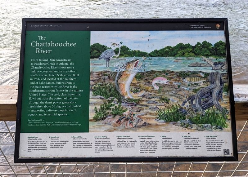
The Chattahoochee River
| — | Chattahoochee River National Recreation Area | — |
September 28, 2023
1. The Chattahoochee River Marker
Sign made possible by:
Upper Chattahoochee Chapter of Trout Unlimited (ucctu.org) and Chattahoochee National Park Conservancy (chattahoocheeparks.org).
(caption) 1. Rainbow Trout (Oncorhynchus mykiss) Stocked throughout the year in the Chattahoochee River, this cold water fish requires water temperatures to be consistently below 65 degrees Fahrenheit to thrive.
(caption) 2. Brown Trout (Salmo trutta) The cold, clear water supports a wild, reproducing brown trout population in the Chattahoochee River.
(caption) 3. Bluehead Chub (Nocomis leptocephalus) Male bluehead chubs build gravel mounds for females to lay their eggs and are often used for habitat by other aquatic species.
(caption) 4. American Bullfrog (Lithobates catesbeianus) The call of the American bullfrog is a distinctive on a southern summer night, but not many people know that they are voracious predators that can consume small birds and rodents.
(caption) 5. Spotted Salamander (Ambystoma maculatum) Although large for a salamander, these critters are hard to spot, but if you do find one it would indicate a healthy ecosystem.
(caption) 6. Chattahoochee Crayfish (Cambarus howardi) Regularly found in the northern portion of the Chattahoochee River watershed, this crayfish with bluish-green coloration can be found in riffle habitat from the smaller tributary streams to the main river.
(caption) 7. Mayfly (Ephemeroptera) A vital food source for fish, these insects spend most of their lifecycle underwater as nymphs and can live for several years before they hatch as adults.
(caption) 8. Shoal Bass (Micropterus cataractae) Identified in 1999, the shoal bass is one of ten black bass found in the state of Georgia and is native to the Chattahoochee River.
(caption) 9. Great Blue Heron (Ardea herodias) The Great Blue Heron is the largest of the North American herons and often stalks the shallows of the riverbank, waiting for fish to swim within striking distance.
Erected by National
this page online
Topics. This historical marker is listed in these topic lists: Animals • Environment • Parks & Recreational Areas • Waterways & Vessels. A significant historical year for this entry is 1956.
Location. 34° 0.056′ N, 84° 14.218′ W. Marker is in Johns Creek, Georgia, in Fulton County. It can be reached from no nearby street. Located near the Jones Bridge North Trailhead Parking. Touch for map. Marker is in this post office area: Alpharetta GA 30022, United States of America. Touch for directions.

Regionally, this marker is in the Piedmont and in Metro Atlanta. It is also in the American South and specifically in the Deep South. Globally, it is in North America, the Western Hemisphere, the Western World, and the Anglosphere. Historically, it finds itself in what was once the territory of the Mississippian Culture, one of the original Thirteen Colonies, one of the Confederate States of America, and the Antebellum South.
Other nearby markers. At least 8 other markers are within 5 miles of this marker, measured as the crow flies: State R.R. Survey (approx. 2.1 miles away); Garrard Landing Park (approx. 2.4 miles away); "Holy Row" (approx. 4.1 miles away); Site of Norcross Public Library (approx. 4.2 miles away); You are standing on the Eastern Continental Divide (approx. 4.2 miles away); Historic Baptist Church (approx. 4.2 miles away); Thrasher Park (approx. 4.2 miles away); Brunswick Hotel (approx. 4.2 miles away).
Credits. This page was last revised on November 6, 2026. It was originally submitted on October 3, 2026. This page has been viewed 19 times since then. Photo 1. submitted on October 3, 2026. • Andrew Ruppenstein was the editor who published this page.
