Richmond in Washington County, Rhode Island — The American Northeast (New England)
Post-Glaciation and Native Peoples
| — | Richmond Heritage Trail | — |
Photographed by Devry Becker Jones, September 17, 2026
1. Post-Glaciation and Native Peoples Marker
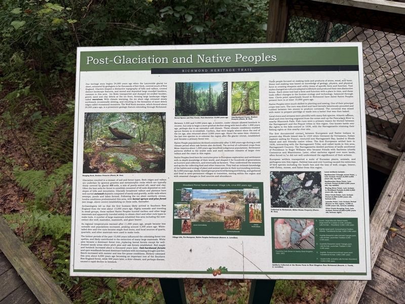
Our heritage story begins 26,000 years ago when the Laurentide glacial ice sheet, estimated by geologists to be thousands of feet thick, covered much of New England. Glaciers shaped a distinctive topography of hills and valleys, created distinct landscape features, and moved and deposited large rounded boulders, common to this area. Ice flows transported and dumped unsorted boulders, gravel, sand and clay debris at the ice front, forming large landscape ridges called moraines. With climatic warming, the ice sheet edge retreated slowly northward, occasionally slowing, and resulting in the formation of more debris ridges called recessional moraines. The Wolf Rock moraine, which formed about 26,000 years ago, is a prominent geologic feature extending through Richmond.
Glaciation resulted in a mosaic of soil and forest types. Both ridges and valleys are underlain by igneous granites and metamorphic rocks which are typically thinly covered by glacial till soils, a mix of poorly-sorted silt, sand and clay. Often the best soils for forest to establish consisted of silt soils deposited on mid-slopes of hills and mountains.
this page online
Archaeologists tell us that the first humans likely arrived in Southern New England from the west about 13,000 years ago. Highly nomadic and traveling in small groups, these earliest Native Peoples hunted caribou and other large mammals and apparently traveled widely to obtain chert and other rock types to make tools. A number of large mammals inhabited this area including the now-extinct dire wolf, mastodon, mammoth, and giant beaver.
As regional temperatures warmed after 11,000 years ago, people became less nomadic and populations increased, peaking around 5,500 years ago. White-tailed deer and tree nuts became staple food items, and local sources of quartz, quartzite, and other materials were used to make tools.
The hottest periods of the past 10,000 years influenced the colonizing forest
Photographed by Devry Becker Jones (CC0), September 17, 2026
2. Post-Glaciation and Native Peoples Marker
Between 3,500 and 6,000 years ago, a moister, cooler climate allowed hemlock to recover, but only to begin a more gradual decline along with beech after 1,000 years ago, perhaps due to an extended cold climate. These climatic conditions enabled spruce forests to re-establish. Caribou, that had been largely absent since the end of the Ice Age, also returned about 2,000 years ago. About the same time, chestnut, the last tree species to re-colonize the region after the glacier retreat, established and became a primary forest tree.
Native People populations declined considerably after 3,500 years ago during a cold climatic period when oak forests also declined. The arrival of cultivated crops from Meso America about 1,000 years ago benefited indigenous populations. Settlement patterns shifted to the arable soils and more moderate climates of larger river valleys and the coast in this region.
Native Peoples lived here for centuries prior to European exploration and settlement with in-depth knowledge of their world, and shaped it for hundreds of generations as hunters and collectors, and eventually as farmers. They understood the seasons and cycles for collecting food and other resources. They had an intimate knowledge of the habits and ecology of plant and animal species in their surrounding environments. By 3,000 years ago, family-based groups practiced farming and fishing, and gathered and lived in semi-permanent villages in transition, moving within the region and with seasonal changes in food sources and abundance.
These people focused on making tools and products of stone, wood, and bone. Stone-tool-making was based on knowledge of geology, physics, and physical force in creating weapons and utility items of specific form and function. Tool styles changed as cultures adapted to lifestyle and produced their own distinctive forms. Each stone tool had a form and function with a place in time, and these tools reflect changes in the human ecology and technology, balanced through time. Clovis point spearheads found in Richmond have dated Native Peoples present here to at least 10,000 years ago.
Native Peoples were much skilled in planting and sewing. One of their principal crops was corn. The corn was dried and hard kernels laboriously pounded and rubbed between two stones to produce cornmeal. The cornmeal was mixed with water to prepare porridge or made into a batter that was then baked.
Local rivers and streams were plentiful with many fish species. Atlantic salmon, shad and river herring migrated from the ocean and up the Pawcatuck River to nearby Shamwock Falls. Fish runs were a primary reason for friction between the Narragansett and the Pequot tribes in this region. One known battle over the rights to the falls ensued in 1636, with the Narragansetts retaining their fishing rights at this nearby river site.
The first documented contact between Europeans and Native Indians in present-day Rhode Island was in 1524 when Giovanni da Verrazzano, Italian explorer sailing for France, ventured into Narragansett Bay, landed in Rhode Island and met friendly native tribes. The first Europeans settled here in 1636, interacting with the Narragansett Tribe, and called lands in this area Narragansett Country. The Narragansetts deeded portions of lands southwest of Providence to Roger Williams who became friends with Sachems (chiefs) Canonicus and Miantonomi. Later, other sachems signed over more lands, often forced to, or did not well understand the significance of their actions.
European settlers transported a suite of Eurasian plants, animals, and pathogens into this region. Habitat loss and over hunting caused the extinction of bird species including the heath hen and the loss of wolf, cougar, beaver, wild turkey, moose, and fisher from this region.
Erected by Town of Richmond, Rhode Island.
Topics. This historical marker is listed in these topic lists: Anthropology & Archaeology • Colonial Era • Indigenous Peoples and Communities • Settlements & Settlers. A significant historical year for this entry is 1636.
Location. 41° 30.29′ N, 71° 39.895′ W. Marker is in Richmond, Rhode Island, in Washington County. It is on Richmond Heritage Trail north of Country Acres Road, on the right when traveling north. Touch for map. Marker is at or near this postal address: 3 Country Acrs Rd, Wyoming RI 02898, United States of America. Touch for directions.

Regionally, this marker is on Narragansett Bay and in South County. It is also in the American Northeast, in New England, and on the Eastern Seaboard. Globally, it is in the North Atlantic Region, North America, the Western Hemisphere, the Western World, and the Anglosphere. Historically, it finds itself in what was once one of the original Thirteen Colonies.
Other nearby markers. At least 8 other markers are within 3 miles of this marker, measured as the crow flies: Early European Settlement (about 300 feet away, measured in a direct line); Early Town of Richmond (about 400 feet away); A Maturing Town (about 500 feet away); Richmond: A Town with Vision of Its Heritage and History (about 600 feet away); Recent Times and the Future of Richmond (about 600 feet away); World War I, World War II and the Korean Campaign Memorial (approx. half a mile away); Vietnam and Desert Storm Memorial (approx. half a mile away); Depot Square Park (approx. 2.7 miles away). Touch for a list and map of all markers in Richmond.
Credits. This page was last revised on October 3, 2026. It was originally submitted on October 3, 2026, by Devry Becker Jones of Washington, District of Columbia. This page has been viewed 4 times since then. Photos: 1, 2. submitted on October 3, 2026, by Devry Becker Jones of Washington, District of Columbia.
