Kyneton in Macedon Ranges Shire, Victoria, Australia — Oceania
Greetings to Taungurung Country - Northern Marker
Photographed by Dean Barton-Ancliffe, August 31, 2026
1. Greetings to Taungurung Country Marker
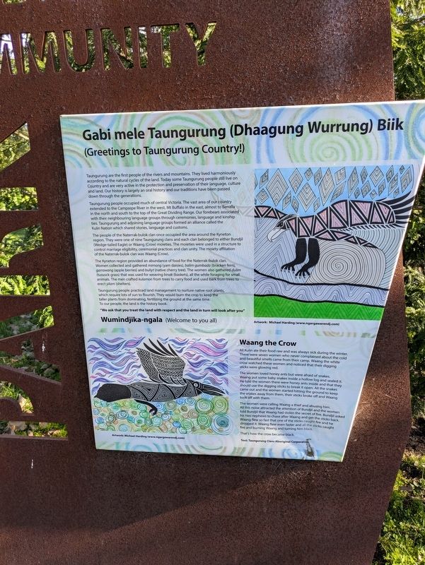
(Greetings to Taungurung Country!)
Taungurung are the first people of the rivers and mountains. They lived harmoniously according to the natural cycles of the land. Today some Taungurung people still live on Country and are very active in the protection and preservation of their language, culture and land. Our history is largely an oral history and our traditions have been passed down through the generations.
Taungurung people occupied much of central Victoria. The vast area of our country extended to the Campaspe River in the west, Mt Buffalo in the east, almost to Benalla in the north and south to the top of the Great Dividing Range. Our forebears associated with their neighbouring language groups through ceremonies, language and kinship ties. Taungurung and adjoining language groups formed an alliance called the Kulin Nation which shared stories, language and customs.
The people of the Naterrak-bulok clan once occupied the area around the Kyneton region. They were one of nine Taungurung clans and each clan belonged to either Bundjil (Wedge-tailed Eagle) or Waang
this page online
The Kyneton region provided an abundance of food for the Naterrak-bulok clan. Women collected and gathered mirnong (yam daisies), balim gumbada (bracken fern), garrawang (apple berries) and buliyt (native cherry tree). The women also gathered dulim (tussock grass) that was used for weaving binak (baskets), all the while foraging for small animals. The men crafted kulamon from trees to carry food and used bark from trees to erect yilam (shelters).
Taungurung people practiced land management to nurture native root plants, which require lots of sun to flourish. They would burn the crop to keep the taller plants from dominating, fertilizing the ground at the same time. To our people, the land is the history book.
"We ask that you treat the land with respect and the land in turn will look after you"
Wumindjika-ngala (Welcome to you all)
Waang the Crow
All Kulin ate their food raw and was always sick during the winter. There were seven

Photographed by Dean Barton-Ancliffe, August 31, 2026
2. Greetings to Taungurung Country - Northern Marker in the Park
The women loved honey ants but were afraid of snakes. Waang put some baby snakes inside a hollow log and sealed it. He told the women there were honey ants inside and that they should use the digging sticks to break it open. All the snakes came out and the women started hitting the ground to keep the snakes away from them, their sticks broke off and Waang took off with them.
The women were calling Waang a thief and abusing him. All this noise attracted the attention of Bundjil and the women told Bundjil that Waang had stolen the secret of fire. Bundjil asked his two nephews to chase after Waang and get the sticks back. Waang flew so fast that one of the sticks caught fire and he dropped it. Waang flew even faster and all the sticks caught fire and burning Waang and turning him black.
That's how the crow became black.
Topics. This historical marker is listed in these topic lists: Indigenous Peoples and Communities • Parks & Recreational Areas • Women.
Location. 37° 15.204′ S, 144° 26.976′ E. Marker is in Kyneton, Victoria, in Macedon Ranges Shire. It is at the intersection of Clowes Street and Ebden Street, on the left when traveling west on Clowes Street. Touch for map. Marker is at or near this postal address: 14 Clowes Street, Kyneton VIC 3444, Australia. Touch for directions.

Regionally, it is in Oceania, in Australasia, in the Pacific Ocean, in South Pacific, on the Pacific Rim, in the Western World, and in the Anglosphere. Historically, it finds itself in what was once a British colony.
Other nearby markers. At least 8 other markers are within walking distance of this marker: Gabi mele Taungurung (Daagung Wurrung) Biik (about 90 meters away, measured in a direct line); Kyneton Botanical Gardens (about 240 meters away); Centenary of the Shire of Kyneton (approx. 0.2 kilometers away); McKenna Memorial Drive (approx. 0.3 kilometers away); Kyneton Old Scholars War Memorial (approx. half a kilometer away); Kyneton War Memorial (approx. 0.6 kilometers away); Kyneton Destinations (approx. 0.6 kilometers away); Kyneton Court House (approx. 0.7 kilometers away). Touch for a list and map of all markers in Kyneton.
Credits. This page was last revised on October 13, 2026. It was originally submitted on October 11, 2026, by Dean Barton-Ancliffe of Rowville, Victoria. This page has been viewed 11 times since then. Photos: 1, 2. submitted on October 11, 2026, by Dean Barton-Ancliffe of Rowville, Victoria. • Andrew Ruppenstein was the editor who published this page.
