Melton Mowbray in Leicestershire, England, United Kingdom — Northwestern Europe (the British Isles)
Melton Mowbray Town Estate
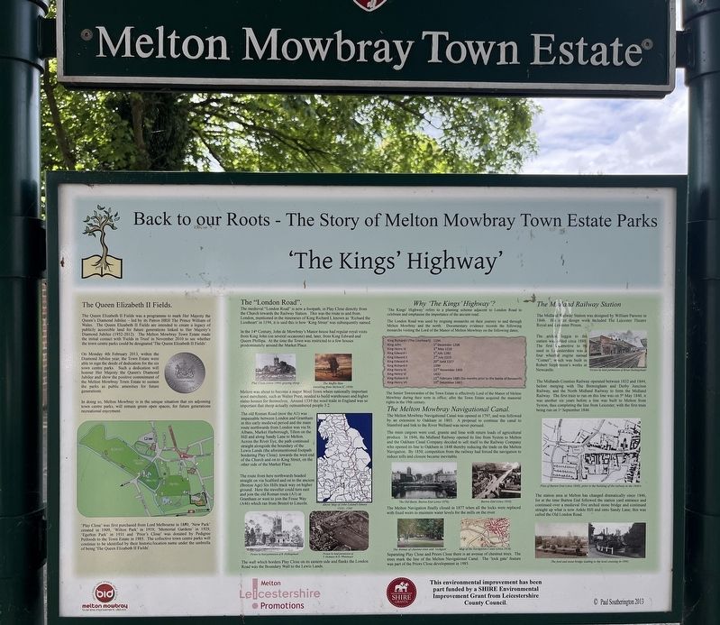
Back to our Roots - The Story of Melton Mowbray Town Estate Parks
| — | The Kings' Highway | — |
Photographed by Ray Gurganus, May 5, 2026
1. Melton Mowbray Town Estate Marker
The Queen Elizabeth II Fields.
The Queen Elizabeth II Fields was a programme to mark Her Majesty the Queen's Diamond Jubilee - led by its Patron HRH The Prince William of Wales. The Queen Elizabeth II Fields are intended to create a legacy of publicly accessible land for future generations linked to Her Majesty's Diamond Jubilee (1952-2012). The Melton Mowbray Town Estate made the initial contact with 'Fields in Trust' in November 2010 to see whether the town centre parks could be designated 'The Queen Elizabeth II Fields'.
On Monday 4th February 2013, within the Diamond Jubilee year, the Town Estate were able to sign the deeds of dedication for the six town centre parks. Such a dedication will honour Her Majesty the Queen's Diamond Jubilee and show the positive commitment of the Melton Mowbray Town Estate to sustain the parks as public amenities for future generations.
In doing so, Melton Mowbray is in the unique situation that six adjoining town centre parks, will remain green open spaces, for future generations recreational enjoyment.
'Play Close' was first purchased from Lord Melbourne in 1850, 'New Park'
this page online
The "London Road".
The medieval "London Road" is now a footpath; in Play Close directly from the Church towards the Railway Station. This was the route to and from London, mentioned in the itineraries of King Richard I, known as 'Richard the Lionheart' in 1194, it is said this is how 'King Street' was subsequently named.
In the 14th Century, John de Mowbray's Manor house had regular royal visits from King John (on several occasions) and, later, from King Edward and Queen Phillipa. At the time the Town was restricted to a few houses prodominately around the Market Place.
Melton was about to become a major Wool Town where nationally important wool merchants, such as Walter Prest, needed to build warehouses and higher status houses for themselves. Around 1339 the wool trade in England was so important that sheep actually outnumbered people 3:2.
The old Roman Road (now the A1) was impassable between London and Grantham in this early medieval period and the main route northwards from London was via St. Albans, Market Harborough, Tilton on the Hill and along Sandy Lane to Melton. Across the River Eye, the path continued straight alongside the boundary of the Lewis Lands (the aforementioned footpath bordering Play Close) towards the west end of the Church and on to King Street, on the other side of the Market Place.
The route from here northwards headed straight on via Scalford and on to the ancient (Bronze Age) Six Hills track way on higher ground. Here the traveller could turn east and join the old Roman route (Al) at Grantham or west to join the Fosse Way (A46) which ran from Bristol to Lincoln.
The wall which borders Play Close on its eastern side and flanks the London Road was the Boundary Wall to the Lewis Lands.
Why 'The Kings' Highway'?
'The Kings' Highway' refers to a planting scheme adjacent to London Road to celebrate and emphasise the importance of the ancient road.
The London Road was used by reigning monarchs on their journey to and through Melton Mowbray and the north. Documentary evidence records the following monarchs visiting the Lord of the Manor of Melton Mowbray on the following dates;
• King Richard I (The Lionheart), 1194.
• King John, 1 December 1208
• King Henry III, 3rd May 1218
• King Edward I, 1 July 1282
• King Edward II, 2nd July 1323
• King Edward III, 20th June 1327
• King Richard II, 1399
• King Henry IV, 22nd November 1403
• King Henry VI, 1432
• King Richard III, 12th February 1485 (Six months prior to the Battle of Bosworth)
• King Henry VII, 10th December 1487
The Senior Townwarden of the Town Estate is effectively Lord of the Manor of Melton Mowbray during their term in office; after the Town Estate acquired the manorial rights in the 19th century.
The Melton Mowbray Navigational Canal.
The Melton Mowbray Navigational Canal was opened in 1797, and was followed by an extension to Oakham in 1803. A proposal to continue the canal to Stamford and link to the River Welland was never pursued.
The main cargoes were coal, granite and lime with return loads of agricultural produce. In 1846, the Midland Railway opened its line from Syston to Melton and the Oakham Canal Company decided to sell itself to the Railway Company who opened its line to Oakham in 1848 thereby reducing the trade on the Melton Navigation. By 1850, competition from the railway had forced the navigation to reduce tolls and closure became inevitable.
The Melton Navigation finally closed in 1877 when all the locks were replaced with fixed weirs to maintain water levels for the mills on the river.
Separating Play Close and Priors Close there is an avenue of chestnut trees. The trees mark the line of the Melton Navigational Canal. The 'lock gate' feature was part of the Priors Close development in 1985.
The Midland Railway Station
The Midland Railway Station was designed by William Parsons in 1846. His other design work included The Leicester Theatre Royal and Leicester Prison.
The arched loggia to the station was added circa 1880. The first locamotive to be used in Leicestershire was a four wheeled engine named "Comet", which was built in Robert Stephenson's works at Newcastle.
The Midlands Counties Railway operated between 1832 and 1844, before merging with The Birmingham and Derby Junction Railway, and the North Midland Railway to form the Midland Railway. The first train to run on this line was on 5ª May 1840, it was another six years before a line was built to Melton from Syston, thus completing the line from Leicester, with the first train being run on 1st September 1846.
The station area at Melton has changed dramatically since 1846, for at the time Burton End followed the station yard entrance and continued over a medieval five arched stone bridge and continued straight up what is now Ankle Hill and onto Sandy Lane; this was called the Old London Road.
Topics. This historical marker is listed in these topic lists: Parks & Recreational Areas • Railroads & Streetcars • Roads & Vehicles • Waterways & Vessels.
Location. 52° 45.735′ N, 0° 53.171′ W. Marker is in Melton Mowbray, England, in Leicestershire. It is on Burton Street. The marker is by the entrance to Wilton Park, next to the car park. Touch for map. Marker is at or near this postal address: 34 Burton Street, Melton Mowbray, England LE13 1AF, United Kingdom. Touch for directions.

Regionally, this marker is in the Midlands. Globally, it is on the Atlantic Ocean, in the North Atlantic Region, in Europe, in Atlantic Europe, on one of the British Isles, in the Western World, and in the Anglosphere. Historically, it finds itself in what was once the Roman Empire.
Other nearby markers. At least 8 other markers are within 14 kilometers of this marker, measured as the crow flies: A different marker also named Melton Mowbray Town Estate (here, next to this marker); The London Road (about 90 meters away, measured in a direct line); a different marker also named Melton Mowbray Town Estate (about 90 meters away); Burton Street (about 150 meters away); a different marker also named Melton Mowbray Town Estate (approx. 0.3 kilometers away); King Street (approx. 0.3 kilometers away); The Medieval Garden King Street (approx. 0.3 kilometers away); Hudson's Cottage (approx. 14.5 kilometers away). Touch for a list and map of all markers in Melton Mowbray.
Credits. This page was last revised on November 4, 2026. It was originally submitted on October 15, 2026, by Ray Gurganus of Washington, District of Columbia. This page has been viewed 4 times since then. Photo 1. submitted on October 15, 2026, by Ray Gurganus of Washington, District of Columbia. • Andrew Ruppenstein was the editor who published this page.
Editor’s want-list for this marker. photo of the marker within its surroundings • Can you help?
