
King's Lynn in Norfolk, England, United Kingdom — Northwestern Europe (the British Isles)
Ferry Lane
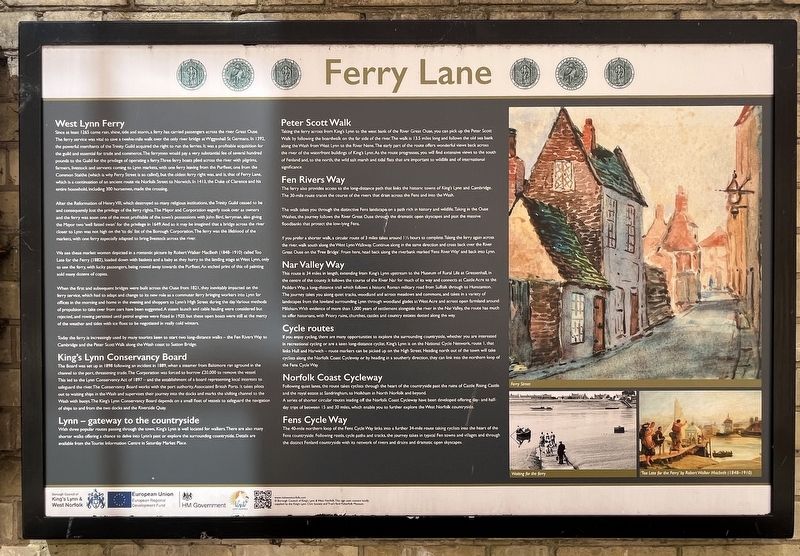
Photographed by Ray Gurganus, April 29, 2026
1. Ferry Lane Marker
West Lynn Ferry
Since at least 1265 come rain, shine, tide and storm, a ferry has carried passengers across the river Great Ouse. The ferry service was vital to save a twelve-mile walk over the only river bridge at Wiggenhall St Germans. In 1392, the powerful merchants of the Trinity Guild acquired the right to run the ferries. It was a profitable acquisition for the guild and essential for trade and commerce. The ferrymen would pay a very substantial fee of several hundred pounds to the Guild for the privilege of operating a ferry. Three ferry boats plied across the river with pilgrims, farmers, livestock and servants coming to Lynn markets, with one ferry leaving from the Purfleet, one from the Common Staithe (which is why Ferry Street is so called), but the oldest ferry right was, and is, that of Ferry Lane, which is a continuation of an ancient route via Norfolk Street to Norwich. In 1413, the Duke of Clarence and his entire household, including 300 horsemen, made the crossing.
After the Reformation of Henry VIII, which destroyed so many religious institutions, the Trinity Guild ceased to be and consequently lost
this page online
We see these market women depicted in a romantic picture by Robert Walker MacBeth (1848-1910) called Too Late for the Ferry (1882), loaded down with baskets and a baby as they hurry to the landing stage at West Lynn, only to see the ferry, with lucky passengers, being rowed away towards the Purfleet. An etched print of this oil painting sold many dozens of copies.
When the first and subsequent bridges were built across the Ouse from 1821, they inevitably impacted on the ferry service, which had to adapt and change to its new role as a commuter ferry bringing workers into Lynn for offices in the morning and home in the evening and shoppers to Lynn's High Street during the day. Various methods of propulsion to take over from oars have been suggested. A steam launch and cable hauling were considered but rejected, and rowing persisted until petrol engines were fitted in 1920, but these open boats were still at the mercy of the weather and tides with ice floes to be negotiated in really cold winters.
Today the ferry is increasingly used by many tourists keen to start two long-distance walks - the Fen Rivers Way to Cambridge and the Peter Scott Walk along the Wash coast to Sutton Bridge.
King's Lynn Conservancy Board
The Board was set up in 1898 following an incident in 1889, when a steamer from Baltimore ran aground in the channel to the port, threatening trade. The Corporation was forced to borrow £20,000 to remove the vessel. This led to the Lynn Conservancy Act of 1897 - and the establishment of a board representing local interests to safeguard the river. The Conservancy Board works with the port authority, Associated British Ports. It takes pilots out to waiting ships in the Wash and supervises their journey into the docks and marks the shifting channel to the Wash with buoys. The King's Lynn Conservancy Board depends on a small fleet of vessels to safeguard the navigation of ships to and from the two docks and the Riverside Quay.
Lynn - gateway to the countryside
With three popular routes passing through the town, King's Lynn is well located for walkers. There are also many shorter walks offering a chance to delve into Lynn's past or explore the surrounding countryside. Details are available from the Tourist Information Centre in Saturday Market Place.
Peter Scott Walk
Taking the ferry across from King's Lynn to the west bank of the River Great Ouse, you can pick up the Peter Scott Walk by following the boardwalk on the far side of the river. The walk is 13.5 miles long and follows the old sea bank along the Wash from West Lynn to the River Nene. The early part of the route offers wonderful views back across the river of the waterfront buildings of King's Lynn. As the route progresses, you will find extensive views to the south of Fenland and, to the north, the wild salt marsh and tidal flats that are important to wildlife and of international significance.
Fen Rivers Way
The ferry also provides access to the long-distance path that links the historic towns of King's Lynn and Cambridge. The 30-mile route traces the course of the rivers that drain across the Fens and into the Wash.
The walk takes you through the distinctive Fens landscape on a path rich in history and wildlife. Taking in the Ouse Washes, the journey follows the River Great Ouse through the dramatic open skyscapes and past the massive floodbanks that protect the low-lying Fens.
If you prefer a shorter walk, a circular route of 3 miles takes around 1 ½ hours to complete. Taking the ferry again across the river, walk south along the West Lynn Walkway, Continue along in the same direction and cross back over the River Great Ouse on the 'Free Bridge'. From here, head back along the riverbank marked 'Fens River Way' and back into Lynn.
Nar Valley Way
This route is 34 miles in length, extending from King's Lynn upstream to the Museum of Rural Life at Gressenhall, in the centre of the county. It follows the course of the River Nar for much of its way and connects at Castle Acre to the Peddars Way, a long-distance trail which follows a historic Roman military road from Suffolk through to Hunstanton. The journey takes you along quiet tracks, woodland and across meadows and commons, and takes in a variety of landscapes from the lowland surrounding Lynn through woodland glades at West Acre and across open farmland around Mileham. With evidence of more than 1,000 years of settlement alongside the river in the Nar Valley, the route has much to offer historians, with Priory ruins, churches, castles and country estates dotted along the way.
Cycle routes
If you enjoy cycling, there are many opportunities to explore the surrounding countryside, whether you are interested In recreational cycling or are a keen long-distance cyclist. King's Lynn is on the National Cycle Network, route 1, that links Hull and Harwich - route markers can be picked up on the High Street. Heading north out of the town will take cyclists along the Norfolk Coast Cycleway or by heading in a southerly direction, they can link into the northern loop of the Fens Cycle Way.
Norfolk Coast Cycleway
Following quiet lanes, the route takes cyclists through the heart of the countryside past the ruins of Castle Rising Castle and the royal estate at Sandringham, to Holkham in North Norfolk and beyond. A series of shorter circular routes leading off the Norfolk Coast Cycleway have been developed offering day- and half-day trips of between 15 and 30 miles, which enable you to further explore the West Norfolk countryside.
Fens Cycle Way
The 40-mile northern loop of the Fens Cycle Way links into a further 34-mile route taking cyclists into the heart of the Fens countryside. Following roads, cycle paths and tracks, the journey takes in typical Fen towns and villages and through the distinct Fenland countryside with its network of rivers and drains and dramatic open skyscapes.
Erected by Borough Council of King's Lynn & West Norfolk.
Topics. This historical marker is listed in these topic lists: Parks & Recreational Areas • Roads & Vehicles • Waterways & Vessels. A significant historical year for this entry is 1265.
Location. 52° 45.31′ N, 0° 23.617′ E. Marker is in King's Lynn, England, in Norfolk. It is at the intersection of Ferry Lane and King Street on Ferry Lane. Touch for map. Marker is at or near this postal address: 23-25 King's Staithe Square, King's Lynn, England PE30 1DU, United Kingdom. Touch for directions.

Regionally, this marker is in East Anglia. Globally, it is on the Atlantic Ocean, in the North Atlantic Region, in Europe, in Atlantic Europe, on one of the British Isles, in the Western World, and in the Anglosphere. Historically, it finds itself in what was once the Roman Empire and also the Hanseatic League.
Other nearby markers. At least 8 other markers are within walking distance of this marker: 23-25 King Street (a few steps from this marker); Corpus Christi Guildhall (a few steps from this marker); 27 King Street (a few steps from this marker); 7-9 King Street (about 90 meters away, measured in a direct line); Captain Alexander Musgrave (about 120 meters away); Captain George Vancouver (about 150 meters away); Baker Lane Oil Cake Mill (about 210 meters away); Welcome to King's Lynn (approx. 0.2 kilometers away). Touch for a list and map of all markers in King's Lynn.
Credits. This page was last revised on November 19, 2026. It was originally submitted on November 14, 2026, by Ray Gurganus of Washington, District of Columbia. This page has been viewed 6 times since then. Photo 1. submitted on November 14, 2026, by Ray Gurganus of Washington, District of Columbia. • Andrew Ruppenstein was the editor who published this page.
Editor’s want-list for this marker. photo of the marker within its surroundings • Can you help?
