
Town of Greenfield near Baraboo in Sauk County, Wisconsin — The American Midwest (Great Lakes)
The Rest of the Man Mound
Photographed by McGhiever, June 21, 2022
1. The Rest of the Man Mound Marker
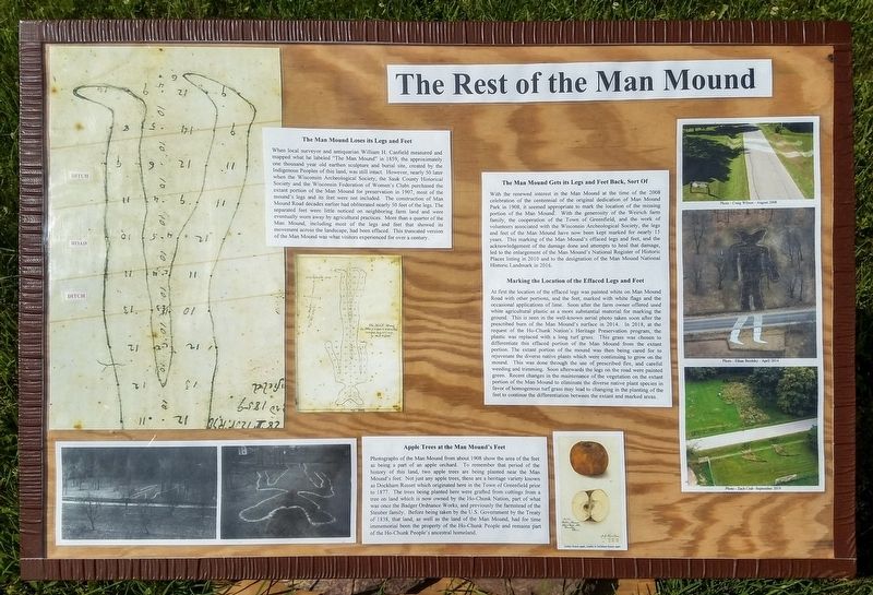
When local surveyor and antiquarian William H. Canfield measured and mapped what he labeled "The Man Mound" in 1859, the approximately one thousand year old earthen sculpture and burial site, created by the Indigenous Peoples of this land, was still intact. However, nearly 50 later [sic] when the Wisconsin Archeological Society, the Sauk County Historical Society and the Wisconsin Federation of Women's Clubs purchased the extant portion of the Man Mound for preservation in 1907, most of the mound's legs and its feet were not included. The construction of Man Mound Road decades earlier had obliterated nearly 50 feet of the legs. The separated feet were little noticed on neighboring farm land and were eventually worn away by agricultural practices. More than a quarter of Man Mound, including most of the legs and feet that showed its movement across the landscape, had been effaced. This truncated version of the Man Mound was what visitors experienced for over a century.
With the renewed interest in the Man Mound at the time
this page online
At first the location of the effaced legs was painted white on Man Mound Road with other portions, and the feet, marked with white flags and the occasional applications of lime. Soon after the farm owner offered used white agricultural plastic as a more substantial material for marking the ground. This is seen in the well-known aerial photo taken soon after
Photographed by McGhiever, June 21, 2022
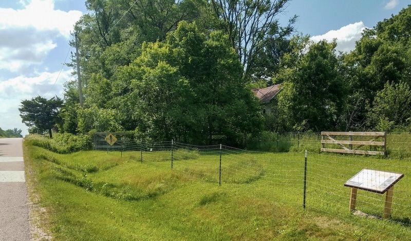
2. The Rest of the Man Mound Marker and the Man Mound's recreated legs
Photo - Ethan Brodsky - April 2014
Photo - Zach Crab -September 2019
Apple Trees at the Man Mound's Feet
Photographs of the Man Mound from about 1908 show the area of the feet as being a part of an apple orchard. To remember that period of the history of this land, two apple trees are being planted near the Man Mound's feet. Not just any apple trees, these are a heritage variety known as Dockham Russet which originated here in the Town of Greenfield prior to 1877. The trees being planted here were grafted from cuttings from a tree on land which is now owned by the Ho-Chunk Nation, part of what was once the Badger Ordnance Works, and previously the farmstead of the Steuber family. Before being taken by the U.S. Government by the Treaty of 1838, that land, as well as the land of the Man Mound, had for time immemorial been the property of the Ho-Chunk People and remains part of the Ho-Chunk People's ancestral homeland.
Topics. This historical marker is listed in these topic lists: Anthropology & Archaeology • Charity & Public Work • Indigenous Peoples and Communities • Parks & Recreational Areas. A significant historical year for this entry is 1908.
Location. 43° 29.328′ N, 89° 40.297′ W. Marker is near Baraboo, Wisconsin, in Sauk County. It is in Town of Greenfield. It is on Man Mound Road, on the right when traveling west. The marker is on the north side of the road across from Man Mound Park. Touch for map. Marker is at or near this postal address: E13085 Man Mound Road, Baraboo WI 53913, United States of America. Touch for directions.

Regionally, this marker is in Greater Madison. It is also in the American Midwest, in the Corn Belt, and in the Driftless Area — Bluff Country. Globally, it is in North America, the Western Hemisphere, the Western World, and the Anglosphere. Historically, it finds itself in what was once the territory of the Mississippian Culture and also the Northwest Territory.
Other nearby markers. At least 8 other markers are within 4 miles of this marker, measured as the crow flies: Man Mound (within shouting distance of this marker); Man Mound Park (within shouting distance of this marker); The Lower Narrows (approx. 2.2 miles away); Indian Mounds and Village (approx. 3.2 miles away); Ringling Brothers Circus (approx. 3.4 miles away); No. 19 Cole Bros. Circus Seal Lion Den (approx. 3½ miles away); The Ringling Brothers of Baraboo (approx. 3½ miles away); Ringling Bros. Circus (approx. 3½ miles away). Touch for a list and map of all markers in Baraboo.
Another marker is no longer nearby. Man Mound (was within shouting distance of this marker but has been permanently removed).
Credits. This page was last revised on November 16, 2026. It was originally submitted on November 16, 2026, by McGhiever of Minneapolis, Minnesota. This page has been viewed 4 times since then. Photos: 1, 2. submitted on November 16, 2026, by McGhiever of Minneapolis, Minnesota.
